Download
3D Flyover
Add to list
More
8.4 km
~1 hrs 40 min
0 m
Out and Back
“Wander willow-lined paths, tidal wetlands, and riverside views—where history, wildlife, and Dutch landscapes intertwine.”
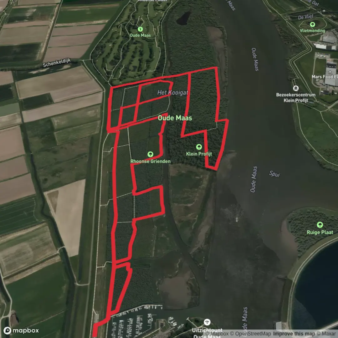
Starting from the outskirts of Rhoon, just a short walk from Rhoon Metro Station, this loop trail covers approximately 8 km (about 5 miles) with virtually no elevation gain, making it accessible for hikers of all abilities. The trailhead is conveniently located near the Rhoon Castle (Kasteel van Rhoon), a recognizable landmark and a great spot to orient yourself before setting off.
Getting There
For those using public transport, take the Rotterdam Metro D line to Rhoon Station. From there, it’s a 10-minute walk west along Dorpsdijk to the castle grounds, where the trail begins. If arriving by car, parking is available near the castle and along Dorpsdijk.
Trail Experience and Navigation
The route forms a gentle loop through the Rhoonse Grienden, a unique freshwater tidal wetland along the Oude Maas river. The terrain is flat and mostly consists of well-maintained dirt and gravel paths, with occasional boardwalks over wetter sections. Navigation is straightforward, but for added confidence and up-to-date trail conditions, use HiiKER for digital maps and waypoints.
Natural Highlights and Wildlife
The Rhoonse Grienden is renowned for its willow forests, which are periodically flooded by the tides of the Oude Maas. This rare ecosystem supports a variety of birdlife, including herons, kingfishers, and sometimes even cormorants. In spring and early summer, the area bursts with wildflowers and the buzzing of insects, while autumn brings a golden hue to the willows. Keep an eye out for roe deer and rabbits, especially in the quieter stretches.
Landmarks and Points of Interest
- Kasteel van Rhoon (0 km / 0 miles): The starting point, this 15th-century castle is surrounded by landscaped gardens and moats, offering a glimpse into the region’s feudal past.
- Tidal Wetlands (2–5 km / 1.2–3.1 miles): The heart of the hike, these wetlands are crisscrossed by small dikes and drainage channels, remnants of centuries-old land management. Interpretive signs along the way explain the history and ecology of the area.
- Oude Maas Riverbank (5–7 km / 3.1–4.3 miles): The trail skirts the river, providing wide views across the water and a chance to spot passing ships. Benches along the bank make for pleasant rest stops.
- Return through Farmland (7–8 km / 4.3–5 miles): The final stretch leads through open fields and pastures, dotted with grazing sheep and traditional Dutch farmhouses.
Historical Significance
The Rhoonse Grienden are a living testament to Dutch water management. For centuries, local farmers harvested willow branches here for use in dike reinforcement and basket weaving. The area’s network of dikes and sluices reflects the ongoing battle against the tides, a theme central to the history of South Holland.
Preparation Tips
Waterproof footwear is recommended, especially after rain, as some sections can be muddy. There are no steep climbs, but the exposed riverbank can be windy. Bring binoculars for birdwatching and a camera for the scenic views. Facilities are limited along the route, but cafes and restrooms are available near the castle at the start and end of the hike.

Surfaces
Unknown
Unpaved
Asphalt
Wood
Comments and Reviews
User comments, reviews and discussions about the Rhoonse Grienden and Oude Mass Loop, Netherlands.
average rating out of 5
0 rating(s)