Download
3D Flyover
Add to list
More
36.7 km
~2 days
273 m
Point-to-Point
“A full-day ramble of purple heaths, whispering pines, and sandy lanes, with wind-kissed IJssel views.”
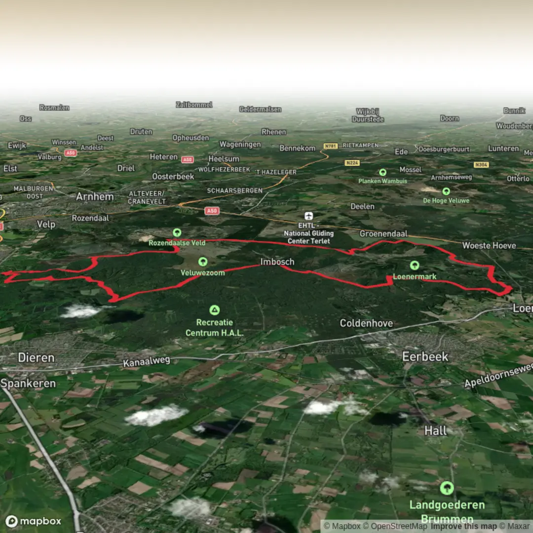
This is a long, mostly flat-to-gently-rolling day through two of the Netherlands’ most varied heath-and-forest landscapes: the southern edge of Nationaal Park Veluwezoom and the open, quieter Loenermark. Expect wide sandy tracks, springy pine-needle singletrack in places, and long stretches of purple heath (late summer) broken up by oak and beech woodland, small fens, and occasional viewpoints over the IJssel valley. At around 37 km / 23 mi with roughly 300 m / ~985 ft of total ascent, it’s “easy” in terms of steepness, but it’s still a full-day endurance walk—plan for time on your feet, wind exposure on the heaths, and a few navigation decision points where paths braid together.
Getting to the start (public transport + car)
By public transport (most common approach):
- The most practical rail hub is Arnhem Centraal. From there, buses run toward Rheden/De Steeg (common gateways to Veluwezoom).
- A typical plan is: train to Arnhem Centraal, then bus to Rheden (near the park edge). From Rheden you can walk a short distance to the trail network and pick up the route.
- Use HiiKER to confirm the exact stop closest to your chosen trailhead and to match it to the route line, because bus routes and stop names can vary by season and operator.
By car:
- Aim for one of the established Veluwezoom access points near Rheden / De Steeg—popular options in this area include parking around the Veluwezoom visitor access near Rheden and the well-known park gateway at Posbank (busy on weekends and during heather bloom).
- Arrive early if you’re starting near Posbank: it’s a major draw for day visitors, cyclists, and photographers.
If you share the missing “Hike head: near …” detail (or any coordinates), I can pin it to the nearest named car park, bus stop, or landmark and tailor the first/last kilometers precisely.
You’ll generally begin on firm paths through mixed woodland before the landscape opens onto heath and sandy lanes. The first 6–10 km / 4–6 mi are usually the “settling in” section: easy gradients, lots of junctions, and the first chances to spot wildlife at the forest-heath boundary. Even though the elevation gain is modest overall, you’ll feel a gentle rhythm of short rises and dips—classic Veluwe terrain shaped by ancient glacial deposits and windblown sands.
As you approach the Veluwezoom high points, the route’s most noticeable climbing tends to come in small packets rather than one big hill. Over the middle third you’ll likely accumulate the bulk of the ~300 m / ~985 ft ascent, often without realizing it because the climbs are gradual and the views distract you.
Heathland, viewpoints, and the “Lange Juffer” section
The Veluwezoom is famous for broad heathland and open ridgelines—this is where you’ll get the biggest sense of space. On clear days, viewpoints in this region can look out toward the IJssel valley and across rolling woodland. The “Lange Juffer” name is associated locally with the character of these older route lines and place-names on the Veluwe; on the ground, what matters for hikers is that this portion often threads between open heath and forest edges, where paths can split into parallel sandy tracks.
What to look out for here: - Wind exposure: even on mild days, open heath can feel cooler and more drying than the forest. Bring a light layer and keep water accessible. - Path braiding: multiple similar-looking tracks can run side-by-side. Keep HiiKER handy and confirm at junctions rather than “following the most used” track, especially after busy weekends. - Seasonal color: late summer heather bloom can be spectacular, but it also draws crowds near the most famous viewpoints.
From roughly km 10 to km 22 (6 to 14 mi) you’re in the most scenic, most “Veluwezoom” feeling terrain: alternating open heath, pine stands, and occasional beech/oak pockets. This is prime habitat for red deer, roe deer, and wild boar. You’re more likely to see deer at the quieter edges and early/late in the day; boar are often heard or seen as disturbed undergrowth rather than spotted clearly.
Wildlife etiquette and safety: - Wild boar: give them space, don’t approach for photos, and keep moving calmly if you encounter one. If you’re hiking with a dog, keep it leashed—boar can react defensively. - Ticks: heath and forest edges are tick territory from spring through autumn. Long socks, repellent, and a tick check at breaks are worth it.
Loenermark: quieter sands, open commons, and long cruising kilometers
As you transition toward Loenermark, the feel typically becomes more open and less “touristed” than the Posbank core. Loenermark is known for its heath commons, drifting sands, and wide horizons—excellent for steady pacing. Underfoot, you may encounter longer sandy stretches; they’re not steep, but sand can slow you down and increase fatigue late in the day.
This is where the route’s “easy” rating can be misleading: the terrain is technically straightforward, but the combination of distance and sand can make the final 10–15 km / 6–9 mi feel longer than the map suggests. Plan your food so you’re still fueling in the last third, not

Surfaces
Unknown
Concrete
Dirt
Sand
Asphalt
Gravel
Grass
Unpaved
Ground
Paved
Comments and Reviews
User comments, reviews and discussions about the Veluwezoom and Loenermark via Lange Juffer, Netherlands.
average rating out of 5
0 rating(s)