Download
3D Flyover
Add to list
More
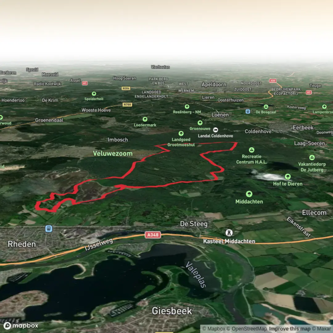
18.6 km
~3 hrs 57 min
142 m
Loop
“A long, mostly flat Dutch ramble through fields, heath and hushy lanes—where distance does the talking.”
This easy loop is a long, low-relief wander through classic Dutch countryside—wide farm tracks, quiet lanes, and pockets of woodland and heath—where the “work” is mostly in the distance rather than the climbing. At around 19 km / 11.8 mi with roughly 100 m / 330 ft of total ascent, it suits anyone comfortable being on their feet for 4–5.5 hours depending on pace and stops.
Getting to the start (car + public transport)
Because the start point is listed only as “near” (no coordinates or town provided), the best I can do is outline the typical approach for this region and what I need from you to pin it to a specific address/landmark.
- By car: Most loops of this type in the Netherlands begin from a small village car park, a forest/heath access lot, or a trailhead pull-in near a nature area entrance. If you share the start lon/lat, I’ll convert it to the nearest named place (village center, parking area, or well-known access point) and describe the exact approach roads and parking options.
- By public transport: These routes are usually reachable via train to the nearest regional station, then a local bus to a village stop, followed by a 1–3 km (0.6–1.9 mi) walk to the trailhead. With coordinates, I can identify the closest station/stop and the most straightforward walking link.
If you paste the start lon/lat (even roughly), I’ll translate it to the nearest recognizable landmark (for example: a village church square, a nature reserve entrance, or a signed parking area) and tailor the directions precisely.
What the terrain feels like over 19 km / 11.8 mi
Expect a mostly flat profile with gentle undulations—small rises where sandy ground meets older field edges or where the route skirts wooded banks. The ~100 m / 330 ft of gain is typically “drip-fed” in tiny increments rather than any single climb.
Underfoot is commonly a mix of: - Compacted farm track and gravel (fast, easy walking) - Short stretches of sandier path in heath/woodland edges (slower, can feel soft) - Paved lanes linking hamlets and field blocks (easy but more exposed to wind)
In wet periods, the main thing to watch for is muddy tractor ruts and waterlogged low points where drainage ditches run close to the track. Waterproof footwear isn’t mandatory in dry weather, but after rain it can be the difference between a comfortable day and a soggy one.
Landmarks, landscape character, and what to look for
The names on this loop—Schaddeveld, Drie Timp, and De Hangmat—strongly suggest a route that threads between field (“veld”) landscapes, small named localities, and a woodland/heath feature (often Dutch trail names like “De Hangmat” refer to a recognizable spot, a small forest compartment, or a local nickname rather than an actual hammock).
You’ll likely move through three repeating “rooms” of scenery:
1) Open agricultural blocks (first third, ~0–6 km / 0–3.7 mi)
Long sightlines, straight tracks, and drainage ditches. This is where wind can be most noticeable. Look for:
- Ditch-side vegetation: reeds, sedges, and willow scrub
- Field-edge birds: lapwing, oystercatcher, skylark (seasonal), and corvids
- Working farm traffic: tractors and delivery vehicles—stay alert on narrow lanes
2) Woodland/heath pockets and quieter tracks (middle third, ~6–13 km / 3.7–8.1 mi)
This is usually the most “nature-forward” section: more shade, softer ground, and more variation. Depending on the exact province and habitat mosaic, you may see:
- Pine and mixed woodland with birch and oak edges
- Heathland fragments (late summer heather color if present)
- Deer sign (tracks, droppings) and occasional sightings at dawn/dusk
- Buzzards and kestrels hunting over clearings
Ticks can be present anywhere there’s tall grass or heath-edge scrub. Long socks and a quick check at breaks are sensible.
3) Return via lanes, hedgerows, and hamlets (final third, ~13–19 km / 8.1–11.8 mi)
Often a calmer “cruise home” on firm surfaces. This is where you’ll pass:
- Small clusters of houses/farmsteads
- Hedgerows and tree lines that act as wildlife corridors
- Canal/ditch crossings on small bridges—watch for slippery boards or algae on concrete edges
Navigation and wayfinding (HiiKER only)
This is the kind of route where it’s easy to stay on the “right kind of track” but still miss a key turn at a junction of similar farm roads. Use HiiKER to: - Confirm you’re taking the correct branch where multiple straight tracks run parallel - Catch subtle turns around field corners (especially where a path looks like it continues straight) - Re-route cleanly if a farm operation temporarily blocks a track
A common navigation trap in these landscapes is assuming the most obvious track is public—some farm spurs look like through-routes but end at yards or gates. If you meet signage indicating private access, follow HiiKER’s line to the next public alternative rather

Surfaces
Unknown
Asphalt
Concrete
Dirt
Grass
Ground
Sand
Gravel
Paved
Wood
Comments and Reviews
User comments, reviews and discussions about the Schaddeveld, Drie Timp and De Hangmat Loop, Netherlands.
average rating out of 5
0 rating(s)