Download
3D Flyover
Add to list
More
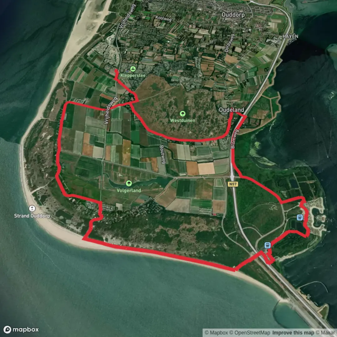
15.8 km
~3 hrs 9 min
0 m
Loop
“A windswept Ouddorp loop where lighthouse views, shifting dunes, and sea-dike calm test your stride.”
You’re looking at a classic Goeree-Overflakkee coastal loop: wide, level walking (about 16 km / 10.0 mi with roughly 0 m / 0 ft of climbing) that stitches together dune paths, sandy tracks, and sea-dike-style walking near Ouddorp. Even though the elevation gain is essentially nil, expect a “workout” from wind exposure and occasional soft sand.
Getting to the start (car + public transport)
Best “nearest known” start landmark: the Westhoofd Lighthouse (Vuurtoren Westhoofd) area on the west side of Ouddorp. The lighthouse’s listed address is Groenedijk 62, 3253 LB Ouddorp, Netherlands. (vuurtorens.org)
Visschershoek itself is an old farmhouse area near this lighthouse and the dunes, on the far western end of Goeree-Overflakkee. (en.wikipedia.org)
- By car: Navigate (in HiiKER) to Vuurtoren Westhoofd / Groenedijk 62, Ouddorp and use the nearby dune/strand parking areas. This is a popular access point for dune walks, so arrive earlier on sunny weekends.
- By public transport: The most practical approach is bus-to-Ouddorp and then a short taxi/bike/walk connection toward the lighthouse/dunes. A useful nearby reference is Marina Port Zélande (Kabbelaarsbank 5.01, 3253 ME Ouddorp), which notes Connexxion bus line 104 stopping a short walk from the marina entrance—handy if your loop swings that direction or if you’re building a point-to-point variant. (mpz.nl)
(Use HiiKER to pin the exact trailhead you want—lighthouse-side or marina-side—then match it to the closest bus stop.)
What the route feels like underfoot
This loop is “easy” mainly because it’s flat and non-technical—but it’s still a true coastal hike: - Dune paths: firm sand, occasional loose sections, and short, rolling micro-undulations that don’t add meaningful elevation gain. - Hard-packed tracks and dike-top walking: fast, straightforward miles where wind can be relentless. - Beach-adjacent segments (depending on the exact HiiKER line): sand can slow your pace dramatically; plan time accordingly.
A realistic moving pace for most hikers is often 4–5 km/h (2.5–3.1 mph) on firm surfaces, but 3–4 km/h (1.9–2.5 mph) if you hit long sandy stretches or strong headwinds.
Landmarks you’ll notice (and why they matter)
Westhoofd Lighthouse (Vuurtoren Westhoofd) is the big anchor landmark for orientation. The current tower was built 1947–1948 and is about 52 m (171 ft) tall; it replaced an earlier lighthouse from 1911 that was destroyed near the end of World War II. (en.wikipedia.org)
Even when you’re not right beside it, it’s a constant reference point across the dunes and polders—great for “big picture” navigation when paths braid and rejoin.
Visschershoek is tied to an old farmhouse site near the dunes and lighthouse area—part of the cultural landscape of this island edge where farming, dunes, and maritime navigation meet. (en.wikipedia.org)
If your loop includes the named stop D’n Dolle Beer, note that it’s historically associated with a beach café/restaurant at De Punt (West) 7, 3253 MC Ouddorp—useful as a waypoint for breaks and as a “civilization check” on a windy day. (eet.nu)
Nature, scenery, and wildlife to look for
This corner of South Holland is all about the contrast between dunes and polder-flat hinterland: - Dune ecology: expect tough, salt- and wind-tolerant vegetation (dune grasses, low scrub) and frequent signs of sand movement where paths drift. - Birdlife: coastal and dune edges are prime for gulls, terns, and waders; inland edges and wetter pockets can hold more songbirds and raptors riding the wind. - Mammals: you

Surfaces
Asphalt
Unknown
Sand
Grass
Concrete
Gravel
Comments and Reviews
User comments, reviews and discussions about the Visschershoek and D'n Dolle Beer Loop, Netherlands.
average rating out of 5
0 rating(s)