Download
3D Flyover
Add to list
More
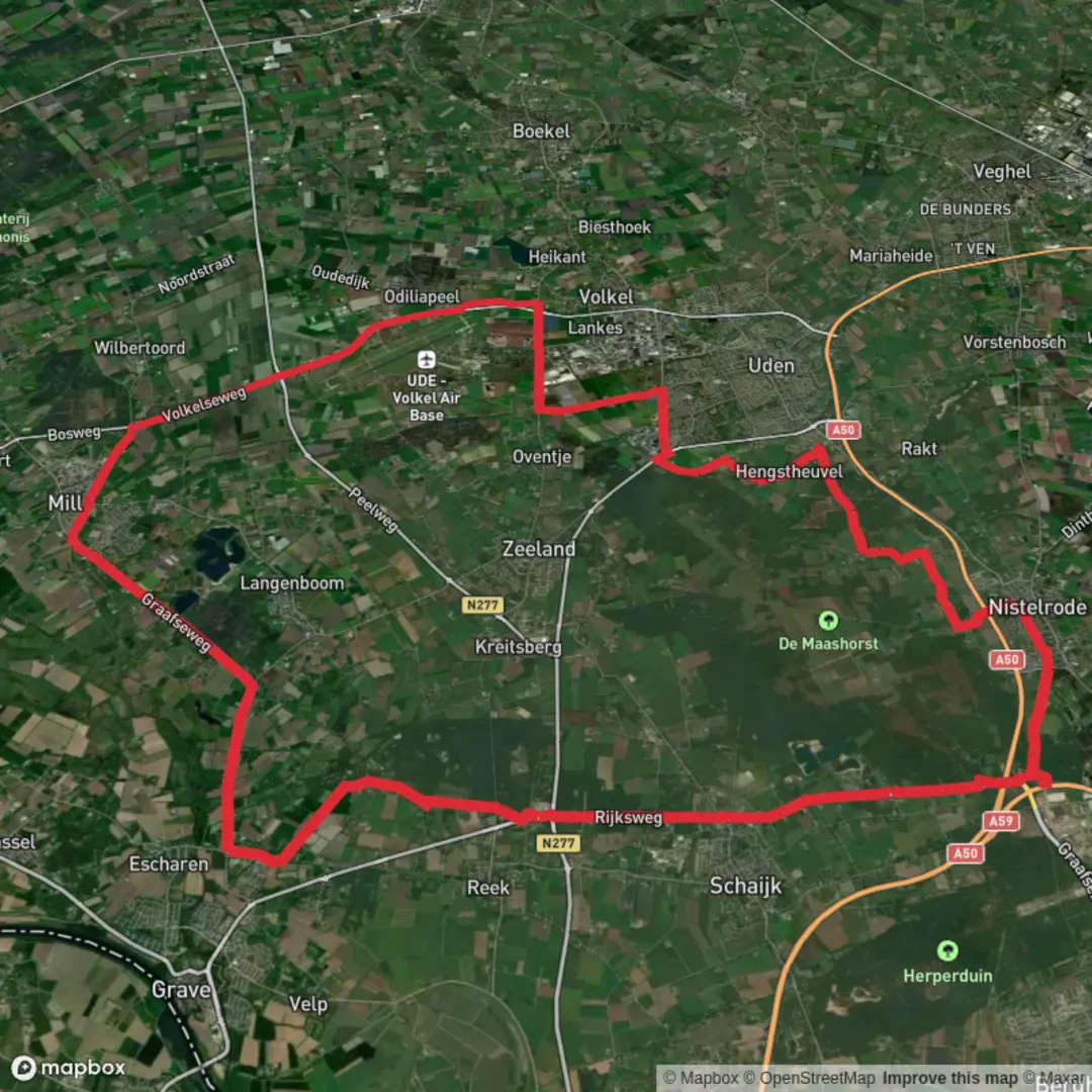
49.4 km
~2 days
0 m
Point-to-Point
“A long, flat wander through Brabant fields and waterways—easy to start, quietly testing by day’s end.”
This is a long, low-commitment day on the legs rather than a climbing day: roughly 49 km / 30.4 mi with essentially 0 m / 0 ft of elevation gain. Expect a predominantly flat route on a mix of paved cycle paths, quiet rural lanes, and well-surfaced tracks typical of the Dutch countryside—excellent for steady pacing, but it can feel deceptively demanding because there’s very little terrain variation to “force” breaks.
Getting to the start (car + public transport)
Because the start point is listed only as “near” (no coordinates or town provided), the most practical way to plan transport is to anchor the start around the Rijksweg / Hoogeweg area in the Uden / Zeeland (North Brabant) region, which is where those road names and the “Udenoord” place-name context most commonly fit.
- By car: Aim for parking near a prominent, easy-to-find landmark such as Uden town center (around Markt, 5401 EJ Uden, Netherlands) or a trail-adjacent car park near local nature areas (often signed as P for walkers). From there, you can link onto the cycle-path network that parallels main roads like the Rijksweg.
- By public transport: The usual approach is train to ’s‑Hertogenbosch (Den Bosch) or Oss, then a regional bus toward Uden. Uden is well-served by buses even though it doesn’t have its own rail station. Once in Uden, you can walk a short distance to connect with the route corridor.
If you share the lon/lat for the start (or a GPX), I can convert it to the nearest known address/landmark precisely and tailor the transport directions to the correct stop and walking link.
What the day feels like underfoot - Surface & footing: Mostly firm and fast—pavement, brick cycleways, compacted gravel. Trail shoes are fine; road shoes also work in dry conditions. After rain, the unpaved sections can hold water in low spots, but you’re unlikely to face mud that stops progress. - Effort profile: With no meaningful climbing, the challenge is time-on-feet. Plan for 8–12 hours depending on pace and breaks. The flatness makes it easy to start too fast; a conservative first 10 km / 6.2 mi pays off later. - Wind exposure: Open agricultural stretches can be surprisingly windy. A light shell can matter more than you’d expect on a “flat easy” route.
Route character: roads, farms, and water
You’ll be moving through a classic North Brabant mosaic: fields, drainage ditches, small woodlots, and village edges. The “Rijksweg” segments typically mean you’re near a principal road corridor, but in the Netherlands that often comes with parallel cycle paths that keep you separated from traffic. “Hoogeweg” sections are usually quieter rural connectors—good for settling into rhythm.
Look out for: - Canals/ditches and small bridges: frequent crossings and straight-line water management features that define the landscape. - Farm traffic: tractors and delivery vehicles on narrow lanes; they’re usually courteous, but give them space and expect occasional short waits. - Cycle traffic: fast e-bikes are common—stay predictable on shared paths.
Landmarks, nature, and wildlife to notice - Heath/wood edges and small nature reserves: The names “De Kuilen” and “Udenoord” suggest you’ll pass near managed natural areas and possibly former extraction pits or low-lying basins (kuilen can refer to pits/holes). These places often have ponds, sandy soils, and pine/birch stands, with a noticeably different feel from the surrounding farmland. - Birdlife: Expect abundant waterfowl (mallard, coot, moorhen), herons, and seasonal migrants along wet margins. In open fields you may see buzzards and other raptors riding the wind. - Mammals: Rabbits and hares are common; roe deer are possible near wooded edges, especially early/late in the day. - Insects: In warm months, bring repellent—still water and sheltered hedgerows can mean mosquitoes and midges.
Historical context (what you’re walking through) This part of North Brabant has long been shaped by: - Agriculture and land reclamation: the straight ditches, raised lanes, and carefully managed water levels reflect centuries of drainage and field organization. - Village-to-market connectivity: roads like a “Rijksweg” corridor historically tied settlements to regional trade routes, later modernized for motor traffic while retaining parallel slow-traffic infrastructure. - Heathland transformation: many Brabant heaths were historically common grazing lands and later converted through forestry and cultivation; remaining patches are often protected and feel like “islands” of older landscape.
Planning essentials for a 49 km / 30.4 mi flat hike - Water & resupply: Even in populated regions, long rural connectors can be sparse for services. Plan to pass through at least one town/village where you can top up. Carry at least 1.5–2.5 L depending on temperature, and know where your refill points are. - Food: Treat it like an endurance day—aim for steady intake (snacks every 45–60 minutes). Flat terrain can hide energy drain until late. - Clothing: Wind layer, light rain protection, and a cap/sunglasses. On exposed lanes, sun and wind

Surfaces
Asphalt
Unknown
Concrete
Paved
Gravel
Wood
Sand
Comments and Reviews
User comments, reviews and discussions about the De Kuilen and Udenoord via Rijksweg and Hoogeweg, Netherlands.
average rating out of 5
0 rating(s)