Download
3D Flyover
Add to list
More
44.6 km
~2 days
205 m
Point-to-Point
“A long, gentle heath-and-pine loop where sandy ridges and quiet farmland invite steady, mindful pacing.”
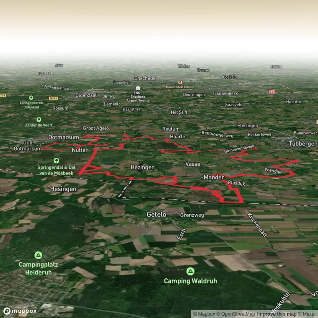
This is a long, low-relief loop of heathland, pine forest, drifting sand, and quiet farmland edges—ideal for steady pacing rather than steep climbing. At roughly 45 km / 28 mi with about 200 m / 650 ft of total ascent, the elevation changes are subtle: short rises onto sandy ridges, gentle undulations through forest, and small up-and-downs where paths cross old dunes and heather hummocks. Plan for a full day out (or a very early start), because the terrain is easy but the distance is not.
Getting to the start (car + public transport)
Because the start point is listed only as “near” (no coordinates provided), the most practical approach is to aim for the Haarle / Hellendoorn area on the Sallandse Heuvelrug (Overijssel, Netherlands)—the place names in the route title (Haarlerveld, Vasserheide, Manderheide, Mandercirkels) cluster around this landscape.
- By car: Navigate (in HiiKER) to a main access point for Haarlerveld such as the Haarle village area or a signed nature-area car park on the edge of the heath/forest. In this region, trailheads are typically at marked parking areas (“P” signs) near the reserve boundary; arrive early on weekends because these lots can fill quickly in good weather.
- By public transport: The most reliable pattern is train to a larger hub (e.g., Nijverdal or Holten) and then bus/taxi toward Haarle or a reserve entrance. From the village edge you can usually walk into the network of sandy tracks and heath paths that form the loop. If you share your intended start coordinates (lon/lat), I can convert them to the nearest named trailhead/landmark and suggest the cleanest transit approach.
Expect the first and last kilometers to be the most “logistical”—finding the correct track out of the village edge or car park and then returning to it late in the day when you’re tired. Keep HiiKER handy for those transitions.
You’ll likely begin on wide, firm tracks—often compacted sand or forest road—before the route quickly becomes a mix of: - Heath paths (narrower, sometimes soft underfoot) - Sandy lanes (can be energy-sapping in dry spells) - Pine/deciduous forest singletrack (rooty in places, shaded and cooler) - Straight forestry lines (fast but monotonous; easy to drift off at junctions)
The “easy” rating fits the gradients, but the distance makes this a serious outing. A good benchmark is to plan water/food as if for a marathon-length day: you want steady fueling from the first hour, not “when you feel hungry.”
What you’ll see: heath, forest, and the “circles”
The character of this loop is defined by Dutch heathland management landscapes—open purple-blooming heather in season, interspersed with pine plantations and patches of older mixed woodland. The named segments hint at distinct zones:
- Mandergeide / Manderheide: Expect open heath with big skies and long sightlines. These sections can feel exposed—windy in cooler months and hot in summer sun.
- De Mandercirkels: “Cirkels” strongly suggests circular landscape features—often associated with patterned land use, forestry design, or distinctive managed clearings. On the ground, these can appear as unusual geometry in paths, vegetation edges, or clearings. They’re easy to miss if you’re only watching your feet; look up occasionally and you’ll notice the shapes in the way tracks curve and radiate.
- Vasserheide: More heath and transitional scrub—often where you’ll see young birch and scattered pines encroaching at the margins, a classic sign of heath slowly turning back into woodland without active management.
- Haarlerveld: A well-known heath/forest mosaic where you may encounter broader sandy stretches and a more “wild” feel despite being in a managed reserve.
Wildlife is typically subtle but rewarding if you move quietly: - Deer (often at forest-heath edges early/late in the day) - Heathland birds (listen for calls over open ground; keep distance from ground-nesting areas) - Raptors over open heath on breezy days - Insects: in warm months, expect plenty of flying insects near wetter pockets and along sheltered forest edges
Underfoot conditions, pacing, and navigation
Most of the day is non-technical, but the surface changes can affect your pace more than the elevation does.
- Sandy sections: These are the biggest energy drain. Dry sand can slow you dramatically—your “easy” walk becomes a steady grind. If you hit a long sandy lane, shorten your stride and keep cadence consistent.
- Forest singletrack: Watch for roots and soft needles hiding uneven ground. After rain, roots can be slick.
- Heath paths: Can be narrow with low vegetation brushing your legs; in wet periods, some hollows hold water.
Navigation is generally straightforward on established tracks, but the risk comes from junction density: forestry grids create many similar-looking intersections. Use HiiKER to confirm you’re taking the correct branch, especially where multiple sandy roads meet at odd angles.
Landmarks and historical context to look out for
This part of the Netherlands has a long history of heathland shaped by grazing, sod-cutting, and later forestry. Heaths are not “unt

Surfaces
Unknown
Sand
Ground
Asphalt
Concrete
Dirt
Unpaved
Gravel
Grass
Comments and Reviews
User comments, reviews and discussions about the Mandergeide, De Mandercirkels, Vasserheide and Haarlerveld Loop, Netherlands.
average rating out of 5
0 rating(s)