Download
3D Flyover
Add to list
More
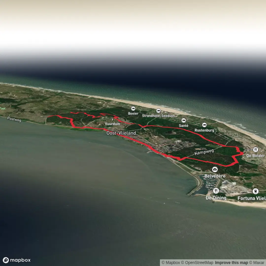
8.0 km
~1 hrs 39 min
32 m
Loop
“Wander windswept dunes, glimpse seals and spoonbills, and uncover Vlieland’s tranquil island heritage.”
Starting from the heart of Oost-Vlieland, the main village on the island of Vlieland in the Dutch Wadden Sea, this loop trail covers approximately 8 km (about 5 miles) with virtually no elevation gain, making it accessible for hikers of all abilities. The trailhead is conveniently located near the ferry terminal, making it easy to reach whether you arrive by public transport or car. Ferries to Vlieland depart from Harlingen Haven, which is accessible by train and bus from major Dutch cities. Once on the island, the village and trailhead are a short walk from the ferry dock.
Exploring the Dunes and Coastal Landscapes
The route quickly immerses you in the unique landscapes of Vlieland, one of the Frisian Islands. Expect to traverse wide sandy paths bordered by marram grass, low dunes, and stretches of heathland. The trail follows part of the Waddenwandelen network, renowned for its connection to the UNESCO-listed Wadden Sea, a vital habitat for migratory birds and marine life. Keep an eye out for spoonbills, oystercatchers, and seals basking on distant sandbanks.
Pad van de Staatsschuur and Historical Context
Midway through the loop, you’ll encounter the Pad van de Staatsschuur, a path named after the historic government barn (Staatsschuur) that once stored grain and supplies for the island’s residents. This area is steeped in history, with remnants of old dikes and references to Vlieland’s centuries-old struggle against the sea. Interpretive signs along the route provide insight into the island’s agricultural and maritime heritage.
Navigational Tips and Points of Interest
Navigation is straightforward, with well-marked paths and signposts. For detailed route guidance and offline maps, use HiiKER, which offers up-to-date trail information and GPS navigation. The loop passes through tranquil pine forests planted to stabilize the dunes, and open stretches where you can see the North Sea on one side and the Wadden Sea on the other. The absence of significant elevation (0 metres/0 feet) means the walk is gentle, but be prepared for sandy sections that can be tiring on the legs.
Wildlife and Seasonal Highlights
Spring and autumn are particularly rewarding for birdwatchers, as the Wadden Sea is a critical stopover for migratory species. In summer, the dunes are dotted with wildflowers, and the salty air carries the calls of gulls and terns. The island’s isolation and limited vehicle access ensure a peaceful hiking experience, with only the occasional cyclist or fellow walker for company.
Getting There and Practicalities
To reach Vlieland, take the ferry from Harlingen Haven. Parking is available at the ferry terminal, but cars are not permitted on the island for visitors, so plan to explore on foot or by bicycle. The trailhead is a short walk from the ferry, and amenities such as cafes, shops, and restrooms are available in Oost-Vlieland. Bring water and snacks, as there are limited facilities once you leave the village.
This easy, scenic loop offers a perfect introduction to the wild beauty and rich history of Vlieland, with sweeping views, abundant wildlife, and a sense of tranquility unique to the Wadden Islands.

Surfaces
Unknown
Ground
Dirt
Gravel
Sand
Asphalt
Comments and Reviews
User comments, reviews and discussions about the Waddenwandelen - Vlieland and Pad van de Staatsschuur Loop, Netherlands.
average rating out of 5
0 rating(s)