Oude Post Weg, Pad van Malgum and Waddenwandelen - Vlieland Loop
Download
3D Flyover
Add to list
More
35.0 km
~7 hrs 5 min
61 m
Point-to-Point
“Wander windswept dunes, lush forests, and salt-kissed shores, discovering Vlieland’s wild heart and historic soul.”
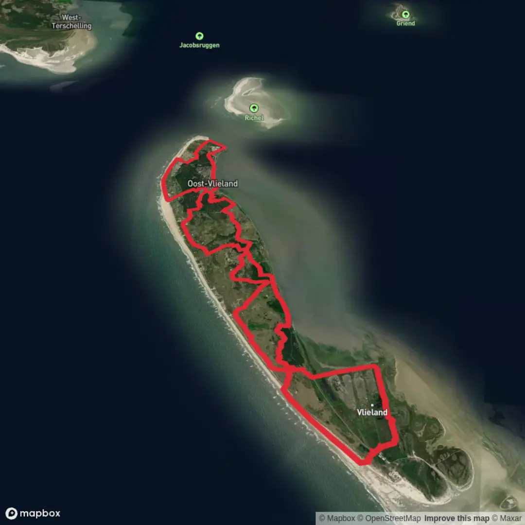
Starting your journey on Vlieland, a tranquil island in the Dutch Wadden Sea, the trailhead for this 35 km (about 22 miles) loop is conveniently located near the ferry terminal in Oost-Vlieland. Arriving by public transport is straightforward: take a train to Harlingen Haven, then board the ferry to Vlieland. Disembark and you’re just steps from the start. For those driving, parking is available in Harlingen, as cars are not permitted on Vlieland itself.
Coastal Dunes and Forests
The route quickly immerses you in the island’s unique landscape, beginning with sandy paths winding through the expansive dunes of the Kroon’s Polders nature reserve. Expect gentle undulations, with total elevation gain around 100 metres (328 feet), making this loop accessible for most fitness levels. The dunes are home to a variety of birdlife, especially during migration seasons, so keep binoculars handy for spotting avocets, spoonbills, and terns.
After about 7 km (4.3 miles), the trail enters the Vlieland forest, a patchwork of pine and deciduous trees planted to stabilize the dunes. The forest provides shelter from coastal winds and is a good spot to encounter deer and rabbits. The soft forest floor is easy on the feet, and the shade is welcome on sunny days.
Historic Routes and Village Charm
At roughly 15 km (9.3 miles), you’ll join the Oude Post Weg, a historic postal route once used for delivering mail across the island. This section is flat and open, offering sweeping views of the Wadden Sea and the tidal flats, which are UNESCO World Heritage-listed for their ecological significance. The tidal flats teem with life—look for seals basking on sandbanks at low tide.
Approaching the halfway mark, the trail passes near the village of Oost-Vlieland. This is the island’s only settlement, with charming brick houses, a 17th-century church, and several cafes and shops. It’s a good place to restock supplies or enjoy a meal before continuing.
Waddenwandelen and the Pad van Malgum
The next segment follows the Waddenwandelen route, a long-distance path tracing the Wadden Sea coast. Here, the landscape shifts to salt marshes and grassy polders, with panoramic views across the water to neighboring islands. The Pad van Malgum, a historic dike path, leads you through this area. Interpretive signs along the way explain the centuries-old battle against the sea and the importance of dike-building in Dutch history.
Wildlife is abundant—watch for grazing Highland cattle and flocks of geese in the marshes. The air is filled with the calls of waders and the scent of salt and wildflowers. The terrain remains easy, with well-marked, mostly flat paths.
Navigation and Practical Tips
Navigation is straightforward, with clear waymarking throughout. For digital navigation, HiiKER provides detailed maps and GPS tracks for the entire loop. Water sources are limited outside Oost-Vlieland, so carry enough for the day. Weather can change quickly on the island; pack layers and be prepared for wind and rain, even in summer.
Camping is only permitted at designated sites near the village, and wild camping is not allowed. Accommodation options include hotels, guesthouses, and a large campsite. The island’s compact size means you’re never far from help or shelter.
This loop offers a blend of natural beauty, wildlife, and Dutch coastal history, making it a rewarding and accessible adventure for hikers of all abilities.

Surfaces
Unknown
Ground
Sand
Dirt
Asphalt
Gravel
Concrete
Wood
Grass
Comments and Reviews
User comments, reviews and discussions about the Oude Post Weg, Pad van Malgum and Waddenwandelen - Vlieland Loop, Netherlands.
average rating out of 5
0 rating(s)