Download
3D Flyover
Add to list
More
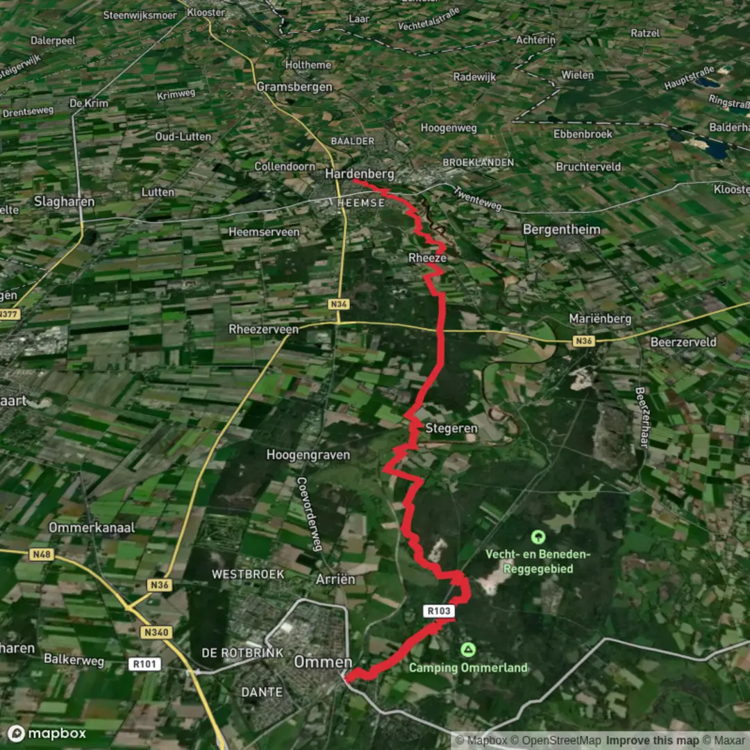
20.5 km
~4 hrs 7 min
14 m
Point-to-Point
“A long, flat wander from Hardenberg to Heemse, where wind, waterways, and wide fields set the mood.”
I’m missing a few key pieces of route data to describe this accurately (especially the start point and whether it’s a loop or point-to-point). If you paste the GPX/route link (or the start lon/lat), I’ll convert the coordinates to the nearest recognizable address/landmark and tailor the directions, landmarks, and turn-by-turn expectations.
That said, based on the place names, this is a flat, easy ~20 km / ~12.4 mi walk in and around Hardenberg and Heemse in Overijssel (Netherlands), typically mixing river landscapes, town edges, and quiet countryside paths—very manageable physically, but long enough that pacing, footwear, and wind/rain exposure matter.
Getting to the start (car + public transport)
By public transport (most common approach): - Aim for Hardenberg railway station (NS regional services; commonly reached via Zwolle/Emmen connections depending on where you’re coming from). - From the station area you can usually step straight onto sidewalks/paths that lead toward the Vecht corridor and the Heemse side of town. If your actual trailhead is elsewhere, share the coordinates and I’ll give the exact bus stop + walking link-up.
By car: - Hardenberg is straightforward via the N34 and regional roads. - Practical parking is usually easiest near Hardenberg station or central public car parks on the Hardenberg side, then you walk out onto the route. Exact “best” lot depends on the true trailhead—send the start point and I’ll pick the closest legal option.
What the hike feels like (distance, terrain, effort)
- Distance: ~20 km / ~12.4 mi
- Elevation gain: ~0 m / ~0 ft (expect only tiny rises at bridges, dikes, and underpasses)
- Difficulty: Easy (fitness-wise), but the length makes it a “steady all-day stroll” for many hikers.
Underfoot is typically a mix of: - paved town paths and cycleways, - compacted gravel or farm tracks, - occasional grassy/dirt sections that can turn slick after rain.
Because it’s flat, the main “effort” variables are wind, surface hardness (pavement fatigue), and weather exposure.
Route character and key places you’ll pass
You’ll likely be moving between three distinct zones suggested by the name:
1) Hardenberg (town edge + river influence) Hardenberg sits along the Vecht river system, and walks here often weave between built-up streets, green corridors, and open views where the town quickly gives way to fields. Expect: - easy navigation on signed paths/cycleways, - frequent crossings and junctions—good moments to double-check your line in HiiKER so you don’t drift onto a parallel cycle route.
2) Heemse (quieter residential + rural fringe) Heemse is closely tied to Hardenberg but tends to feel calmer once you’re off the main roads. This section often features: - neighborhood green strips and small parks, - transitions to farm lanes and field margins, - long, straight segments where distance ticks by quickly.
3) De Heetdelle (countryside/wetland-leaning name cues) “Delle” place names in the Netherlands often hint at low-lying ground—think wetter meadows, drainage ditches, and reedier edges. Even if the route stays on firm paths, you can expect: - more open farmland views, - ditches and small canals alongside tracks, - wetter verges in shoulder seasons.
If the route includes any dike-top walking, it’s usually very easy footing but can be windy and exposed.
Nature, wildlife, and what to look for
This part of Overijssel is classic lowland habitat: fields, hedgerows, drainage channels, and river-adjacent greenspace.
Common sightings/expectations: - Waterbirds along canals/ditches (ducks, coots, moorhens; herons are common in suitable habitat). - Raptors over open fields (often seen hovering or gliding along field edges). - Small mammals are more likely at dawn/dusk; during the day you’ll mostly notice tracks and movement in hedges.
Seasonal notes: - Spring: birdsong and active nesting—stay on the path edges and avoid disturbing field margins. - Summer: taller vegetation can narrow paths; bring sun protection because shade can be limited. - Autumn/Winter: mud and standing water near low spots; waterproof footwear pays off.
Historical context you can feel on the walk
Even without a single “big monument,” this landscape is shaped by centuries of Dutch water and land management: - The pattern of straight farm tracks, drainage ditches, and managed waterways reflects long-term efforts to make low ground productive and passable. - Towns like Hardenberg developed as regional hubs where river corridors and overland routes meet; you’ll often sense that in how paths funnel toward bridges, crossings, and older town approaches.
If you share the exact line of the route (GPX or HiiKER link), I can point out any specific historic structures you pass—older churches, mills, former estates, or notable bridges—based on the precise alignment.
Practical planning: time, food/water, and comfort
Time estimate (walking pace): - 20 km / 12.4 mi is commonly 4–5.5 hours of moving time depending on pace and stops.
Food & water: - In and around Hardenberg/Heemse you’ll usually have options to buy snacks/drinks early or

Surfaces
Unknown
Concrete
Asphalt
Unpaved
Gravel
Grass
Dirt
Sand
Comments and Reviews
User comments, reviews and discussions about the De Heetdelle, Hardenberg and Heemser, Netherlands.
average rating out of 5
0 rating(s)