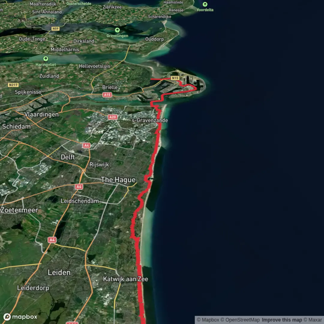
Noordwijk to Oostvoorne via Ganzenhoekweg, Prinsenweg and Cort van der Lindenpad
Download
3D Flyover
Add to list
More
65.9 km
~3 days
7 m
Multi-Day
“A windswept, big-sky trek from Noordwijk’s dunes through polder ribbons to Oostvoorne’s estuary hush—best for well-prepared walkers.”
This is a long, low-lying coastal-to-delta walk across South Holland, linking dune landscapes near Noordwijk with the island-and-estuary feel around Oostvoorne. At roughly 66 km / 41 miles with about 0 m / 0 ft of climbing, the challenge isn’t elevation—it’s time on feet, wind exposure, and managing long stretches of paved or hard-packed surfaces. Plan it as a very long day (12–16+ hours for most hikers) or, more realistically, a 2-day outing with a stop in or near The Hague/Hoek van Holland area depending on your pace and lodging preferences.
Getting to the start (and where “near” is)
Because the start point is listed only as “near,” the most practical “nearest known” start reference for this route is Noordwijk aan Zee’s seafront area, around Koningin Wilhelmina Boulevard (Noordwijk aan Zee, Netherlands)—a common access point to the dune paths and coastal corridors that naturally feed into the inland tracks named in your route (Ganzenhoekweg, Prinsenweg, Cort van der Lindenpad).
By public transport (from major hubs):
- From Amsterdam Schiphol: frequent trains to Leiden Centraal, then bus connections toward Noordwijk/Noordwijk aan Zee.
- From Leiden Centraal: buses run to Noordwijk aan Zee; aim for stops near the boulevard/seafront so you begin right at the coastal edge.
By car: - Drive to Noordwijk aan Zee and use one of the public parking areas near the boulevard (paid parking is common in coastal towns). Starting near the seafront makes logistics simple and gives you immediate access to the dune/coastal network.
Finish logistics (Oostvoorne): A sensible “nearest known” finish reference is Oostvoorne village center, near Dorpsplein / the church area (Oostvoorne, Netherlands), with bus links toward Spijkenisse, Brielle, and Rotterdam-area connections. If you’re splitting the hike, check evening bus frequency in advance.
What the terrain feels like (and why it’s still “easy”)
Expect flat walking almost the entire way, but not uniform underfoot: - Dune and coastal paths early on: sandier, sometimes soft, with short boardwalk or compacted tracks. - Polder and agricultural lanes through the middle: long, straight, efficient walking on farm roads, dikes, and cycle paths. - Delta-edge and coastal reserve approaches toward Oostvoorne: a mix of dike tops, sheltered lanes, and reserve trails.
Even with minimal elevation gain, the route can feel demanding because: - Wind off the North Sea and across open polders can be relentless. - Hard surfaces (pavement/cycle path) can punish feet over 66 km. - Navigation complexity increases around towns, canal crossings, and dike junctions—use HiiKER to stay on the intended line and to confirm crossings/underpasses.
Key route character: dunes → polders → delta coast
The named segments—Ganzenhoekweg, Prinsenweg, and Cort van der Lindenpad—signal the classic South Holland pattern: local roads and paths stitching together between waterways, fields, and settlements. You’ll repeatedly encounter: - Canals and drainage ditches (the backbone of Dutch water management) - Dikes and raised embankments offering slightly drier footing and big skies - Bridges, locks, and pumping infrastructure—small but constant reminders that this landscape is engineered as much as it is natural
Landmarks, nature, and wildlife to watch for
Coastal dunes near Noordwijk - Look for dune grasses, scrub, and sheltered hollows where the wind drops and the temperature can feel noticeably warmer. - Wildlife is often subtle: songbirds in scrub, raptors hovering over open areas, and rabbits in dune edges. In quieter stretches you may spot fox tracks or movement at dawn/dusk.
Polder country and waterlines - The middle of the route is defined by wide horizons, straight waterways, and big agricultural parcels. - Birdlife is the headline: depending on season, expect geese, swans, herons, egrets, and gulls, plus waders in wetter margins. In spring and autumn migration periods, the variety can be striking. - You’ll pass frequent reedbeds—good places to pause quietly and scan for movement.
Approaching Oostvoorne - The landscape begins to feel more “delta-coastal,” with brackish influences and a stronger sense of proximity to the sea and estuary systems. - Oostvoorne sits close to notable dune and coastal nature areas; even if your exact line stays on lanes and pads, you’ll feel the shift in vegetation and the presence of coastal woodland pockets and dune-edge habitats.
Historical context you’ll feel underfoot
This walk crosses a region shaped by centuries of land reclamation, coastal defense, and water control. The flatness isn’t accidental: much of the surrounding countryside exists because of dikes, drainage, and managed water levels. The repeated pattern of canals, pumping stations, and raised embankments reflects the Netherlands’ long-running effort to keep the sea and rivers in balance with farmland and towns.
Near the coast and delta approaches, you’re also moving through an area historically tied to shipping, fishing, and trade, with settlements that

Surfaces
Unknown
Asphalt
Concrete
Paved
Comments and Reviews
User comments, reviews and discussions about the Noordwijk to Oostvoorne via Ganzenhoekweg, Prinsenweg and Cort van der Lindenpad, Netherlands.
average rating out of 5
0 rating(s)