Download
3D Flyover
Add to list
More
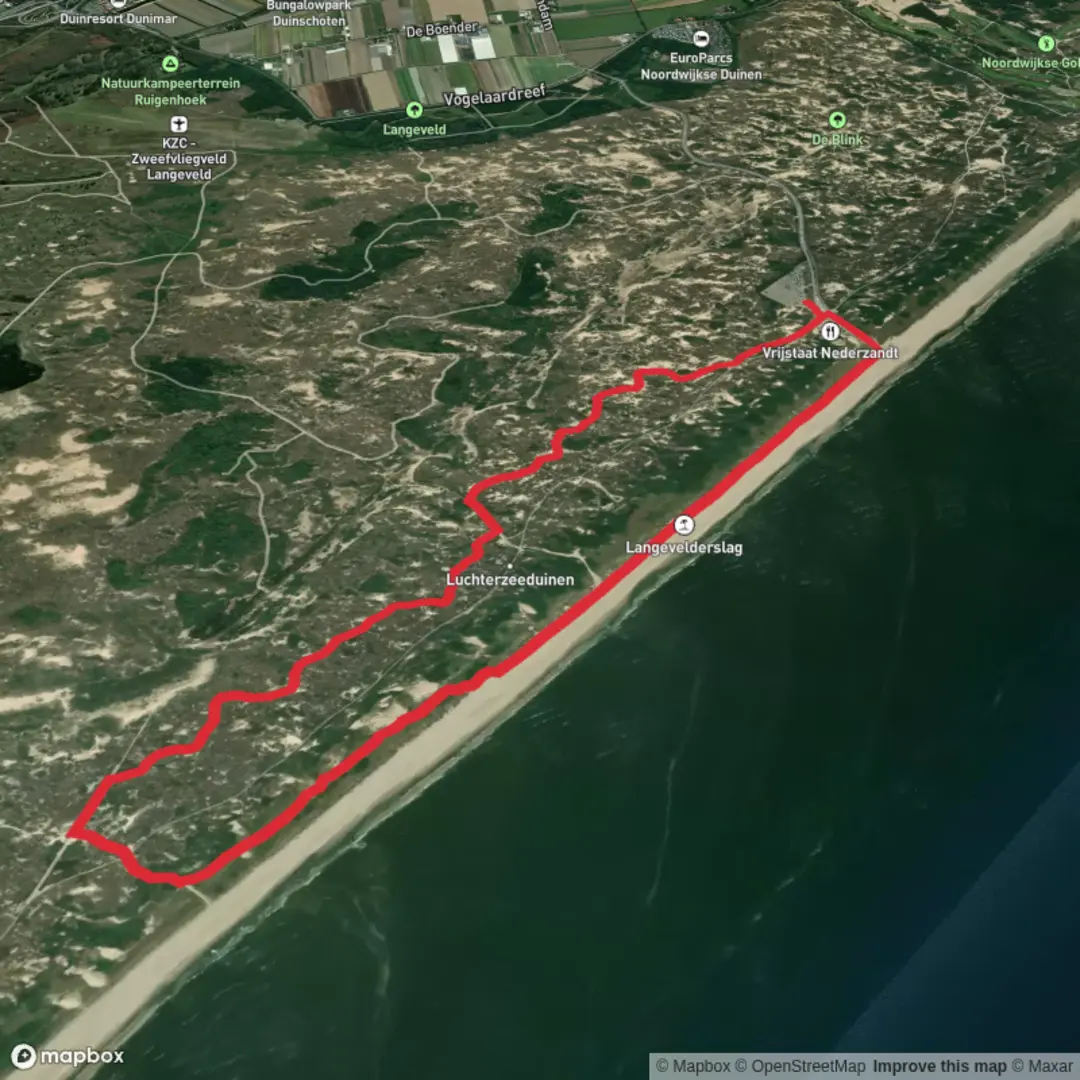
6.4 km
~1 hrs 17 min
0 m
Loop
“Wander through rolling dunes, sunlit beaches, and whispering forests where history and wildlife quietly intertwine.”
Langevelderslag Beach
Embarking on the Langeveldwandeling and Strandafrit Loop offers a delightful 6 km (approximately 3.7 miles) journey through the diverse landscapes of South Holland's coastal region. With virtually no elevation gain, this easy loop trail is perfect for hikers of all levels, providing a serene experience amidst dunes, forests, and beaches.
Getting There
To reach the trailhead near Langevelderslag Beach, you have several options:
By Car: From Amsterdam, drive approximately 45 km (28 miles) southwest via the A4 and N206 highways, following signs to Langevelderslag Beach. Parking is available near the beach entrance.
By Public Transport: Take a train from Amsterdam Centraal to Hillegom Station. From there, bus services or taxis can transport you to Langevelderslag Beach. It's advisable to check the latest schedules and routes before your trip.
Trail Overview
Starting at the parking area near Langevelderslag Beach, the trail meanders through a variety of terrains, offering hikers a rich tapestry of natural beauty and historical significance.
Dune Landscapes and Coastal Views
The initial segment of the trail guides you through the expansive dunes characteristic of the Holland Dunes region. These dunes, formed over centuries, serve as natural barriers protecting the inland areas from the North Sea's encroachment. As you traverse this sandy terrain, you'll be treated to panoramic views of the coastline, with the rhythmic sounds of waves accompanying your journey.
Strandafrit and Beach Walk
Approximately 2 km (1.2 miles) into the hike, you'll reach the Strandafrit section, leading you directly onto the pristine beaches of Noordvoort. This area is a designated beach reserve, serving as a resting area for seals. Walking along the shoreline, keep an eye out for these marine mammals basking in the sun. It's important to note that certain sections may have restrictions to protect wildlife; always adhere to local guidelines and signage. (alltrails.com)
Forested Paths and Wildlife
Leaving the beach, the trail transitions into dense pine forests, particularly around the Dennenbos area. This segment offers a shaded respite, with well-maintained paths winding through the woods. The forest is home to diverse wildlife, including deer and various bird species, making it a haven for nature enthusiasts. (alltrails.com)
Historical Significance
The region surrounding Langevelderslag is steeped in history. Nearby, the Amsterdamse Waterleidingduinen has been a vital water catchment area since the 19th century, supplying drinking water to Amsterdam. The dunes have also been inhabited since prehistoric times, with archaeological findings indicating early human settlements. As you hike, consider the generations that have traversed these lands before you.
Practical Tips
Navigation: While the trail is well-marked, it's recommended to use a reliable navigation tool like HiiKER to ensure you stay on track.
Footwear: Given the sandy and occasionally uneven terrain, sturdy hiking shoes are advisable.
Weather: Coastal weather can be unpredictable. Carry a light rain jacket and check the forecast before setting out.
Wildlife Etiquette: If you encounter wildlife, maintain a respectful distance and avoid feeding or disturbing the animals.
Embarking on the Langeveldwandeling and Strandafrit Loop provides a harmonious blend of natural beauty, wildlife encounters, and historical insights, making it a must-experience trail for those exploring the South Holland region.

Surfaces
Sand
Unknown
Unpaved
Asphalt
Concrete
Comments and Reviews
User comments, reviews and discussions about the Langeveldwandeling and Strandafrit Loop, Netherlands.
average rating out of 5
0 rating(s)