Download
3D Flyover
Add to list
More
13.3 km
~2 hrs 46 min
78 m
Point-to-Point
“Drift from Nijverdal to Holten along breezy heath and hushed pines, pausing at Noetselerberg and Holterberg’s wide, reflective views.”
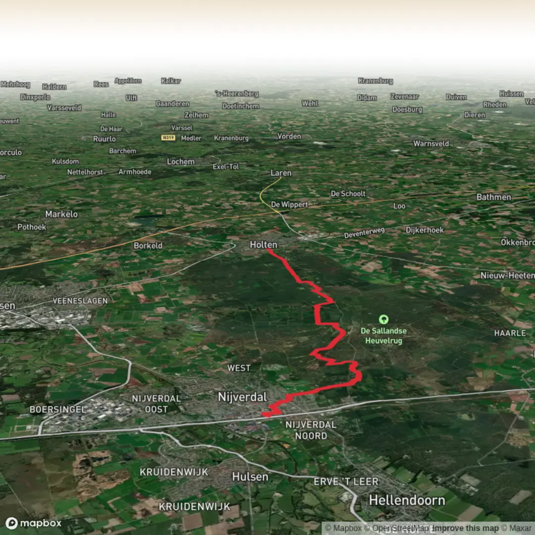
This is a gentle point‑to‑point walk across the Sallandse Heuvelrug ridge line, linking the edge of Nijverdal with Holten while visiting two of the area’s best viewpoints: Noetselerberg and Holterberg. Expect mostly well-made forest and heath paths, a few short sandy stretches, and frequent trail junctions where it helps to have the route loaded in HiiKER. At around 13 km (8.1 mi) with roughly 100 m (330 ft) of total ascent, it stays firmly in the Easy range, but the open heath can feel surprisingly exposed in wind or strong sun.
Getting to the start (and back)
Start area (nearest well-known place): the western edge of Nijverdal, close to the Sallandse Heuvelrug National Park access points on the town side (look for signed trailheads for “Noetselerberg” / “Sallandse Heuvelrug”). If you share the lon/lat you have for “near …”, I can pin it to the nearest street address or named trailhead/parking area.
By public transport - To Nijverdal: Trains run to Nijverdal station (regional services in Overijssel). From the station, you can walk or take a short local connection toward the park edge; many hikers simply walk from town to the signed trail network. - Return from Holten: Holten station is a convenient finish for a point‑to‑point hike. Trains connect back toward Nijverdal/Rijssen/Deventer depending on the service pattern. - Practical tip: because this is point‑to‑point, check train times before you set off so you’re not rushing the final kilometres.
By car - Park near a signed Sallandse Heuvelrug trailhead on the Nijverdal side (there are multiple small car parks at the forest edge). If you’re doing this with two cars, leave one near Holten (again, several small trailhead car parks exist on the Holterberg side) and shuttle back to Nijverdal.
What the trail feels like underfoot
You’ll be on a mix of: - Packed forest track (easy walking, can be muddy after rain) - Heathland paths (often sandy, sometimes rutted) - Short climbs that are steady rather than steep—more like “rolling ridge” than “hill hike”
After wet weather, the sandy sections can turn into soft, energy-sapping patches; after dry spells, they can be loose and dusty. Light trail shoes are usually fine, but choose something with decent grip if it’s been raining.
Route breakdown with landmarks and terrain
0.0–3.5 km (0.0–2.2 mi) | +40 m (+130 ft) approx.
Leaving the Nijverdal edge, the route quickly transitions from town-fringe woodland into the park’s characteristic mixed forest. The first climb is gradual, gaining height almost without noticing. You’ll pass frequent waymarkers and junctions—this is where having the line visible in HiiKER helps you avoid accidentally following a parallel loop.
3.5–6.5 km (2.2–4.0 mi) | +30 m (+100 ft) approx.
You’ll reach the Noetselerberg area, one of the classic high points on this side of the ridge. The landscape opens into heath and scattered pines, with longer sightlines across the undulating “heuvelrug” (ridge). On clear days, the contrast between dark conifer blocks and pale heath is striking. This is also where wind is most noticeable—pack a light layer even on mild days.
6.5–10.0 km (4.0–6.2 mi) | rolling, small ups/downs
The middle section traverses the ridge toward Holterberg, alternating between forest shade and open heath. The walking stays easy, but the constant small rises can add up if you’re not used to sandy footing. Keep an eye out for:
- Heather (heide) expanses (late summer can be especially colorful)
- Pine and birch edges where wildlife often feeds
- Occasional wide forestry tracks that make for fast progress
10.0–13.0 km (6.2–8.1 mi) | gentle descent toward Holten
Approaching Holten, the route gradually drops off the ridge. You’ll likely notice more intersecting paths and a slightly “busier” feel as you near popular access points. The finish into Holten is straightforward, but it’s easy to take a wrong turn at the last cluster of junctions—confirm your final approach in HiiKER, especially if you’re aiming for the station.
Nature, wildlife, and what to look out for
This ridge is famous for its heathland and forest mosaic, and it’s one of the Netherlands’ better places to spot wildlife without needing a long, remote trek.
- Red deer and roe deer: Most active at dawn/dusk; you may see tracks and droppings even if you don’t see the animals.
- Wild boar: Present in parts of the region; they’re usually shy, but give them space and keep dogs leashed.
- Birdlife: Heath and forest edges can produce woodpeckers, buzzards, and smaller songbirds; listen for drumming in the pines.
- Reptiles/insects on heath: On warm days, sandy edges can be lively—watch where you place hands/feet if you step off-trail for a

Surfaces
Sand
Unknown
Unpaved
Dirt
Asphalt
Ground
Paved
Comments and Reviews
User comments, reviews and discussions about the Nijverdal to Holten via Noetselerberg and Holterberg, Netherlands.
average rating out of 5
0 rating(s)