Download
3D Flyover
Add to list
More
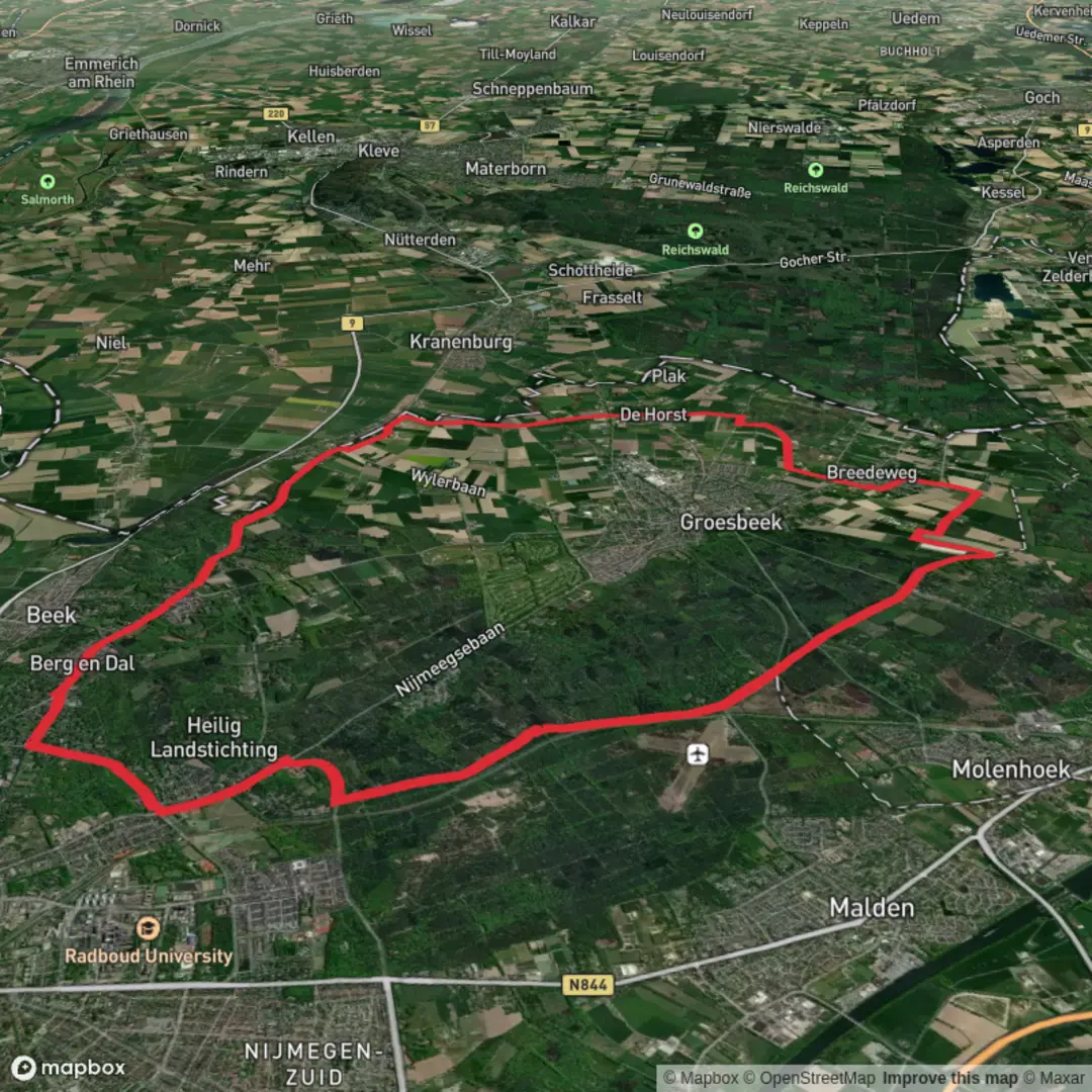
26.7 km
~5 hrs 31 min
103 m
Loop
“A low-effort, all-day wander through pine-and-beech woods and breezy heath—bring patience for sand and junctions.”
You’ll be walking a big, low-effort loop of roughly 27 km / 16.8 mi with only about 100 m / 330 ft of total climbing—classic “all-day easy” terrain where the challenge is more about time on feet, sandy stretches, and staying oriented at the many junctions than about steep ascents. Expect a steady rhythm of pine-and-beech woodland, heath and open clearings, and quiet forest tracks typical of the Utrechtse Heuvelrug area, with long sections that feel pleasantly remote despite being close to towns.
Getting to the start (car + public transport)
Because the start point in your details is incomplete (“near …”), the most practical, well-known access point for this landscape is Rhenen, which sits right on the edge of the ridge and has straightforward transport links.
- By public transport: Take the train to Station Rhenen (Rhenen, Netherlands). From there you can walk to the forest edge and connect into the network of tracks and paths that make up this loop area. (waze.com)
- By car: A convenient place to leave a vehicle is P+R Rhenen (Stationsplein, Rhenen), then walk out from the station area. (waze.com)
- If your intended start is closer to the Grebbeberg side, a commonly used trailhead/parking landmark is Parkeerplaats van het Militair Ereveld Grebbeberg, Grebbeweg 123, 3911 AV Rhenen. (visitheuvelrug.com)
If you share the route’s lon/lat (or the GPX), I can pin the start to the nearest specific address/landmark and describe the loop in the correct direction.
What the walking feels like underfoot
Most of this loop is typically on a mix of: - Wide forest roads (fast, forgiving, good in wet weather) - Narrower singletrack weaving through mixed woodland - Sandy patches on higher, drier ground—easy gradients, but they can quietly sap energy over 27 km / 16.8 mi
With only ~100 m / 330 ft of gain overall, climbs tend to be short rollers rather than sustained hills. You’ll notice the elevation more as gentle rises and dips than as “uphill sections.”
Navigation (keep it simple, but stay alert)
This area has a dense web of intersecting tracks. Even on an easy route, it’s very easy to drift onto a parallel path that “looks right” for a long time.
- Load the route in HiiKER and treat every major junction as a decision point.
- Watch for forks where one branch stays wide and straight while the correct route may take a smaller, less-worn line.
- In open heath/clearings, paths can braid and rejoin—double-check direction before committing.
Key sections and landmarks you’re likely to pass
Over a 27 km / 16.8 mi loop here, the day usually breaks into a few distinct “chapters”:
Forest ridges and quiet interior tracks (approx. 0–10 km / 0–6.2 mi)
You’ll settle into long, easy cruising on woodland paths. Expect tall conifers mixed with deciduous stands, with occasional straight plantation-style corridors and then more natural, curving sections. Wildlife is often subtle: listen for woodpeckers, watch for roe deer crossing early or late in the day, and scan sandy edges for tracks.
Openings, heath edges, and long sightlines (approx. 10–20 km / 6.2–12.4 mi)
This is where the landscape typically feels more “Heuvelrug”: brighter, breezier, with more sky and a sense of space. In late summer, heathland can be especially striking. These open stretches are also where you’ll feel weather most—sun, wind, or drizzle—so pack a layer even on mild forecasts.
Return through mixed woodland and junction-heavy terrain (approx. 20–27 km / 12.4–16.

Surfaces
Asphalt
Unknown
Concrete
Sand
Unpaved
Gravel
Paved
Comments and Reviews
User comments, reviews and discussions about the Holdeurn, Klein Amerika and Hooge Langeberg Loop, Netherlands.
average rating out of 5
0 rating(s)