Download
3D Flyover
Add to list
More
15.4 km
~3 hrs 5 min
0 m
Point-to-Point
“A mostly level stroll from Nijkerk to Ermelo, drifting past wind‑brushed fields and two storied kastelen.”
This is a flat, lowland point‑to‑point walk of about 15 km (9.3 mi) with roughly 0 m (0 ft) of climbing, linking the small city edge of Nijkerk to the greener outskirts and station area of Ermelo, while threading through classic Veluwe fringe scenery: straight estate lanes, drainage ditches, pasture and arable fields, and increasingly wooded patches as you near Ermelo. The two headline landmarks are Kasteel Oldenaller (Oldenallerallee 3, Putten) and Kasteel De Vanenburg (Vanenburgerallee 13, 3882 RH Putten). (commons.wikimedia.org)
Getting to the start (and back from the finish)
Start area (best practical trailhead): the most convenient “near” start is Nijkerk railway station (Station Nijkerk), because it’s easy to reach and sits naturally on a west‑to‑east line toward Putten/Ermelo.
- By train (public transport): Nijkerk is on the Dutch rail network; you can arrive by intercity/sprinter connections via Amersfoort and Zwolle corridors depending on your origin.
- By car: park near Station Nijkerk (paid/free options vary by lot and time). If you want to avoid a return journey, consider leaving a second car near Station Ermelo.
Finish: Ermelo railway station (Station Ermelo) is the simplest endpoint for a point‑to‑point hike. If you need to shorten the day, Putten station is also relatively close to Kasteel De Vanenburg (use HiiKER to choose the best cut‑off).
Return logistics: Nijkerk and Ermelo are connected by frequent regional options; the train between Nijkerk and Ermelo is very quick (about 10 minutes), making this route especially easy to do as a one‑way hike. (rome2rio.com)
Route flow and what to expect underfoot
0–3 km (0–1.9 mi): Nijkerk edge → open polder/field lanes
Leaving the station area, you’ll quickly trade sidewalks for quieter streets and then for farm tracks. Expect paved cycle paths, short residential connectors, and then hard-packed gravel or brick farm lanes. Because the elevation is essentially flat, the “difficulty” comes more from exposure to wind/rain and surface conditions than from climbing.
3–7 km (1.9–4.3 mi): toward Putten’s estate country
As you angle toward Putten, the landscape becomes more “Veluwe fringe”: long straight lanes, hedgerows, and drainage ditches. In wetter months, some unpaved stretches can be slick; waterproof shoes help even on an “easy” profile. Keep an eye out for:
- Waterfowl along ditches and small canals (ducks, geese, coots)
- Raptors over open fields (buzzards/kestrels are common in this region)
- Deer sign (tracks and droppings) as you approach more wooded estate edges
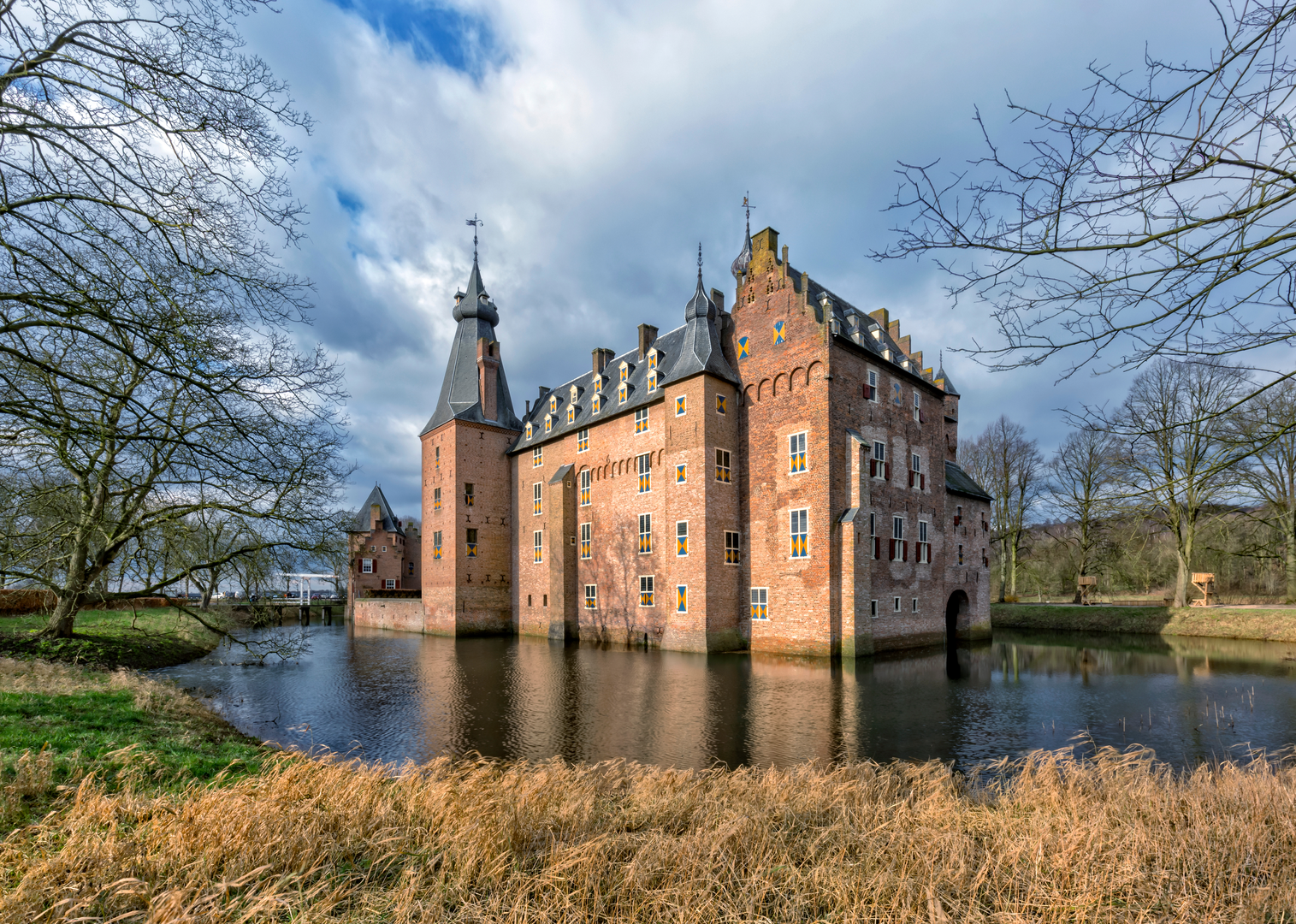
7–9 km (4.3–5.6 mi): Kasteel Oldenaller (key landmark + quiet estate lanes)
You’ll pass near Kasteel Oldenaller, a historic manor/castle site in Putten at Oldenallerallee 3. (commons.wikimedia.org)
This area typically feels calmer and more enclosed: mature trees, a more “designed” landscape, and the sense of moving through a long‑managed estate. Stay respectful around private drives and any signed restrictions—Dutch estates often allow passage on designated paths while keeping the immediate house grounds private.
9–11 km (5.6–6.8 mi): Kasteel De Vanenburg (estate core + formal lanes)
Next comes Kasteel De Vanenburg, at Vanenburgerallee 13, 3882 RH Putten. (kasteeldevanenburg.nl)
This is a classic Veluwe estate setting: tree-lined avenues, water features, and a more formal parkland feel. It’s also a practical place to plan a short break (check opening hours if you’re relying on facilities). The site is known as a 17th‑century estate used today for hospitality. (kasteeldevanenburg.nl)
Landmarks and historical context (Veluwe fringe estates)
This walk stitches together a part of Gelderland where land use has long been shaped by estates, farms, and managed woodland. The “kasteel” sites you pass aren’t just photogenic stops—they reflect centuries of regional wealth, land management, and the transition from defensive/feudal holdings to country estates with designed lanes, watercourses, and agricultural tenancy. De Vanenburg’s estate history is explicitly tied to the 17th century, and the grounds

Surfaces
Unknown
Asphalt
Concrete
Gravel
Unpaved
Ground
Sand
Grass
Comments and Reviews
User comments, reviews and discussions about the Nijkerk to Ermelo via Kasteel Oldenaller and Kasteel De Vanenburg, Netherlands.
average rating out of 5
0 rating(s)