Download
3D Flyover
Add to list
More
25.6 km
~5 hrs 8 min
14 m
Point-to-Point
“A wind-swept dike-and-waterworks ramble from polder quiet to Grevelingenmeer’s harbour horizon.”
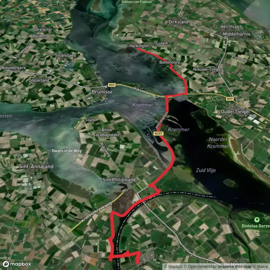
You’ll be walking a classic lowland “dike-and-waterworks” line from West Brabant/Tholen’s polder edge to the Grevelingenmeer at Herkingen—flat, open, and wind-shaped. At ~26 km (16.2 mi) with ~0 m (0 ft) of climbing, the effort is mostly about distance, exposure to weather, and long straight sections rather than hills. Plan on 5.5–7 hours of moving time depending on pace and stops.
Start location (nearest landmark/address): Nieuw-Vossemeer village center, near the Voorstraat / Dorpsstraat area by the Dutch Reformed Church (Hervormde Kerk) and close to Molen Assumburg (Assumburg windmill)—both are prominent, easy-to-find landmarks in town. (en.wikipedia.org)
Finish location (nearest landmark/address): Herkingen Haven (harbor) area, near the marina on the Grevelingenmeer. (moovitapp.com)
Getting to the start (car + public transport)
- By car: Nieuw-Vossemeer is straightforward to reach via regional roads around Steenbergen/Tholen. Parking is typically easiest on village streets near the center (look around the church/windmill area) or near the dike edges where local parking bays exist—be mindful not to block farm access.
- By public transport: Rural Zeeland/West Brabant services can be infrequent and vary by day. A practical approach is to route by train to a larger hub (e.g., Roosendaal or Bergen op Zoom) and continue by regional bus/taxi. For the most reliable, current options, check the Dutch journey planner (9292) and match it with your HiiKER track timing so you’re not forced to rush the last kilometers.
Getting back from the finish (Herkingen)
Herkingen is served by regional buses that connect toward Middelharnis (a key transfer point on Goeree-Overflakkee). One commonly listed service is Connexxion line 738 between Herkingen and Middelharnis, with stops including Herkingen, Haven. Verify the day/time carefully because rural lines may run mainly on weekdays and at low frequency. (moovitapp.com)
If you’re doing this as a point-to-point hike, the simplest logistics are:
- two cars (spot one at Herkingen Haven), or
- bus from Herkingen toward Middelharnis, then onward connections, or
- a pre-booked taxi from Herkingen if you finish late.
You’ll leave Nieuw-Vossemeer on quiet lanes and farm tracks through reclaimed polder land—wide skies, long sightlines, and drainage canals that run ruler-straight. The first 6–8 km (3.7–5.0 mi) are typically a rhythm-builder: flat surfaces, occasional farm traffic, and very little shade. In wet periods, expect muddy edges on unpaved sections; in dry spells, the same tracks can be dusty and exposed.
Nieuw-Vossemeer itself has a layered water-history that fits the landscape you’re walking through. The village originated after land was poldered in the 1500s, was deliberately inundated in 1583 during the Eighty Years’ War to hinder the Spanish Army, and later rebuilt around 1610. It was also badly affected by the North Sea flood of 1953, a disaster that still shapes how this region thinks about dikes and storm protection. (en.wikipedia.org)
As you progress, the route’s character becomes increasingly “engineered waterland.” You’ll likely spend long stretches on or near dikes—excellent for visibility and easy walking, but fully exposed to wind. In this part of the Netherlands, wind is the real “elevation”: a headwind can make an easy 26 km feel surprisingly long.
The Krammer / Philipsdam / Krammersluizen section (major landmark + what to expect)
Around the middle of the hike (often roughly 12–18 km / 7.5–11.2 mi in, depending on your exact line), you reach the standout feature: the Philipsdam and Krammersluizen complex—part of the Delta Works system. (rijkswaterstaat.nl)
This is where the walk turns into a front-row

Surfaces
Asphalt
Unknown
Grass
Comments and Reviews
User comments, reviews and discussions about the NieuwVossemeer to Herkingen via Krammer, Netherlands.
average rating out of 5
0 rating(s)