Download
3D Flyover
Add to list
More
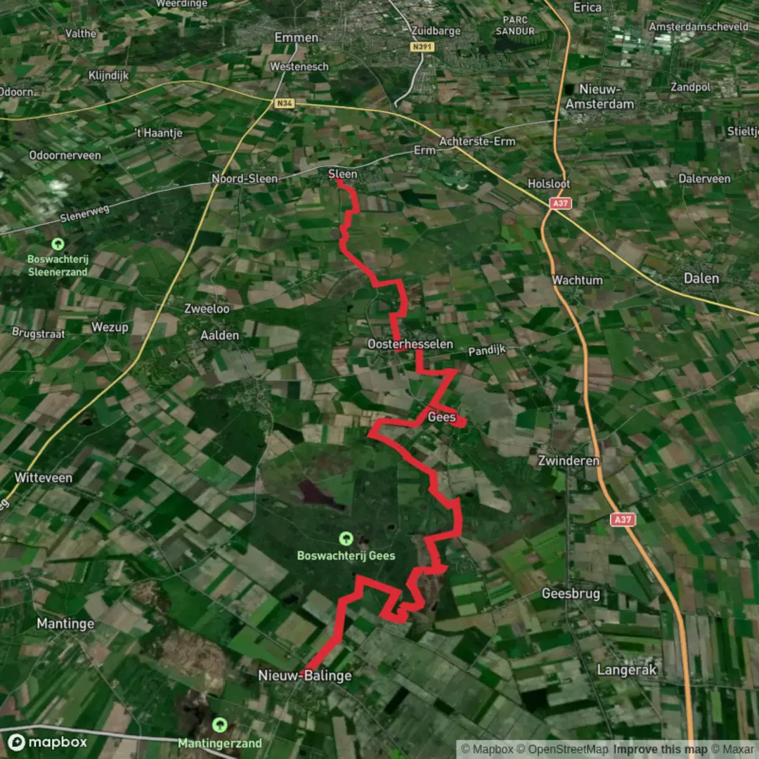
23.6 km
~4 hrs 43 min
8 m
Point-to-Point
“Wander from esdorp lanes into Gees’s heath-and-vennen wilds, where flat paths feel quietly epic.”
You’ll be walking through classic southeast-Drenthe countryside: quiet farm lanes between esdorpen (old ridge-top villages), long straight forestry tracks, and then a surprisingly wild-feeling core around Boswachterij Gees—a mosaic of deciduous woodland, heath, and pools (vennen). At roughly 24 km / 15 miles with about 0 m / 0 ft of climbing, the effort is mostly about time on feet, surface conditions, and staying oriented through a web of sandy forest roads.
Start and finish landmarks (practical, easy to find)
- Start (Nieuw-Balinge): aim for the village center around Nieuw-Balinge (postcode area 7938), Midden‑Drenthe, near the local church area (Nieuw‑Balinge is a small village; the “center” is the most reliable meetup point if you’re coordinating rides).
- Finish (Sleen): the natural endpoint is Sleen village center (brink/green and services area), where you’ll find amenities and onward connections.
Getting to the start (car + public transport)
By car - Nieuw-Balinge sits in Drenthe, roughly 10 km / 6 mi northeast of Hoogeveen. Parking is typically easiest on public village streets near the center—arrive early if you want a stress-free spot.
By public transport - In this part of Drenthe, buses are the realistic option (rail is in the larger towns). Plan your door-to-trail timing with HiiKER plus the local bus planner, because rural routes can be infrequent and vary by day/season. If you’re doing this as a point-to-point, it’s often simplest to bus to one end and bus back from the other.
What the route feels like underfoot
Expect a mix of: - Village pavements and quiet asphalt lanes leaving Nieuw-Balinge. - Hard-packed forest roads (often wide, straight) as you enter managed woodland. - Sandy stretches in drier periods—easy terrain, but it can slow your pace. - Damp/narrower paths near water and low meadows around the Gees area; after rain, some sections can be soft or muddy.
Even with “flat” elevation, the surfaces can make this feel longer than the numbers suggest. A steady all-day pace for most hikers is often 5–6 hours moving time, plus stops.
Through Boswachterij Gees: heath, woodland, and water
Boswachterij Gees is the centerpiece: a quieter Drenthe forest area threaded with heath fields and many vennen. The landscape here was shaped heavily by 20th-century forestry—parts of the deciduous woodland were planted in the 1930s to help stabilize drifting sand, which is why you’ll notice long, purposeful lines in some stands of trees. (drenthe.nl)
Wildlife you’re likely to notice
This is a strong area for birds and wetland-edge wildlife:
- The vennen are known habitat for ducks, geese, and swans. (drenthe.nl)
- Heath and edge habitats can support reptiles including grass snakes (ringslangen) and adders—they’re not looking for trouble, but watch where you place hands/feet on sunny path edges and heather margins. (drenthe.nl)
- You may encounter Scottish Highland cattle used for grazing management (they help keep young trees from taking over the heath). Give them space, don’t thread between animals, and especially avoid approaching calves. (drenthe.nl)
If your timing overlaps with winter or migration periods, the broader Gees/Mepper meadows are also known for high bird activity, with pools and open grassland attracting many species. (birdingplaces.eu)
A standout landmark: Mekelermeer (Ice Age geology)
One of the most significant natural landmarks you can pass near is the Mekelermeer, a large ven that’s also a pingoruïne—a remnant landform from the last Ice Age (Weichselian), recognized as an important piece of Dutch geological heritage. It’s notable because it has remained open water rather than turning into peat, preserving a long environmental record in its sediments. (drenthe.nl)
If your line takes you close

Surfaces
Unknown
Asphalt
Concrete
Sand
Dirt
Grass
Comments and Reviews
User comments, reviews and discussions about the Nieuw Balinge to Sleen via Boswachterij Gees, Netherlands.
average rating out of 5
0 rating(s)