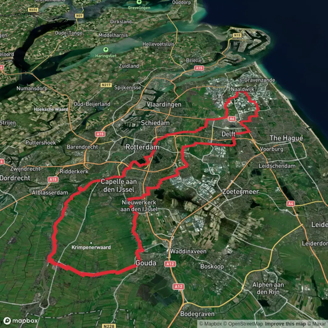
Kenenburgpad, Vlakoverpad, Delftweg, Kleinpolderkade and Oosteinde Loop
Download
3D Flyover
Add to list
More
122.8 km
~5 days
6 m
Multi-Day
“A wind-swept polder loop of canals, dikes, and windmills—flat underfoot, long on focus.”
This is a long, lowland loop through the Dutch “polder” landscape—canals, dikes, pasture, windmills, and village edges—where the challenge is almost never climbing, but distance, wind exposure, and staying oriented through a dense web of paths, cycleways, and water crossings. At ~123 km (about 76 mi) with roughly ~0 m (0 ft) of elevation gain, it’s physically “easy” in terrain but demanding in time-on-feet. Most hikers treat it as a 2–4 day outing (or a very long ultra-style day).
Getting to the start (public transport + car)
Because the start is listed only as “near,” the most practical way to pin it down is to use the first named segment as the anchor. Kenenburgpad is associated with the Kenenburg area in Schipluiden/Den Hoorn (South Holland)—a well-known local place-name tied to the historic Kenenburg estate area. A reliable “meet-up” landmark that’s easy to navigate to is:
- Schipluiden (near Kenenburg / Keenenburgweg area), South Holland — close to the village center and the network of dike paths and canals that connect toward Den Hoorn, Delft, and the Rotterdam fringe.
By public transport (from Rotterdam or The Hague):
- Take a train to Delft (major hub), then a regional bus toward Schipluiden / Den Hoorn. From the bus stop in/near Schipluiden village center, you can walk a short distance to the first dike/canal paths.
- If you’re coming from Rotterdam, you can also route via Delft or Schiedam depending on bus connections that day.
By car: - Aim for parking near Schipluiden village center (look for public parking by local facilities) or on the edge of town where day-parking is permitted. Avoid blocking farm access roads and dike maintenance gates—these are actively used.
For navigation, plan to load the full loop in HiiKER and download offline maps; the area has many near-identical junctions and parallel paths along canals.
What the route feels like (terrain, surfaces, and pacing)
Expect almost continuous flat travel on: - Dike-top paths (often narrow, sometimes grassy or compacted) - Paved cycleways (fast, efficient, but shared with cyclists) - Farm access lanes (gravel, concrete slabs, or asphalt) - Canal-side towpaths (can be muddy after rain)
Even with “0 m” climbing, you’ll get frequent micro-undulations over bridges, locks, and dike ramps—small but constant. Over 123 km (76 mi), those little ramps add up in leg fatigue.
Pacing guidance (typical walking):
- 4–5 km/h (2.5–3.1 mph) moving pace on flat surfaces
- Add time for gates, bridge crossings, photos, food stops, and navigation checks
A single-day attempt can easily become 24–30+ km (15–19 mi) before it feels like you’ve “made a dent,” so plan your resupply and daylight carefully.
Landmarks, landscape, and the “why” of this place
This loop stitches together place-names that read like a cross-section of South Holland’s engineered landscape:
- Kenenburgpad: Near the historic Kenenburg estate area around Schipluiden/Den Hoorn—this region sits in the old cultural landscape of estates, farms, and managed waterways.
- Vlakoverpad: Typically indicates a local path across open, level ground—expect wide skies, long sightlines, and very little shelter.
- Delftweg: A road/route pointing toward Delft, the historic canal city famous for its Golden Age heritage, Delftware, and ties to the House of Orange. Even if you only skirt the outskirts, you’ll feel the transition from rural polder to urban edge.
- Kleinpolderkade: “Kade” signals a dike/embankment; “polder” signals reclaimed/managed land. This is classic water-management country—straight canals, pumping infrastructure, and long dike lines.
- Oosteinde: Often a village-edge or neighborhood name (“east end”), commonly marking older settlement lines along higher ground or along a dike.
Historically, this whole region is defined by land reclamation and water control—polders drained and maintained by a system of canals, dikes, and pumping (once wind-driven, now largely mechanical). The landscape is “flat” because it’s built to be: water levels are regulated, fields are graded, and drainage is continuous.
Nature and wildlife to look for
Despite the agricultural setting, the canal network and wet meadows can be lively:
Birdlife (most noticeable): - Waterfowl along canals and ditches (ducks, geese, swans) - Meadow and marsh birds in open pasture and reed edges - Raptors scanning fields (often seen perched on poles)
Mammals and small wildlife: - Rabbits and small rodents along dike edges - Frogs and fish in the ditches and canals (especially in warmer months)
Seasonal notes: - Spring and early summer bring the most bird activity. - After heavy rain, towpaths can become slick; grassy dikes can turn into a narrow, muddy balance-beam.
Navigation and route-finding (flat doesn’t mean simple)
This is the kind of route where people get “lost” without ever feeling lost

Surfaces
Asphalt
Unknown
Sand
Concrete
Wood
Paved
Grass
Gravel
Comments and Reviews
User comments, reviews and discussions about the Kenenburgpad, Vlakoverpad, Delftweg, Kleinpolderkade and Oosteinde Loop, Netherlands.
average rating out of 5
0 rating(s)