Download
3D Flyover
Add to list
More
10.6 km
~2 hrs 7 min
7 m
Loop
“A gentle island loop through pine-sheltered hollows and windswept dunes, where big skies steal the show.”
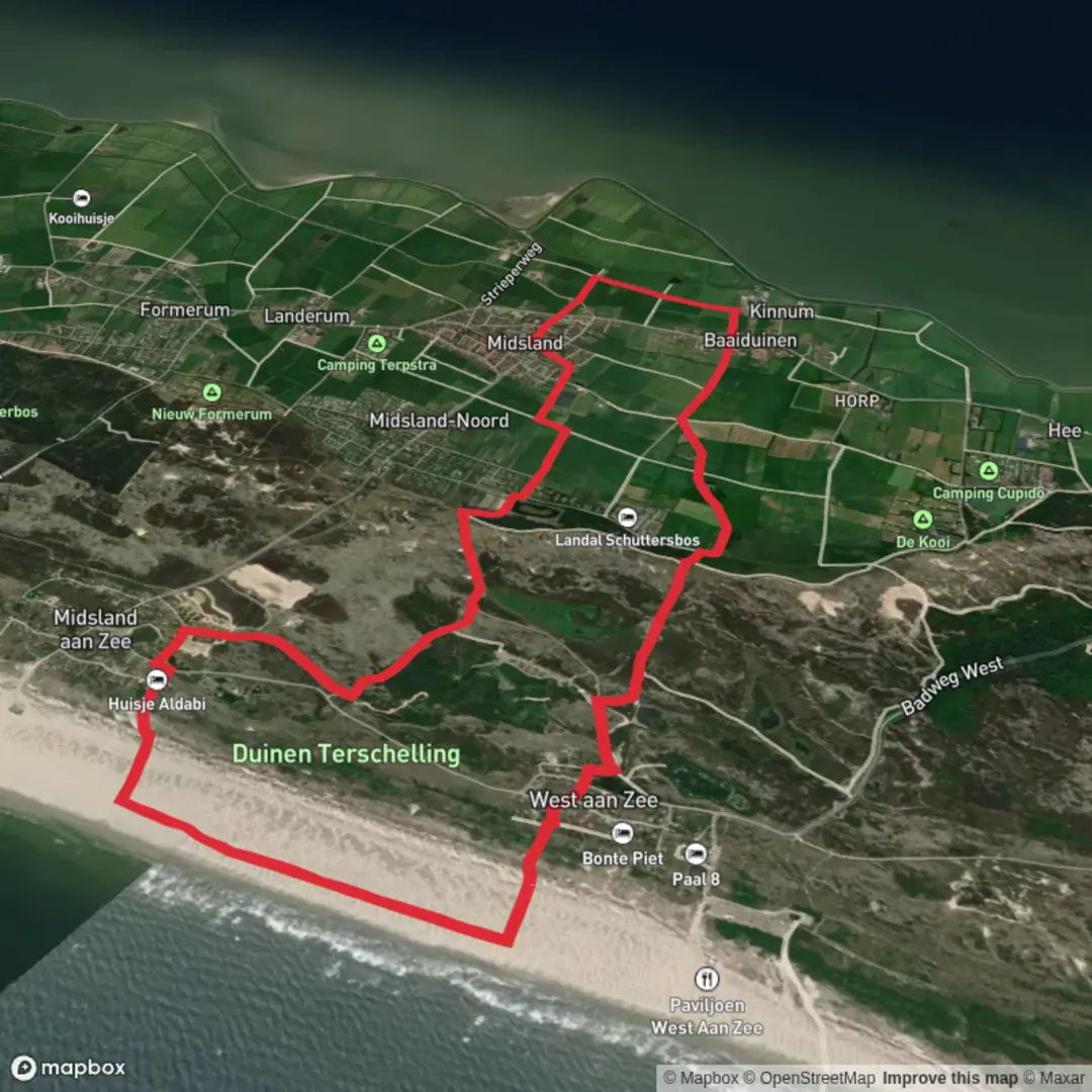
This easy, mostly level loop of about 11 km (6.8 mi) explores a classic cross-section of Terschelling: sheltered woodland and heath around a freshwater depression, then open dune country with big skies and shifting sands. Expect negligible elevation gain—roughly 0–20 m (0–65 ft) of gentle ups and downs depending on the exact dune lines you follow and wind-shaped trail conditions.
Where the hike starts (and what “near” likely means)
The route name points to the Peerekuil area and the Duinen van Terschelling (Terschelling dunes). A practical, well-known place to begin is near West-Terschelling, close to the island’s main arrival point at the Veerhaven (ferry terminal) and the village center. If you’re using HiiKER, match the start pin to the nearest signed access point for Peerekuil or a marked dune/forest trailhead on the west side of the island; on Terschelling, trail access is typically via clearly signed sandy paths and cycle-track crossings rather than a single “official” parking lot.
If you share the start coordinates (lon/lat), I can convert them to the nearest named trail access, street, or landmark on Terschelling.
Getting to the start
By public transport - Train + bus + ferry: Most visitors come via Harlingen Haven (mainland). From there, take the ferry to West-Terschelling. On arrival, you can usually walk or take a local bus toward trail access points around the west end of the island. The island is very bike-friendly, and renting a bike near the harbor is common if you want to shorten the road-walk to the trailhead. - On-island buses: Terschelling has bus service along the main village line (West-Terschelling → Midsland → further east). Choose a stop closest to the west-end dune/forest access indicated by HiiKER.
By car - Drive to Harlingen Haven and park in long-stay lots near the ferry terminal (you generally don’t need a car on Terschelling). Take the passenger ferry to West-Terschelling and start from the harbor area or a nearby trail access point. - If you do bring a vehicle over (where permitted/available), parking is typically easier near village edges and signed recreation areas; follow local signage and avoid blocking cycle paths.
What the trail is like underfoot
You’ll alternate between: - Firm forest paths (often compacted sand or fine gravel) - Sandy dune tracks that can be soft and energy-sapping in dry or windy weather - Short connectors near cycle paths or quiet access lanes
Because the loop is nearly flat, the main “effort variable” is sand and wind exposure, not climbing. After rain, low spots can hold water; after dry spells, dunes can feel slower than the distance suggests.
Route flow and key landmarks (approximate)
Distances below are approximate for an ~11 km (6.8 mi) loop; your exact split will vary with the chosen connectors shown in HiiKER.
0.0–2.5 km (0.0–1.6 mi): Woodland edge and sheltered tracks You’ll ease in on protected paths where Scots pine and mixed coastal woodland break the wind. This section is ideal for settling into a steady pace before the sandier terrain. Look for small clearings and low, damp hollows—these are often where you’ll notice more bird activity.
2.5–5.5 km (1.6–3.4 mi): Peerekuil area—freshwater depression and heathy margins “Kuil” in Dutch place names often refers to a hollow or pit-like depression; in dune landscapes these can become freshwater ponds or wet slacks. Around Peerekuil, expect a change in vegetation: heather, grasses, and moisture-loving plants in lower ground, with slightly higher, drier edges transitioning back to scrub and woodland. - Wildlife to watch for: songbirds in the scrub, waterfowl or waders if there’s open water, and plenty of insect life in warmer months. In dune-heath mosaics, you may also spot rabbits and signs of fox. - Footing note: edges of wet slacks can be muddy; stay on the main tread to avoid trampling sensitive plants and to keep your shoes dry.
5.5–8.5 km (3.4–5.3 mi): Open dunes—Duinen van Terschelling This is the most “island” feeling part of the loop: rolling dunes, open horizons, and the constant reshaping influence of wind. Even without big elevation numbers, short dune rises can add a bit of pulse. - Wind exposure: expect stronger gusts and wind chill here. A calm start near the village can turn into a blustery mid-loop. - Navigation: dune paths can braid and rejoin. Use HiiKER to confirm you’re staying on the intended line, especially where multiple sandy tracks diverge.
8.5–11.0 km (5.3–6.8 mi): Return through mixed terrain The final stretch typically threads back toward more sheltered ground—often faster walking on firmer surfaces. If your loop returns toward West-Terschelling, you may pass near cultural landmarks depending on the exact alignment.
Nature, wildlife, and seasonal considerations
- Birdlife: Terschelling sits within

Surfaces
Sand
Unknown
Asphalt
Ground
Grass
Gravel
Comments and Reviews
User comments, reviews and discussions about the Peerekuil and Duinen Terschelling Loop, Netherlands.
average rating out of 5
0 rating(s)