Download
3D Flyover
Add to list
More
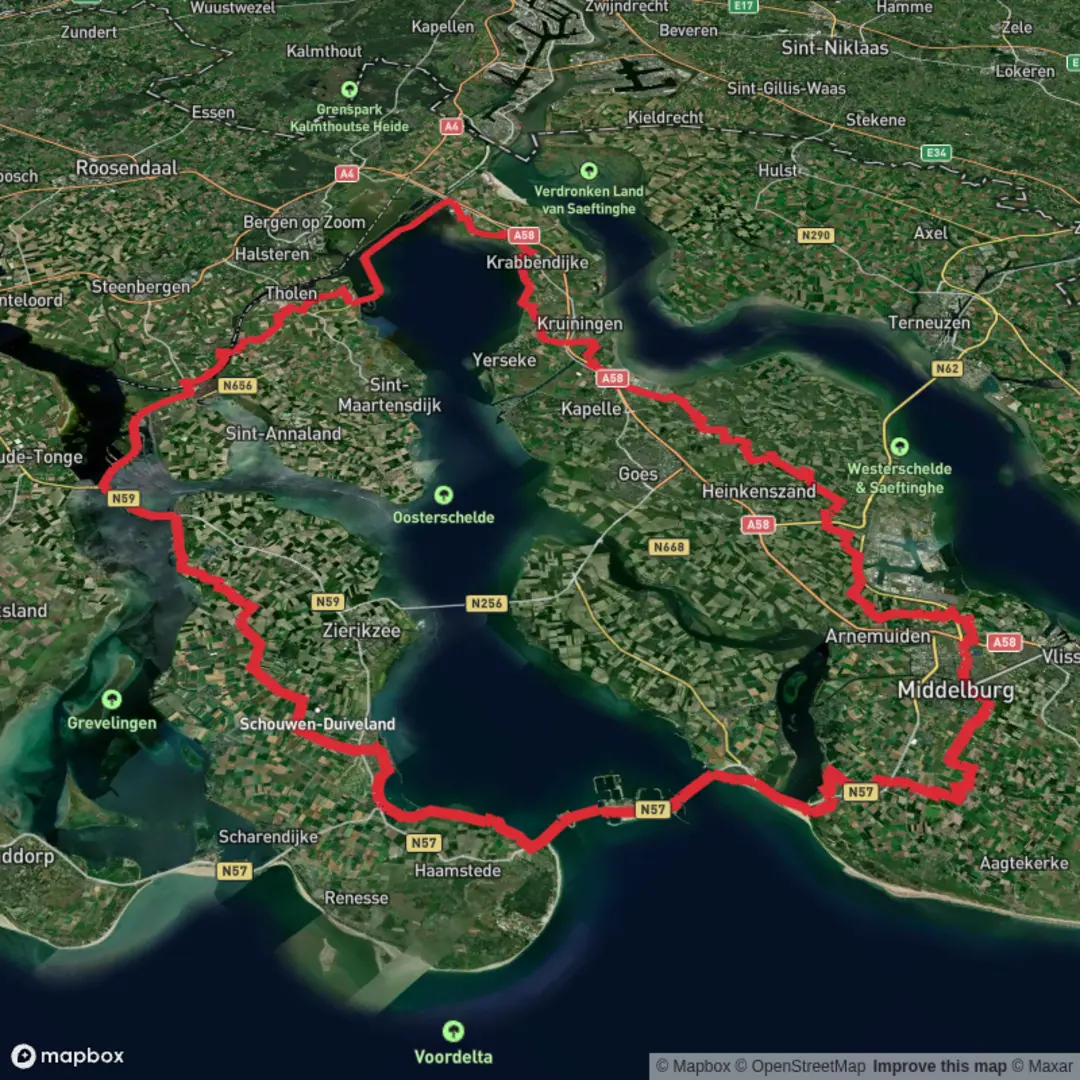
169.6 km
~6 days
68 m
Multi-Day
“A windswept Zeeland loop of dikes and polders—big skies, saltmarsh light, and deceptively long days.”
This is a long, low-relief coastal-and-polder loop of roughly 169 km (105 mi) with only about 100 m (330 ft) of total climbing—so the challenge is less about hills and more about wind exposure, long distances between services in places, and staying oriented across dikes, causeways, and farmland tracks. Expect a mix of sea defenses (dikes), wide estuary views, saltmarsh edges, reclaimed land (polders), small Zeeland villages, and long straight walking lines that can feel deceptively “easy” until the mileage adds up.
For a practical starting point near the route, a common, easy-to-find landmark in the area is Goes railway station (Stationsplein, Goes, Zeeland)—a major public-transport hub on Zuid-Beveland and a sensible place to stage logistics (food, water, lodging) before stepping onto dike paths and rural lanes.
Getting to the start (public transport + car)
By train/bus:
- Travel by train to Goes Station (intercity/regional connections via Roosendaal toward Zeeland). From there, local buses and short taxi rides can position you closer to whichever trailhead segment you’re using to begin the loop.
- If you’re splitting the hike into sections, Zeeland’s rail spine (e.g., Goes/Middelburg/Vlissingen) plus buses to smaller villages makes it feasible to “leapfrog” stages without needing two cars.
By car:
- Zeeland is well-served by the A58 corridor. Parking is typically easiest near larger towns (again, Goes is convenient) or at signed public car parks near village centers. In smaller dike-side areas, be careful: many narrow lanes are farm access routes—park only where clearly permitted and never block gates.
What the terrain feels like
Although the elevation gain is tiny, the walking surface changes constantly:
- Dike-top paths: often paved or compacted, very exposed to wind; great visibility but little shelter.
- Farm tracks and rural lanes: can be hard-packed gravel, asphalt, or muddy after rain.
- Causeways and estuary edges: open, sometimes with long straight stretches that can be mentally tiring.
- Village connectors: short urban/residential segments where you can resupply.
Because the route is so flat, headwinds can be the biggest “climb.” Plan your daily distances with that in mind—25–35 km (15–22 mi) per day is realistic for many hikers on flat ground, but strong coastal wind can make 25 km (15 mi) feel like a big day.
Navigation and wayfinding (keep it simple)
This is the kind of landscape where you can see “forever,” yet still miss turns because everything looks similar—parallel dikes, straight farm roads, and repeating drainage canals. Use HiiKER to: - confirm you’re on the correct dike/causeway (there may be multiple parallel options), - spot upcoming villages for water/food, - identify bail-out points to bus stops or larger towns if weather turns.
Landmarks, scenery, and the character of the region
You’re walking through the heart of Zeeland’s delta landscape, shaped by tides, storms, and centuries of engineering. The “big picture” landmarks are often not single monuments but the waterworks themselves—dikes, sluices, and managed shorelines that keep the polders dry.
Delta engineering and historical context
This region is inseparable from the Netherlands’ long history of living with water. Zeeland’s islands and peninsulas have been repeatedly reshaped by storm surges and land reclamation. The modern coastline and many of the robust defenses you’ll walk atop are part of a broader story of flood protection and delta management—a landscape where “nature” and “infrastructure” are tightly interwoven. Even when you’re simply striding along a grassy embankment, you’re often on top of a structure that represents generations of communal water management.
Estuary views, saltmarsh edges, and big skies
Along the Oosterschelde side, expect: - wide tidal waters with changing light and strong currents, - mudflats and saltmarsh fringes (depending on where the loop runs closest to the shore), - constant bird activity and a strong sense of openness.
On clear days, the horizon can feel enormous; on grey days, the same openness can feel stark—pack layers accordingly.
Nature and wildlife to look out for
This is prime territory for coastal and estuarine birdlife. Depending on season and exact shoreline access, you may see: - waders and shorebirds feeding on tidal flats (look for groups probing mud at low tide), - geese and ducks in wetter fields and near inlets, - raptors (often seen quartering over open farmland), - hares and rabbits along dike slopes and field margins.
A few practical notes: - Bring binoculars if you enjoy wildlife—this is a “watch from afar” landscape. - Stay on marked paths near sensitive shore zones; some areas have seasonal restrictions to protect roosting or nesting birds. - Ticks can be present even in open country where grass is long—do checks after walking dike-top vegetation.
Weather, exposure, and comfort planning
With so little elevation, the main environmental factors are:
- Wind: sustained coastal wind can be draining and can chill you quickly when damp.
- Rain: flat farmland tracks can become slick; waterproof footwear helps, but breathability matters for long days.
- Sun: there can be long

Surfaces
Unknown
Asphalt
Concrete
Paved
Grass
Sand
Comments and Reviews
User comments, reviews and discussions about the Oosterscheldepad and Zandvoortseweg Loop, Netherlands.
average rating out of 5
0 rating(s)