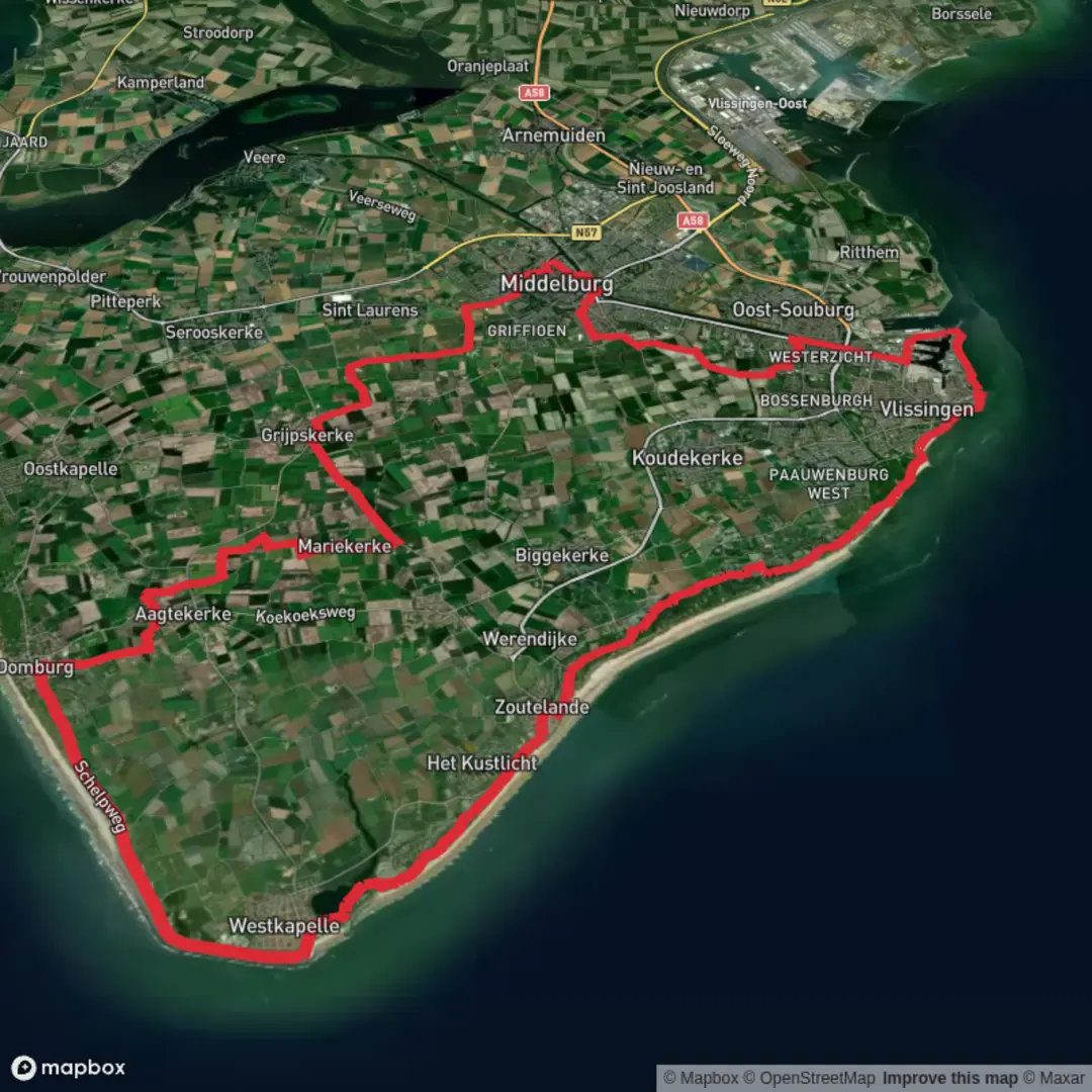
Binnenhaven, Groot Valkenisse and Westkapelsche via Vlissings Jaagpad and Strand Zoutelande
Download
3D Flyover
Add to list
More
52.4 km
~2 days
0 m
Multi-Day
“From harbor bustle to canal calm to dune‑lined sea, a wind‑shaped, steady long walk.”
This is a long, flat coastal-and-canal day that links three very different “Waters of Walcheren”: the working harbor basins of Vlissingen, the straight, engineered Canal through Walcheren, and the open North Sea shoreline with dunes, dikes, and the Westkapelse Kreek. At ~52 km (32.3 mi) with ~0 m (0 ft) of climbing, the challenge is almost entirely about time-on-feet, wind exposure, and keeping your pace steady on hard surfaces.
Start point (nearest landmark/address): the Binnenhaven / inner-harbor area of Vlissingen (Flushing)—practically, the easiest “pin” for planning is Vlissingen Station (Station Vlissingen), since it’s a clear arrival point and close to the harbor-side walking network. (en.wikipedia.org)
Key waypoints you’ll recognize en route: the Vlissings Jaagpad along the canal corridor toward Middelburg, the dune-and-beach zone around Groot Valkenisse (near Biggekerke), Strand Zoutelande (often signed from the village), and the Westkapelse Kreek nature area by Westkapelle. (holland-cycling.com)
Getting to the start (public transport + car)
- By train (simplest): take Dutch Railways services to Vlissingen Station, the western end of the Roosendaal–Vlissingen line. From the station, you can walk toward the harbor basins to pick up the Binnenhaven area and connect to the canal-side paths. (en.wikipedia.org)
- By car: aim for parking around central Vlissingen/harbor districts (signed “Haven”/“Centrum”). For a 52 km (32.3 mi) route, many hikers prefer a point-to-point plan (car at finish + bus/taxi back) or a loop that returns to Vlissingen via the coast.
Expect a very “Dutch” feel: excellent path surfaces, frequent signage, and lots of cyclists—especially on the canal corridor and coastal promenade sections.
What the walking feels like (surface, exposure, pacing)
Most of the day is on paved multi-use paths, compacted gravel, and dike-top tracks. True sand walking is optional depending on whether you choose to step onto the beach near Zoutelande/Valkenisse; staying on the dune paths and promenade keeps it fast and consistent.
- Wind is the main difficulty multiplier. Walcheren is open and coastal; a headwind can turn an “easy” flat 52 km into a grind. Plan layers you can vent, and consider a slightly slower target pace than you’d use inland.
- Foot care matters on flat, hard ground. With minimal elevation change, repetitive loading is the issue—cushioned socks, shoes you trust for long pavement stretches, and a blister plan are more important than “mountain” gear.
Route flow and approximate distances (for planning)
Because this is a long linear-style itinerary with multiple named segments, it helps to think in legs. Distances below are approximate so you can plan breaks and resupply:
Leg 1: Vlissingen Binnenhaven → canal corridor (Vlissings Jaagpad)
~0–12 km (0–7.5 mi), ~0 m (0 ft) gain
You’ll leave the harbor basins and settle onto the canal-side alignment. “Jaagpad” historically refers to towpaths where horses (or people) pulled barges—today it’s a straight, efficient corridor that’s popular for cycling and walking. (pzc.nl)
What to watch for:
- Fast cyclists and commuting traffic—hold a predictable line, especially on bends and at bridge approaches.
- Limited shelter: if the wind is up, this section can feel surprisingly exposed.
Leg 2: Canal corridor → dunes near Groot Valkenisse (Biggekerke area)
~12–28 km (7.5–17.4 mi), ~0 m (0 ft) gain
As you angle back toward the coast, the landscape shifts from engineered waterway to dune edges and seaside infrastructure. Groot Valkenisse is essentially a coastal hamlet area near Biggekerke; you’ll notice holiday parks/camping and beach access points as you approach. (chaletaandezeeuwsekust.nl)

Surfaces
Unknown
Asphalt
Concrete
Paved
Gravel
Cobblestone
Comments and Reviews
User comments, reviews and discussions about the Binnenhaven, Groot Valkenisse and Westkapelsche via Vlissings Jaagpad and Strand Zoutelande, Netherlands.
average rating out of 5
0 rating(s)