Download
3D Flyover
Add to list
More
32.1 km
~6 hrs 27 min
14 m
Point-to-Point
“Follow canals from Meppel into heath and pine hush, ending in Steenwijk’s waterside calm.”
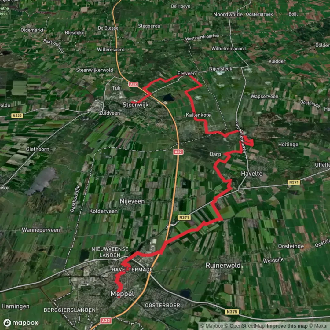
This is a long, mostly flat point‑to‑point walk across Drenthe into Overijssel, linking canal-side town walking with heathland, pine forest, and quiet rural paths. At roughly 32 km / 20 mi with about 0 m / 0 ft of total ascent, it’s best planned as an all‑day outing where your main challenges are distance, surfaces (pavement vs. sand), and staying oriented through forest sections rather than hills.
Getting to the start (Meppel) + where to begin
Nearest obvious start landmark: Meppel railway station (Station Meppel) and the adjacent town-center canals (the old inner harbor area is a natural “trailhead” zone with services).
- By train (public transport): Meppel is a major rail stop in the northern Netherlands, with frequent connections via Zwolle and onward to the Randstad. From the station you can walk straight into the canal district and pick up quiet streets and towpaths.
- By car: Aim for parking near Station Meppel or one of the central car parks close to the canal ring. Starting near the station is practical because you’ll likely finish in Steenwijk, which also has a station for an easy return.
Finish logistics: Steenwijk railway station is the most convenient end landmark. If you’re doing this as a one-way hike, the simplest plan is: train to Meppel, hike to Steenwijk, train back.
What the route feels like underfoot
Expect a mix of: - Town paving and brick paths leaving Meppel and entering Steenwijk - Canal and drainage-ditch edges (often firm, sometimes muddy after rain) - Forest tracks around Havelterberg (generally wide, sandy in places) - Heath and open sandy patches where wind can make it feel cooler than the temperature suggests
Even with minimal elevation gain, the day can feel long because flat terrain encourages a steady pace—plan breaks so you don’t “bank” fatigue for the final 8–10 km (5–6 mi).
Segment-by-segment expectations (approximate)
0–6 km (0–3.7 mi): Meppel out to the countryside You’ll leave the canal townscape and transition quickly into quieter edges—small roads, farm lanes, and water management landscapes typical of Drenthe. Look for classic Dutch lowland features: straight drainage lines, reed margins, and open fields. Birdlife is often the first highlight here: grey heron, mallard, coot, and various gulls are common, with seasonal chances of geese and waders in wetter plots.
6–18 km (3.7–11.2 mi): Havelterberg area—forest and heath This is the most “nature-forward” portion. Havelterberg sits in a region shaped by ice-age processes and later human land use, so you’ll notice sandy soils, pine plantations, and heathland openings rather than broadleaf forest. The walking can alternate between firm forest road and softer sand.
What to look out for - Heathland edges: In late summer, heather can color the landscape; in other seasons it’s more muted but still open and airy. - Wildlife: Expect roe deer possibilities at dawn/dusk, plus buzzards overhead. In forested stretches you’ll often hear great spotted woodpecker and other songbirds. - Surface changes: Sandy sections can slow you down; if it’s been dry, sand can be loose; if it’s been wet, some forest tracks hold puddles.
Historical significance in this zone Drenthe is known for prehistoric remains and ancient land use patterns. Around Havelterberg and nearby heath/forest complexes, the broader region contains prehistoric burial monuments (hunebedden/dolmens) and traces of early settlement typical of Drenthe’s archaeological landscape. Even when you’re not directly passing a monument, the “old land” feel—heath, sandy ridges, and long-used tracks—reflects that deep history.
18–26 km (11.2–16.2 mi): Toward De Bult—quiet rural connectors As you angle toward De Bult, the route tends to feel more transitional again: a blend of woodland margins, small roads, and agricultural edges. This is where pacing matters—many hikers feel the distance here because the scenery becomes subtly repetitive.
Practical notes - Wind exposure: Open farmland can be breezy; bring a light shell even on mild days. - Limited services: Outside towns and villages, assume few cafés/shops. Carry enough water and food for several hours.
26–32 km (16.2–20 mi): De Bult into Steenwijk De Bult is a small settlement area on the approach to Steenwijk. From here you’ll gradually re-enter more built-up surroundings. Steenwijk has a historic core and is a gateway town to the wider wetland landscapes of the region (including areas associated with De Weerribben-Wieden nearby), so you may notice more waterways and managed green spaces as you close in.
Navigation (use HiiKER)
This is a straightforward lowland route, but the forest and track networks around Havelterberg can create “parallel path” confusion where multiple sandy lanes run close together. Use HiiKER to: - Confirm you’re on the correct forest track at junction clusters - Check distance-to-go so you can time breaks (especially after ~18 km / 11 mi) - Identify nearby public transport points if you need to shorten the day
Difficulty, timing, and

Surfaces
Asphalt
Unknown
Sand
Concrete
Grass
Gravel
Ground
Comments and Reviews
User comments, reviews and discussions about the Meppel to Steenwijk via Havelterberg and De Bult, Netherlands.
average rating out of 5
0 rating(s)