Download
3D Flyover
Add to list
More
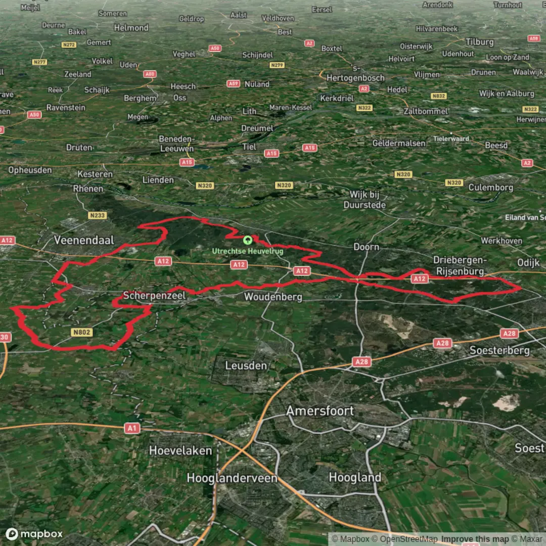
81.3 km
~3 days
201 m
Multi-Day
“A long, gentle wander through Heuvelrug forests and heath, where soft sand tests stamina.”
This is a long, low-relief tour through the heart of the Utrechtse Heuvelrug—a sandy ridge of forests and heathland that rises gently above the surrounding Dutch lowlands. At around 81 km (50 mi) with roughly 200 m (656 ft) of total ascent, the climbing is never hard, but the distance makes it a full-day endurance hike for most people (or a very comfortable 2-day outing).
Where the hike starts (nearest landmark / address)
“Hoog Kanje” is a street and area on the east side of Zeist. A practical, easy-to-find start point near the Hoog Kanje area is Station Driebergen–Zeist, Oude Stationsweg 2, 3972 KA Driebergen-Rijsenburg (common access point to the Zeisterbos and Heuvelrug trail network). (postcode.site)
If your GPX start pin is actually inside the Hoog Kanje neighborhood itself, a nearby reference address is Hoog Kanje 186, 3708 DL Zeist (medical practice on Hoog Kanje, useful as a “known” map label). (huisartspraktijkhoogkanje.uwartsonline.nl)
Getting to the start
- By public transport: Take the train to Driebergen–Zeist station. From the station forecourt you can walk straight into the woods and connect to the wider Heuvelrug path network. (visitheuvelrug.com)
- By car: Aim for parking near the Driebergen–Zeist station area (paid/regulated depending on exact lot), or use one of the larger recreation car parks once you’re on the ridge (these vary by municipality and season).
What the terrain is like (and why it feels “easy”)
Expect a lot of wide forest tracks, sandy paths, and compacted shell/gravel-style surfaces—especially where the route overlaps with the Let de Stigterpad, which is known for long, smooth segments that avoid the worst roots and holes. (komoot.com)
“Easy” here mostly means:
- no steep grades (the Heuvelrug’s “hills” are short and rounded),
- straightforward footing for long stretches,
- frequent access points to towns/roads if you need to shorten the day.
What can still make it feel harder: - soft sand in dune-like sections (notably around Kanje/Zeisterbos-type soils), - long, straight forest lanes that can be mentally tiring, - wet periods turning some sandy tracks into churned, puddled corridors.
Route character and key sections (approximate breakdown)
Because this loop stitches together named segments (Hoog Kanje, Maarnseberg/Maarnse Berg, Let de Stigterpad, Postweg), it helps to think of it as four big “moods”:
1) Hoog Kanje / Zeist-side woods: rolling forest and inland “dunes” (≈ 0–18 km / 0–11 mi)
Early on you’re in classic central-Netherlands woodland: mixed stands of pine and deciduous trees, with sandy underfoot and occasional open patches where the ridge’s wind-blown sands show through. This is where you’ll often notice the Heuvelrug’s geology most clearly—subtle rises, shallow bowls, and dry, fast-draining soils.
Landmarks tend to be understated here: forest junctions, long lanes, and the occasional clearing. Navigation is easiest if you keep a close eye on your HiiKER track at intersections—many paths look equally “main.”
What to look out for: - MTB crossings: the Heuvelrug is a major cycling area; expect fast riders at trail junctions and on shared forest roads. - Sand patches: they can slow pace and increase calf fatigue over an 81 km day.
2) Toward

Surfaces
Asphalt
Unknown
Concrete
Unpaved
Gravel
Paved
Sand
Ground
Comments and Reviews
User comments, reviews and discussions about the Hoog Kanje, Maarnseberg, Let de Stigterpad and Postweg Loop, Netherlands.
average rating out of 5
0 rating(s)