Download
Preview
Add to list
More
12.6 km
~2 hrs 32 min
13 m
Loop
“Wander through blooming heather, sandy dunes, and tranquil ponds on this gentle loop near Luyksgestel.”
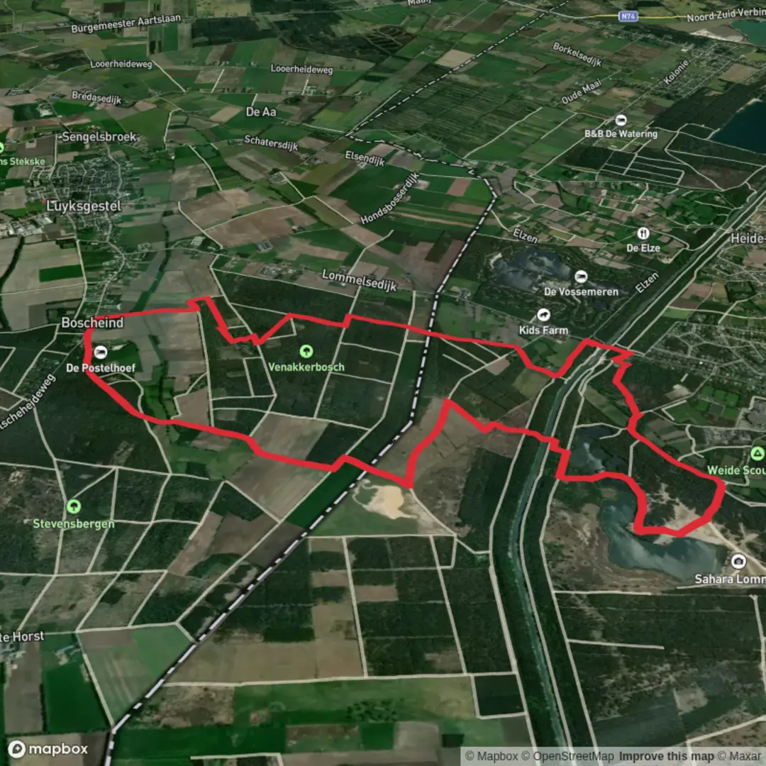
Starting from the outskirts of Luyksgestel, a small village in the southern Netherlands, this 13 km (about 8 miles) loop trail offers a gentle, flat walk with virtually no elevation gain, making it accessible for hikers of all abilities. The trailhead is conveniently located near the intersection of Provincialeweg and Bosscherweg, just a short distance from the village center.
Getting There
Luyksgestel is accessible by regional bus from Eindhoven or Valkenswaard, with the nearest bus stop being “Luyksgestel, Kerk,” about a 10-minute walk from the trailhead. For those arriving by car, parking is available near the Bosscherweg, close to the edge of the forested area where the loop begins.
Trail Overview and Navigation
The route forms a broad loop through a patchwork of heathland, pine forests, and tranquil ponds. Navigation is straightforward, with well-marked paths and clear signage at major junctions. For those seeking extra confidence, the entire loop is mapped on HiiKER, which provides GPS navigation and offline maps.
Key Sections and Landmarks
Bosscherweijer and Heathland
The first section leads you through the Bosscherweijer, a serene area characterized by sandy soil and scattered pine trees. The landscape here is typical of the Kempen region, shaped by centuries of grazing and peat extraction. At around 2 km (1.2 miles), you’ll notice the terrain open up into heathland, especially vibrant in late summer when the heather blooms in purple hues. Keep an eye out for skylarks and the occasional roe deer darting through the undergrowth.
Sahara and Zwartven
At approximately 5 km (3 miles), the trail skirts the edge of the “Sahara,” a local nickname for a stretch of open sand dunes. This unique landscape was formed by wind erosion after historical deforestation and is now a rare habitat for sand lizards and ground-nesting birds. Shortly after, you’ll reach Zwartven, a peaceful pond surrounded by reeds and birch trees. This is a great spot for a break, with benches offering views over the water where dragonflies and frogs are abundant in spring and summer.
Woodland and Return
The final section of the loop winds through mixed woodland, with tall Scots pines and occasional clearings. The forest floor is carpeted with moss and, in autumn, dotted with mushrooms. Birdlife is rich here, including woodpeckers and nuthatches. The path eventually brings you back toward the starting point near Bosscherweg.
Historical and Natural Significance
The Kempen region, where this loop is located, has a long history of land use dating back to medieval times. The sandy soils were once considered poor for agriculture, leading to the preservation of large tracts of heath and woodland. The ponds and wetlands, such as Zwartven, were often created for peat extraction or as watering holes for livestock. Today, these habitats are protected for their biodiversity and scenic value.
Facilities and Preparation
There are no major facilities directly on the trail, but Luyksgestel village offers cafés, a bakery, and restrooms. The flat terrain and well-maintained paths mean standard walking shoes are sufficient, though waterproof footwear is advisable after rain. Bring water and snacks, as there are limited opportunities to resupply along the route.
This loop is ideal for a relaxed day out, with plenty of opportunities to enjoy the quiet beauty of the Dutch countryside and observe local wildlife.

Surfaces
Unknown
Dirt
Sand
Ground
Gravel
Grass
Unpaved
Asphalt
Concrete
Wood
Comments and Reviews
User comments, reviews and discussions about the Bosscherweijer, Sahara and Zwartven Loop, Netherlands.
average rating out of 5
0 rating(s)