Download
3D Flyover
Add to list
More
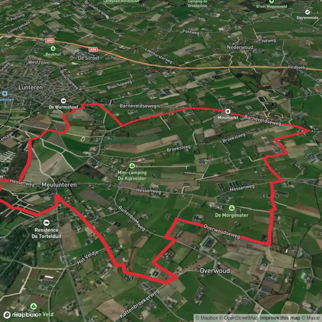
14.4 km
~2 hrs 53 min
15 m
Loop
“A mostly level Meulunteren loop drifts through Veluwe woods, heath whispers, sandy tracks and farm lanes.”
This easy, mostly level loop of about 14 km (8.7 miles) wanders through a classic patchwork of Veluwe-edge woodland, heath remnants, sandy tracks, and agricultural lanes around the Meulunteren area. With an estimated ~0 m (0 ft) of total climbing, it’s a great choice for a relaxed half-day walk where the main “effort” is distance rather than elevation—expect firm forest paths, wide gravel tracks, and a few short stretches of quiet road or farm access lanes.
Getting to the start (car + public transport)
Because the hike head is listed only as “near” (no coordinates provided), the most practical way to plan is to aim for the Meulunteren / De Valk area (municipality of Ede, Gelderland, Netherlands)—a common access point for the Meulunterensche Veld and nearby forest blocks.
- By car: Navigate to Meulunteren (near Ede) and look for parking at or near a forest access point such as the Meulunteren woods / Veluwe forest edge. In this region, parking is typically at small pull-ins or signed forest car parks near main access roads; confirm the exact trailhead parking in HiiKER before you go so you start on the correct side of the loop.
- By public transport: The nearest major rail hub is Ede-Wageningen station. From there, local buses commonly run toward villages like Meulunteren (service patterns can vary by day/time). Plan the last-mile connection (bus stop to trailhead) in advance and use HiiKER to align the loop start with the closest stop.
If you share the lon/lat for the hike head, I can convert it to the nearest known address or landmark and tighten the transport/parking guidance to a specific spot.
What the route feels like underfoot - Surface mix: Mostly wide forest tracks and compacted gravel, with occasional sandy sections (common on the Veluwe) that can feel softer after dry spells. - Seasonal conditions: After rain, low-lying forest stretches can hold puddles; in late summer, sandy parts can be loose and dusty. - Footwear: Light hiking shoes are usually enough; choose something with a bit of tread if it’s been wet.
Along the loop: landscape, landmarks, and what to notice
Over roughly 14 km (8.7 miles), the character tends to alternate between quiet conifer and mixed woodland and more open edges where you’ll see fields, hedgerows, and straight farm lanes. The “Veld” in the name points to the area’s historic open-ground character—parts of the Veluwe were long shaped by grazing, sod-cutting, and heath management, leaving a legacy of open patches, sandy soils, and managed forest compartments.
- First 3–5 km (1.9–3.1 miles): Expect a gentle warm-up on broad tracks through managed woodland. Look for mossy verges, bracken, and the clean lines of forestry rides. These straight corridors can feel similar—keep an eye on junctions and confirm turns with HiiKER.
- Middle 5–10 km (3.1–6.2 miles): This is often where the loop’s variety shows up: transitions between darker conifer stands and lighter mixed woodland, plus occasional openings that hint at heath or former open ground. If the route passes near “De Driesingel,” the name suggests a three-hedge/three-belt landscape feature—a nod to the region’s long agricultural history of field boundaries, shelterbelts, and windbreaks.
- Last 4 km (2.5 miles): Typically a calm return through forest edge and lanes. If you’re walking near farms, you may encounter short paved stretches—easy walking, but stay alert for local traffic (often cyclists, farm vehicles, and residents).
Nature and wildlife (what you might see) This part of Gelderland sits close to the Veluwe’s well-known habitats. Wildlife sightings are never guaranteed, but the setting is favorable:
- Mammals: Roe deer are common at woodland edges, especially early/late in the day. The broader Veluwe region is also known for wild boar; if you see rooting in sandy soil or churned leaf litter, that’s a clue they’ve been active.
- Birdlife: Expect woodland staples—great spotted woodpeckers, jays, tits, and in quieter stands you may hear buzzards overhead. Open edges can bring finches and other farmland birds.
- Plants: Sandy soils support heather remnants, bilberry in places, and a lot of pine and mixed plantation forestry. In spring and early summer, forest margins can be rich with wildflowers; in autumn, fungi can be prolific along damp verges.
What to look out for (easy route, but a few practical hazards) - Navigation at forestry junctions: Straight, similar-looking tracks can make it easy to miss a turn. Keep HiiKER handy and double-check at every multi-track intersection. - Soft sand patches: Even without elevation gain, sand can slow your pace. If you’re aiming for a time window, budget a little extra. - Ticks: Woodland edges and grassy verges can carry ticks in warmer months. Long socks, repellent, and a post-hike check are sensible. - Shared-use paths: You may meet cyclists on wider tracks. Hold a predictable line and listen for bells.
Planning notes

Surfaces
Unknown
Asphalt
Sand
Paved
Ground
Unpaved
Comments and Reviews
User comments, reviews and discussions about the Meulunterensche Veld and De Driesingel Loop, Netherlands.
average rating out of 5
0 rating(s)