Download
3D Flyover
Add to list
More
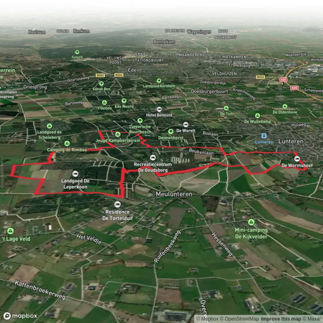
12.2 km
~2 hrs 28 min
20 m
Loop
“Wander Lunteren’s pine-and-heath lanes to the Netherlands’ “middle,” where sand, mud, and ancient traces linger.”
You’ll be walking on the central Veluwe near Lunteren (municipality of Ede, Gelderland)—a famously flat-to-gently-rolling mix of pine woods, sandy tracks, heath edges, and quiet estate lanes. For an “easy” 12 km (about 7.5 mi) loop with roughly 0 m / 0 ft of meaningful elevation gain, expect more “soft underfoot” than “steep,” with the main challenges being sand, mud after rain, and a few confusing forest junctions where it helps to have HiiKER ready.
Getting to the start (car + public transport)
A practical place to begin is by Landgoed De Leperkoen, Vijfsprongweg 25, 6741 JA Lunteren (a well-known local landmark and address on the edge of the woods). (bezoek-ede.nl)
- By car: Drive toward Lunteren and follow signs for the Vijfsprongweg area; parking is typically easiest around the estate/nearby forest pull-ins along Vijfsprongweg (availability varies by day and season).
- By train + bus/walk: Lunteren has its own railway station on the Amersfoort–Ede/Wageningen line. From the station you can connect by local bus/taxi, or walk if you don’t mind adding distance. (en.wikipedia.org)
What the route feels like underfoot
This loop is mostly forest paths and sandy forestry roads with occasional firmer estate lanes. In dry spells, some stretches can turn into loose, energy-sapping sand; after wet weather, the low spots can hold standing water and become slick. Footwear with decent tread is more important than ankle support here—think “traction in sand and mud,” not “mountain boot.”
Because the terrain is subtle, it’s easy to drift onto the wrong parallel track in the pines. Keep an eye on junction density and confirm turns with HiiKER, especially where multiple straight sandy lanes intersect.
Key landmarks and worthwhile detours
Landgoed De Leperkoen and the Veluwe estate landscape
Starting near De Leperkoen puts you immediately into classic Veluwe scenery: managed woodland blocks, quiet clearings, and long straight tracks that hint at centuries of land use and forestry. The estate is also a convenient “services anchor” (a recognizable start/finish point) in an otherwise path-heavy forest matrix. (bezoek-ede.nl)
Lindeboomsberg and the “Middelpunt van Nederland”
One of the most distinctive stops in this area is Lindeboomsberg, known for the “Middle of the Netherlands” marker—an outdoor monument-like setting that draws walkers for photos and a quick breather. The site has a modern landscape design treatment (rings/arena concept) that makes the “center point” feel like a destination rather than just a stone in the woods. (lunterseboer.nl)
If your loop passes close, it’s worth the short spur: it’s flat, easy, and breaks up the forest walking with a clear landmark.
Prehistory on the Veluwe: Celtic fields and the Germaanse Put
This region is unusually rich in visible traces of ancient land use:
- Celtic fields (raatakkers): low earthen banks outlining small ancient plots—subtle, but once you “see” the grid, it’s memorable. They’re generally dated to the Iron Age / around 400 BC in many local descriptions. (dutch-guide.com)
- De Germaanse Put: a partly preserved hollowed tree-trunk well dated (via C14 in local interpretation) to around 300 BC, tied to early farming settlement in the area. (lunteren.nl

Surfaces
Unknown
Sand
Unpaved
Ground
Asphalt
Grass
Paved
Comments and Reviews
User comments, reviews and discussions about the De Leperkoen and Lindeboomsberg Loop, Netherlands.
average rating out of 5
0 rating(s)