Download
3D Flyover
Add to list
More
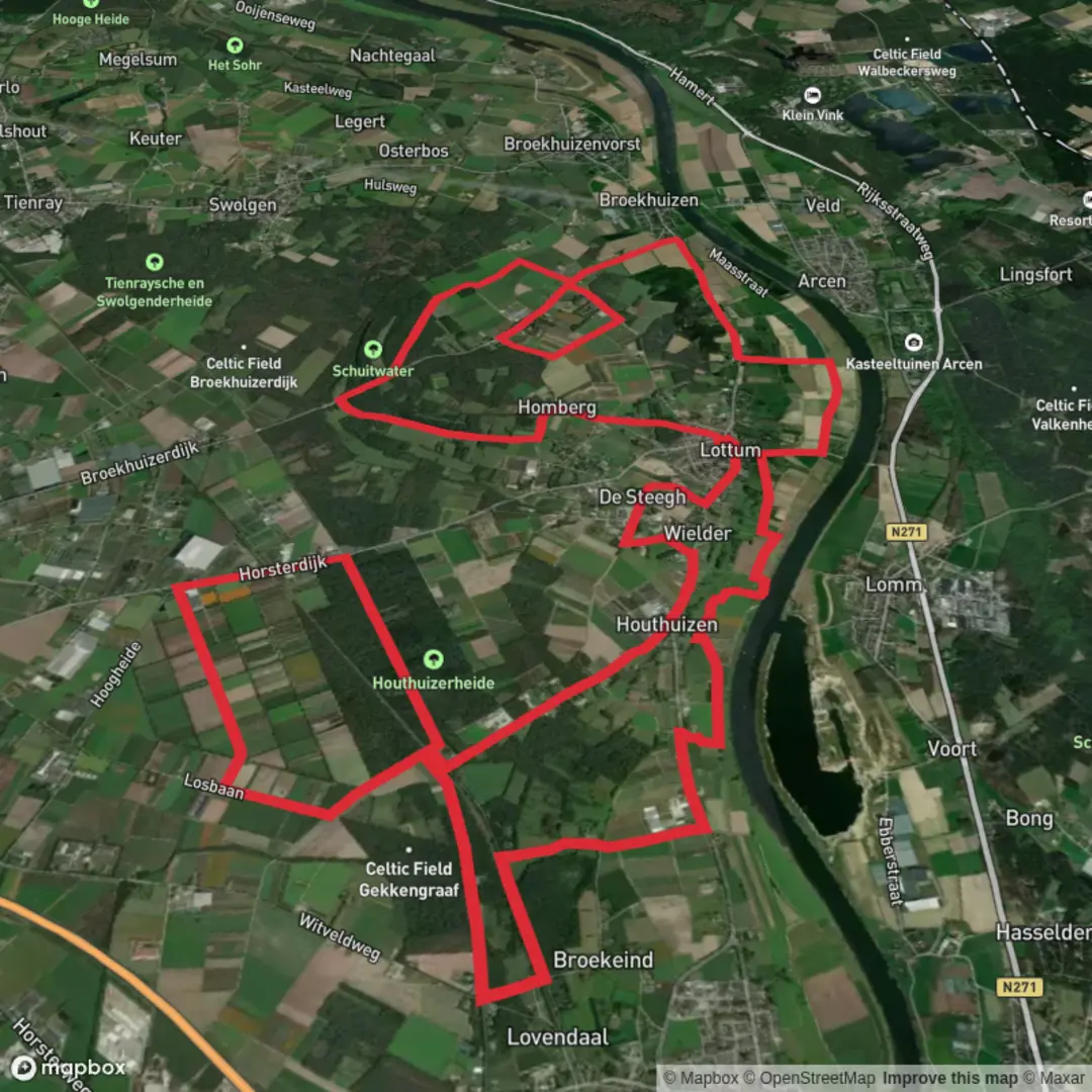
31.2 km
~6 hrs 13 min
0 m
Loop
“A flat, big-sky loop through forest hush and heather sands—steady, but the distance quietly tests you.”
This is a long, low-relief loop of roughly 31 km (19.3 mi) with essentially 0 m (0 ft) of climbing—classic “big day on flat ground.” Expect a mix of quiet forest tracks, sandy heathland paths, and long, straight rural lanes where your pace can be steady but the distance sneaks up on you. Because the terrain is so flat, the main challenges are time on feet, surface changes (sand vs. firm track), and staying oriented at frequent junctions.
Getting to the start (car + public transport)
Because the start point is listed only as “near” (no coordinates provided), the most practical way to plan is to anchor your start at a recognizable access point close to the named features:
- Best “known landmark” to aim for: the Houthuizerheide / Houthuizerheide-area trail access near Lottum / Grubbenvorst (Limburg, Netherlands). This region sits in North Limburg near the Maas (Meuse) corridor and is commonly accessed via small parking pull-ins and forest/heath entrances rather than a single formal trailhead.
- By car: Navigate to a parking area or trail access near Lottum or Grubbenvorst, then use HiiKER to snap to the exact loop start on Vonkelsebosweg/Houthuizerheide-side tracks. Roads here are typically narrow; park only in designated pull-offs to avoid blocking farm/forestry access.
- By public transport: The most reliable approach is usually train to Venlo (major rail hub in the area), then a regional bus toward Grubbenvorst / Lottum, finishing with a short walk to the forest/heath edge. Use HiiKER to choose a start point within walking distance of the bus stop you select, since stops vary by route and day.
If you share the loop’s coordinates (or a HiiKER link), I can pin the nearest specific address/parking area precisely.
What the route feels like underfoot - Surface: mostly hard-packed forest track, gravel, and paved farm lanes, with intermittent sandy stretches on heath edges. After dry spells, sand can slow you down; after rain, some forest sections can hold shallow puddles. - Gradient: effectively flat. Any “ups and downs” are micro-undulations, track camber, or small embankments. - Effort: Easy by steepness, but moderate by duration. Many hikers will take 6–8+ hours depending on pace and breaks.
First third (0–10 km / 0–6.2 mi): Forest lanes and quiet edges
You’ll likely begin on or near Vonkelsebosweg, which reads like a typical Dutch forest road: straight lines, tidy verges, and frequent side tracks. Early on, it’s easy to walk too fast because the footing is forgiving—save your legs for the later sandy/heath sections.
Look out for: - Forestry junction density: multiple track crossings can look similar. Keep HiiKER handy and confirm you’re on the correct branch before committing to a long straight. - Drainage ditches: common along forest roads; they’re not dangerous, but they can limit where you can step off-trail for breaks.
Nature notes: - Expect mixed woodland and managed forest blocks with songbirds in the canopy and woodpecker activity in older stands. - In quieter hours you may spot roe deer at the margins where forest meets open fields.
Middle section: Heathland character and big-sky walking (10–22 km / 6.2–13.7 mi)
As you transition toward Houthuizerheide, the landscape typically opens up. Heathland in this part of the Netherlands is shaped by centuries of human use—grazing, cutting, and later conservation management—creating a mosaic of heather, grasses, sandy patches, and scattered pines/birch.
What to expect: - More exposure to wind and sun than in the forest. On a flat route, weather can be the biggest variable—bring a light shell even on “nice” forecasts. - Sandy segments: these can be short but energy-sapping. If you feel your calves working harder, shorten your stride and keep cadence steady. - Long sightlines: great for navigation confidence when landmarks are visible, but junctions can still be subtle where narrow paths braid through low vegetation.
Wildlife and seasonal highlights: - Late summer often brings heather color and increased insect activity; consider repellent and a light long-sleeve if you’re sensitive. - Heath edges can host rabbits, buzzards/kestrels hunting over open ground, and occasional fox sightings at dawn/dusk.
Final third (22–31 km / 13.7–19.3 mi): Return via rural lanes and forest re-entry
The last portion often strings together the most efficient lines back—farm roads, straight forest corridors, and the familiar feel of managed woodland. This is where the “easy” rating can feel deceptive: flat terrain doesn’t force rests, so fatigue accumulates quietly.
Practical things to watch for: - Cyclists and local traffic: even quiet lanes can have fast-moving bikes. Walk single-file on narrow paved sections. - Foot care: on long flat hikes, hotspots form from repetition. If you feel rubbing by ~20 km (12+ mi), stop and address it immediately—tape beats blisters. - Monotony management: long straightaways can dull attention;

Surfaces
Unknown
Asphalt
Paved
Gravel
Sand
Unpaved
Comments and Reviews
User comments, reviews and discussions about the Vonkelsebosweg and Houthuizerheide Loop, Netherlands.
average rating out of 5
0 rating(s)