Download
3D Flyover
Add to list
More
41.6 km
~2 days
76 m
Point-to-Point
“A meandering Dinkel daydream: sandy riverbanks, whispering pines, and meadow-breeze miles for steady walkers.”
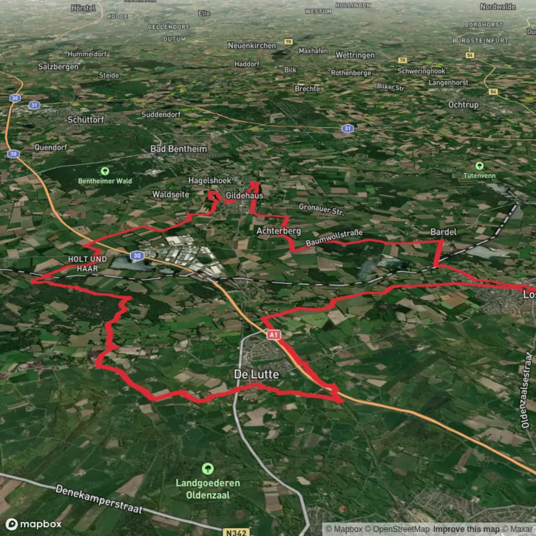
This is a long, low-relief riverside loop through one of the most scenic corners of Twente, where the Dinkel River has carved sandy banks and small bluffs into the landscape. At roughly 42 km / 26 mi with only about 100 m / 330 ft of total ascent, it’s physically more about time on feet than climbing—ideal if you want an all-day walk with constant variety: heath and pine, oak-beech woodland, open meadows, and the distinctive “sand step” riverbanks around Lutterzand.
Getting to the start (and what “near” usually means here)
Because the start point wasn’t fully specified, most hikers begin this route from the Lutterzand recreation area on the Dinkel River, just east of De Lutte (Overijssel, Netherlands). The most recognizable landmark to aim for is Lutterzand (Dinkel valley nature area)—often accessed via the local roads between De Lutte and Losser.
- By car: Navigate (with HiiKER for the final approach) toward Lutterzand / De Lutte and use the signed recreation-area parking near the Dinkel. In this region, parking is typically at or near the main Lutterzand access points (look for signage for “Lutterzand” and “Dinkel”).
- By public transport: The nearest practical hubs are Oldenzaal and Enschede (both have rail connections). From there, buses run toward De Lutte and surrounding villages; the last stretch is commonly a short taxi ride or a longer walk-in. If you want the cleanest logistics, plan to arrive in De Lutte and walk to the river access.
If you share the exact lon/lat for the trailhead, I can pin it to the nearest named road/parking area or landmark and describe the first kilometer precisely.
What the terrain feels like over 42 km / 26 mi
Expect mostly flat to gently rolling walking on a mix of: - Packed forest paths and sandy tracks (some sections can be soft underfoot) - Riverside footpaths that narrow and undulate slightly where the Dinkel cuts into the sand - Farm lanes and field-edge paths around Molenveld
Even with only ~100 m / 330 ft of ascent total, you’ll notice frequent micro-ups and downs along the riverbanks—short, easy rises rather than sustained climbs. After rain, the Dinkel-side paths can be muddy and the sand can turn slick, especially on the little cutbanks and rooty steps.
Lutterzand and the Dinkel: the signature section
Within the first third of the day (often by 5–12 km / 3–7.5 mi, depending on your exact start), the route typically settles into the Dinkel valley character that makes Lutterzand famous: meandering water, steep sandy edges, and mixed woodland. The river here is not a big, roaring channel—it’s intimate and winding, which means: - Frequent views through trees to the water - Short spurs and bends where the “best path” can be ambiguous—use HiiKER to stay on the intended line when multiple footpaths braid together - Occasional erosion scars where the bank has slumped; give edges space, especially if you’re walking with kids or in wet conditions
Wildlife is one of the highlights. You’re in a classic lowland river corridor, so keep an eye out for: - Kingfishers (a flash of electric blue close to the water) - Herons and other waders in calmer stretches - Roe deer at woodland edges early/late in the day - A busy soundtrack of woodland birds in spring and early summer
Molenveld and the quieter middle miles
The “via Molenveld” portion usually shifts you away from the river’s immediate edge into a more open, rural mosaic—think meadows, hedgerows, and small woodlots. This is where the hike can feel mentally easier (less navigation complexity) but physically more repetitive if the wind is up.
Plan for the middle section—roughly 15–30 km / 9–19 mi—to be where you manage: - Pacing and fueling (it’s easy terrain, so people often start too fast) - Exposure on open tracks (sun or wind) - Foot comfort if you’ve had long sandy stretches earlier
If the route passes any of the area’s traditional mill sites (the name “Molenveld” hints at historic milling landscapes), you may see remnants of older rural infrastructure—field patterns, drainage lines, and farmsteads that reflect centuries of land use in Twente. This region sits close to the Dutch–German border and has long been shaped by agriculture, small settlements, and trade routes rather than dramatic mountain geography.
Navigation, services, and practical planning for an “Easy” 42 km / 26 mi
“Easy” here means low elevation and non-technical, not short. For most hikers, 42 km is a full-day commitment.
Time planning - Typical moving time: 8–10.5 hours depending on pace and stops. - Start early to avoid finishing the last hour in fading light, especially outside summer.
Water & food - Treat this as a route where you should carry what you need between villages. Even if you pass cafés or shops near De Lutte/Losser, opening hours can be limited. - Bring enough water for long stretches; top

Surfaces
Asphalt
Unknown
Paved
Concrete
Cobblestone
Sand
Unpaved
Wood
Comments and Reviews
User comments, reviews and discussions about the Lutterzand via Molenveld, Netherlands.
average rating out of 5
0 rating(s)