Download
3D Flyover
Add to list
More
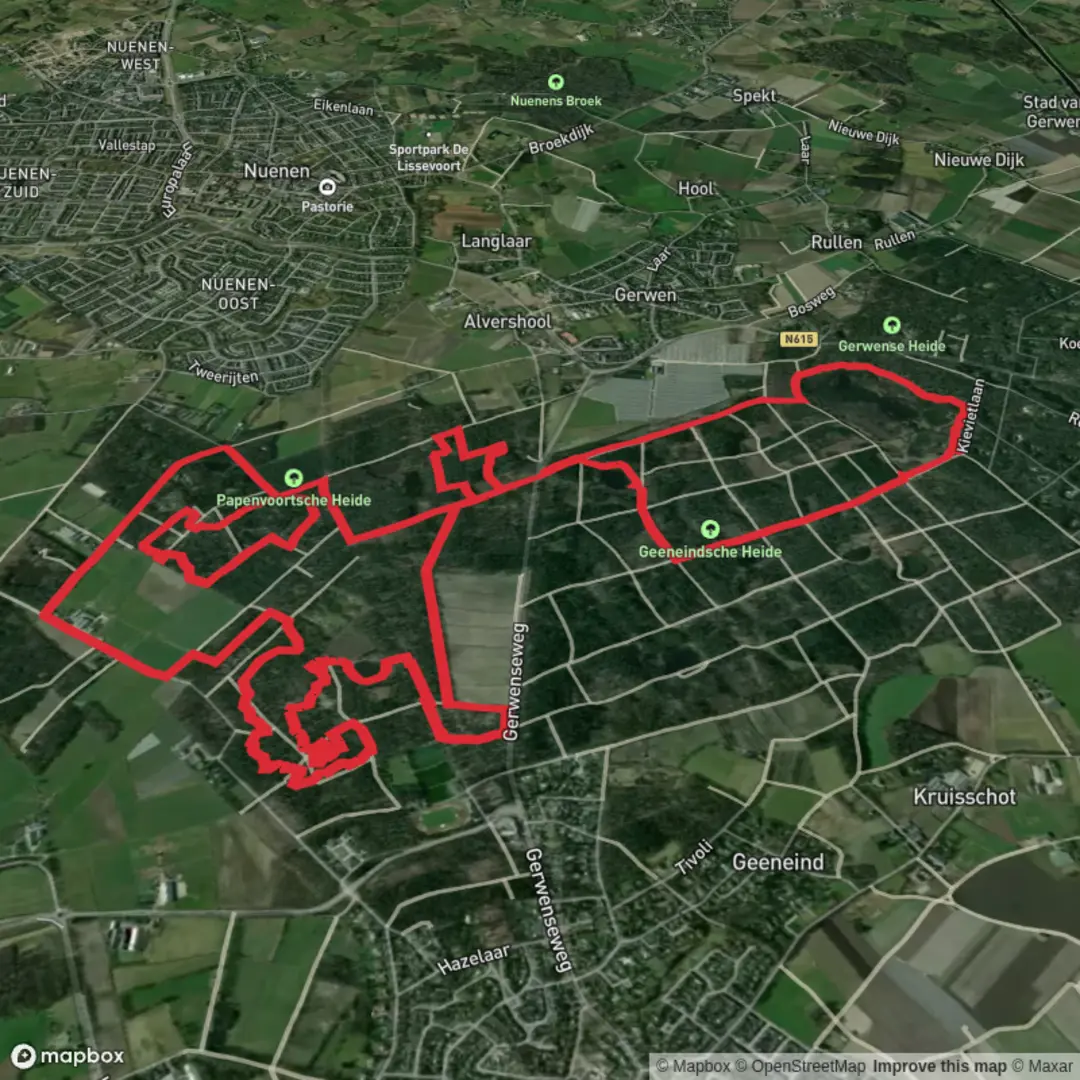
15.9 km
~3 hrs 11 min
0 m
Loop
“A gentle heath-and-forest loop of big skies, soft sand, and quiet lanes—best savoured unhurried.”
This is a gentle, mostly level loop of about 16 km (10 miles) with roughly 0 m (0 ft) of climbing—ideal for a relaxed half-day walk on sandy paths, heathland tracks, and quiet forest lanes. Expect easy footing overall, with the main “effort” coming from soft sand in places and the occasional muddy stretch after rain rather than any hills.
Getting to the start (car + public transport)
Because the start point is listed only as “near” (no coordinates or town provided), the best I can do is describe the usual access pattern for this area and what to look for once you share a pin:
- By car: These loops in the Geeneindsche / Papenvoortsche Heide / Zandbergen area are typically started from a small forest/heath parking pull-in near a signed nature access point (often marked as a parkeerplaats). If you send the start lon/lat, I’ll convert it to the nearest named road, parking area, or landmark and tell you exactly where to park and which side of the road the trailhead signage is on.
- By public transport: In this part of the Netherlands, the most common approach is train to the nearest larger station, then a regional bus to a village-edge stop, followed by a 1–3 km (0.6–1.9 mi) walk to the heath/forest access. If you share the start coordinates (or even the nearest village name), I can point to the most practical station + bus stop pairing and the simplest walk-in route.
If you’re planning navigation, load the loop on HiiKER and download it for offline use—this landscape can have many similar-looking sandy junctions where it’s easy to take the “right-looking” track that’s actually parallel to your route.
What the terrain feels like (and what to wear)
You’re moving through classic lowland heath-and-woodland country: flat, open heath patches alternating with pine and mixed woodland, plus occasional edges of farmland or forestry rides. Underfoot you’ll likely see: - Sandy single/double track (can be energy-sapping even when flat) - Firm forest paths with pine needles - Short sections of heathland boardwalk or hardened trail (where management protects fragile vegetation) - After wet weather: puddled hollows and dark, peaty mud in low spots
Footwear: light hiking shoes are fine in dry conditions; after rain, water-resistant trail shoes help. Bring a wind layer—open heath can feel cooler than the forest even on mild days.
Route flow and key waypoints (approximate)
Because the loop name references three distinct areas, the walk usually breaks naturally into thirds. Distances below are approximate for a 16 km (10 mi) circuit:
0–4 km (0–2.5 mi): Woodland approach and sandy tracks
You’ll likely start on a broad access path that quickly narrows into a web of sandy forestry tracks. This early section is where people most often drift off-route—multiple junctions can look identical. Keep an eye out for heathland edges opening up ahead; that transition is a good confirmation you’re moving toward the more open Papenvoortsche Heide landscape.
4–10 km (2.5–6.2 mi): Papenvoortsche Heide—open heath, big skies
This is the signature middle of the loop: low, open heath with scattered trees and long sightlines. In late summer, heather can color the ground in muted purples; in other seasons it’s more about texture—dry grasses, sandy patches, and the contrast between open heath and dark conifers.
Wildlife is often most visible here because of the openness:
- Roe deer may appear at the heath/forest boundary, especially early or late in the day
- Raptors (buzzards, kestrels) often hunt over open ground
- Ground-nesting birds can be present seasonally—stay on the main path where signage requests it
If you encounter fenced areas or temporary diversions, they’re usually for habitat restoration (heath management often involves controlled grazing, scrub removal, or protecting regenerating areas).
10–16 km (6.2–10 mi): Zandbergen—quieter forest return
The final third typically returns you into more enclosed woodland. The walking becomes more sheltered and steady, often on straighter forestry lines. This is where you may notice subtle changes in forest type—denser pine blocks versus mixed stands—and occasional clearings from forestry work. Even though the elevation gain is essentially negligible, the last few kilometers can feel longer if you hit deeper sand; a slightly slower pace here is normal.
Nature, wildlife, and seasonal notes
- Heathland ecology: Heath is a managed habitat in much of the Netherlands—without intervention it tends to revert to woodland. The mosaic you’ll see (open heath, scrubby edges, forest blocks) reflects long-term conservation work.
- Insects and ticks: In warmer months, expect mosquitoes near damp hollows and ticks along grassy/heathy margins. Long socks and a quick tick check afterward are sensible.
- Dogs: Many heath/forest reserves allow dogs but may require them on-lead in sensitive zones (especially during breeding season). Watch for local signs at entrances.
- Fire risk: Sandy pine/heath landscapes can have elevated wildfire risk in dry spells. If you see restrictions posted at access points, follow them closely.
Landmarks and historical context
This landscape is shaped by a long history of **heath formation and land use

Surfaces
Unknown
Unpaved
Sand
Dirt
Asphalt
Comments and Reviews
User comments, reviews and discussions about the Geeneindsche, Papenvoortsche Heide and Zandbergen Loop, Netherlands.
average rating out of 5
0 rating(s)