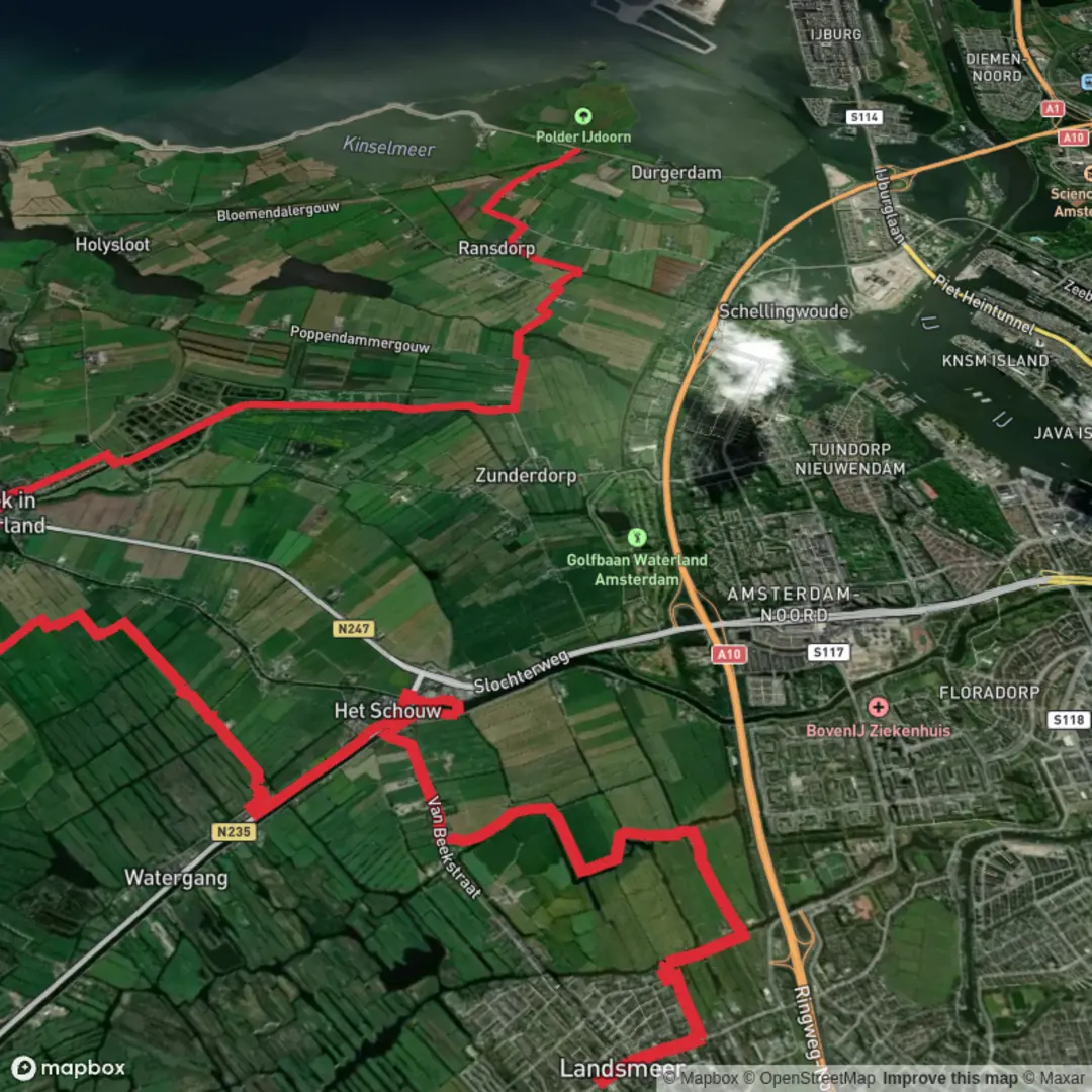
Raadhuisstraat to Uitdammerdijk via Vogermeerpolder and Broekervaart
Download
3D Flyover
Add to list
More
20.7 km
~4 hrs 7 min
0 m
Point-to-Point
“From Broek’s storybook lanes to Uitdammerdijk’s big-sky dikes, expect wind-swept, reflective miles.”
This is a flat, big-sky Waterland walk of about 21 km / 13.0 mi with essentially 0 m / 0 ft of climbing—more “distance day” than “hill day.” You’ll move from the historic village core of Broek in Waterland out into open polder, then finish on the exposed dike lines around Uitdammerdijk, where wind and weather are the main “elevation.”
Start location (nearest landmark/address): the most practical “Raadhuisstraat” start in this area is in/near the old village center of Broek in Waterland, close to the former town hall (Voormalig Raadhuis), Leeteinde 2, 1151 AK Broek in Waterland. (rijksmonumenten.nl)
Finish area (nearest landmark): Uitdammerdijk is the dike road running along the Markermeer side near Uitdam / Amsterdam-Noord (Waterland)—you’ll recognize it by the long, straight dike-top paths and wide water views.
Getting to the start (public transport + car)
- Public transport: From Amsterdam Centraal or Amsterdam Noord metro/bus hub, frequent buses run toward Broek in Waterland (commonly lines 314/316 toward Edam/Volendam). From the village bus stop, it’s a short walk into the old center to reach the Raadhuis/Leeteinde area. (broekerhuis.nl)
- By car: Aim for central parking in/near Broek in Waterland (signed village parking areas), then walk a few minutes into the historic core near Leeteinde.
Plan the line and keep yourself honest at junctions with HiiKER—this landscape is crisscrossed with dikes, farm tracks, and canals that can look deceptively similar.
You’ll typically be on a mix of village sidewalks/brick lanes, narrow paved dike roads, gravel farm tracks, and (depending on your exact variant) occasional softer grassy edges. After rain, the polder margins can be slick and muddy.
What you’ll see in the first third (0–7 km / 0–4.3 mi)
From the Raadhuisstraat/Leeteinde area you’re immediately in classic Broek in Waterland, a village known for its well-preserved historic character and long relationship with Amsterdam’s wealth—in the 17th–18th centuries it became a favored place for merchants and seafarers to live or keep homes, and much of that heritage remains visible in the streetscape. (en.wikipedia.org)
As you leave the tight village lanes, the route begins to “open up” into Waterland’s low peat meadow country. Expect: - Canals and drainage ditches everywhere—these are not decorative; they’re the working plumbing of the polder landscape. - Long sightlines across pasture and reedbeds, with very little vertical relief. - Wind exposure increasing steadily as buildings thin out.
Middle section: Vogermeerpolder/Volgermeer area + Broekervaart (about 7–15 km / 4.3–9.3 mi)
This portion is the heart of the walk: water, reeds, and birdlife, with the route often tracking canal lines.
Broekervaart: the “spine” of the landscape
The Broekervaart is a historic canal/vaart that runs through this region, linking waterways from the area around Broek in Waterland onward toward Edam, and it connects into the broader polder-water system. (ensie.nl)
Walking beside it feels like following a ruler-straight corridor through the fields—great for steady pacing, but it can be mentally long if the wind is in your face.
Volgermeer / “Vogermeerpolder” (often referenced as Volgermeerpolder)
If your route line passes through/near **Volger

Surfaces
Asphalt
Unknown
Grass
Paved
Gravel
Cobblestone
Wood
Comments and Reviews
User comments, reviews and discussions about the Raadhuisstraat to Uitdammerdijk via Vogermeerpolder and Broekervaart, Netherlands.
average rating out of 5
0 rating(s)