Download
3D Flyover
Add to list
More
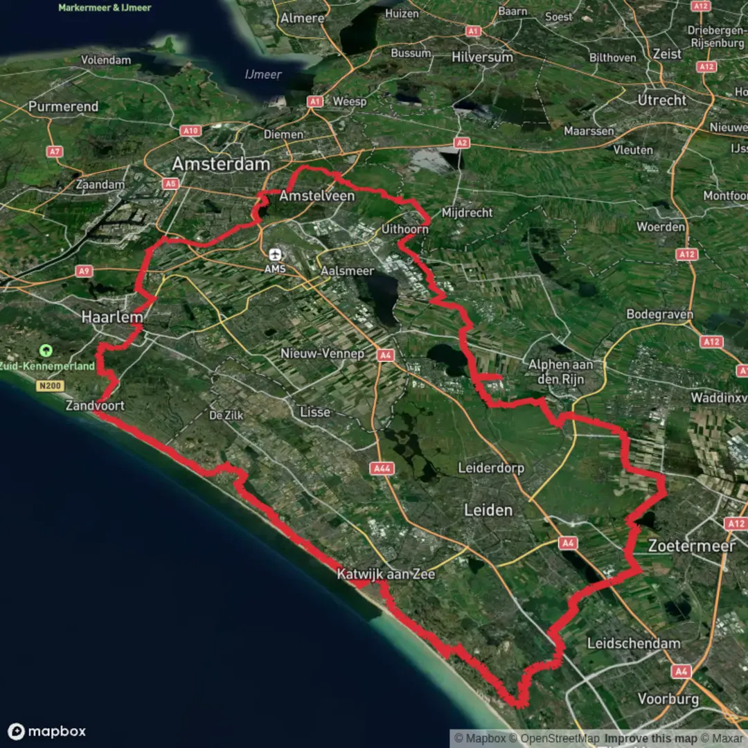
155.1 km
~6 days
6 m
Multi-Day
“A sprawling flat loop through dunes, canals and polders—wind, distance and mixed surfaces shape the day.”
This is a long, low-lying loop of roughly 155 km (96 mi) with essentially 0 m (0 ft) of climbing, linking a network of Dutch-style multi-use paths through dune edges, polders, canals, and small settlements. Expect a “big day out” (or more realistically a multi-day outing) where the challenge is distance, wind exposure, and surface variety, not elevation.
Because your start point is listed only as “near” (with no coordinates), I can’t reliably convert the lon/lat to a nearest address or landmark yet. If you share the start coordinates (or a GPX / HiiKER link), I’ll pin it to the closest known address or prominent landmark and tailor the transport directions precisely.
What the route feels like underfoot (and why it stays “easy”)
- Terrain & surfaces: Predominantly paved cycle paths, compacted gravel, and canal-top tracks. This is why the elevation gain stays near zero. You’ll likely encounter occasional brick pavers, short sandy patches near dune margins, and farm access lanes.
- Effort profile: “Easy” in terms of gradient and technicality, but 155 km (96 mi) is a serious endurance distance. Many hikers split it into 2–4 days:
- 2 days: ~77.5 km (48 mi) per day (very demanding)
- 3 days: ~52 km (32 mi) per day (still big)
- 4 days: ~39 km (24 mi) per day (more comfortable)
- Wind: With open polders and exposed dune edges, headwinds can be the main difficulty. Plan conservative pacing if the forecast is breezy.
Navigation and wayfinding (keep it simple)
This kind of path network can be deceptively “busy” with frequent junctions. Use HiiKER for: - Staying on the correct parallel path when multiple tracks run alongside canals/roads - Confirming you’re on the pedestrian-legal alignment where cycleways and footpaths diverge - Spotting resupply points and transit options if you need to shorten the day
Dunes, polders, and waterways: what you’ll see
Even without big climbs, the landscape changes subtly as you move between dune fringe and reclaimed lowlands.
Dune-edge sections (Zuidduinen feel)
Where the route brushes the southern dune belt, you’ll notice: - Sandy soils, scrubby vegetation, and wind-shaped grasses - Occasional dune woodland pockets (often planted) that provide brief shelter - A brighter, more open horizon and a “coastal plain” feel even when you’re not right on the beach
Wildlife to watch for in these dune-adjacent stretches: - Rabbits and hares, often at dawn/dusk - Raptors (kestrels and buzzards are common in open country) - In wetter dune slacks, seasonal waterfowl and amphibians
Canal and polder corridors (Oostvaartpad character)
Along canal paths and drainage corridors: - Expect long, straight segments with water on one side and fields on the other - Frequent bridges, locks, pumping stations, and sluice structures—small but distinctive landmarks that help confirm position - Birdlife is often the highlight: geese, ducks, coots, herons, and in migration seasons, large mixed flocks feeding in fields
Historical significance you’ll feel along the way
This landscape is shaped by centuries of Dutch water management: - Polders are reclaimed or drained lands kept habitable by a managed system of dikes, canals, and pumping. The “flatness” of your elevation profile is a direct result of this engineered environment. - The presence of vaart (canals) and pad (paths) reflects how transport and maintenance routes developed alongside waterways—first for commerce and drainage, later formalized into today’s path networks. - Dune belts historically served as natural coastal defenses, while inland drainage systems protected farmland and settlements from flooding.
Practical planning: time, food, water, and facilities
- Time on feet: At a steady hiking pace of 4–5 km/h (2.5–3.1 mph) plus breaks, the full loop is typically 30–40 hours of moving time—another reason most people stage it.
- Resupply: You’ll likely pass through towns or village edges regularly, but opening hours can be limited in smaller places. Carry enough food for half a day at minimum, more if you’re walking early/late.
- Water: In the Netherlands, potable water access varies by area. Don’t assume canal-side taps. Plan to refill in towns, cafés, supermarkets, or accommodations.
- Toilets: Most reliable in towns, transit hubs, and larger parks; less so on rural canal paths.
Hazards and things to look out for
- Shared-use traffic: Many segments will be popular with cyclists. Stay predictable, keep right, and be extra cautious at blind corners and bridge approaches.
- Road crossings: Even if most of the route is off-road, you’ll cross regional roads. Treat every crossing as high attention—fast bikes and cars can appear quickly.
- Weather exposure: With minimal tree cover in polders, sun and wind are constant factors. Bring:
- Windproof layer (even in mild temperatures)
- Sun protection (hat, sunglasses, sunscreen)
- A light rain shell—showers can sweep through quickly
- Foot care: Long paved stretches can be harder on feet than trails. Consider cushioned footwear

Surfaces
Asphalt
Unknown
Paved
Concrete
Grass
Wood
Comments and Reviews
User comments, reviews and discussions about the Rijwielpad Zuidduinen, Ganzenhoekweg and Oostvaartpad Loop, Netherlands.
average rating out of 5
0 rating(s)