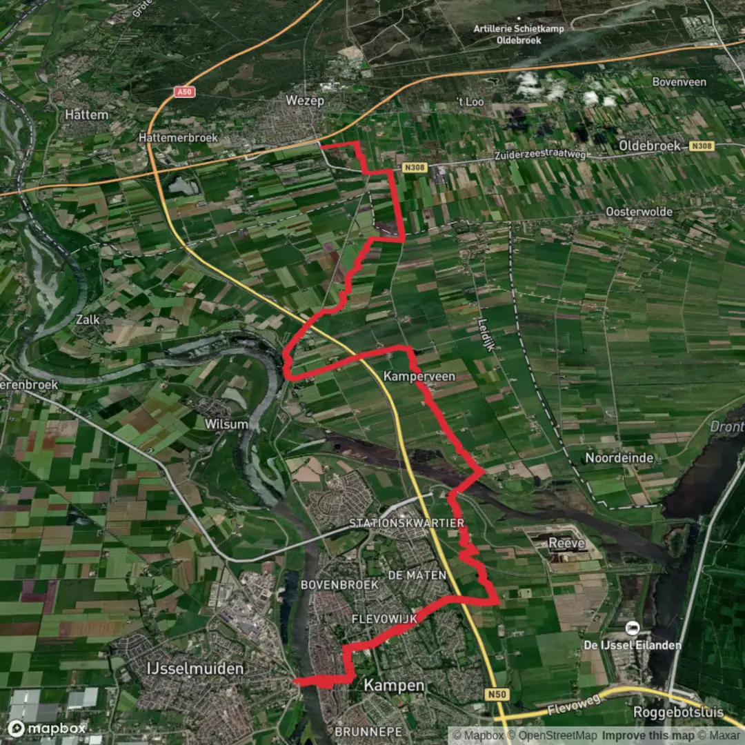
Kampen to Ijsselvlliedt via Reevediep, Pol Weg and Zuiderzeestraat Weg
Download
3D Flyover
Add to list
More
20.8 km
~4 hrs 10 min
8 m
Point-to-Point
“Stroll from Kampen’s medieval heart to wide-open polders, where wildlife, waterways, and history shine.”
Starting from the historic city of Kampen, this 21 km (about 13 miles) route offers a flat, easy walk with virtually no elevation gain, making it accessible for most hikers. The trailhead is conveniently located near Kampen’s central railway station, allowing for easy access by train from major Dutch cities like Zwolle and Amsterdam. For those arriving by car, parking is available near the station and in the city center.
Leaving Kampen and Entering the Dutch Countryside
The hike begins by weaving through Kampen’s charming old town, known for its medieval gates and the impressive Bovenkerk. After leaving the city, the route quickly transitions to the open landscapes typical of the IJsseldelta. The first stretch follows the banks of the IJssel River, where you’ll see expansive views across the water and the flat, fertile fields that characterize this region. Birdlife is abundant here, especially in spring and autumn, with opportunities to spot herons, storks, and migratory waterfowl.
Reevediep and the New Dutch Waterways
At around 5 km (3 miles), the path joins the Reevediep, a recently constructed water channel designed to manage river flooding and restore natural habitats. This area is a showcase of Dutch water engineering and environmental restoration. The wide, grassy embankments are home to wildflowers and grazing cattle, and the open skies make it a favorite spot for birdwatchers. The Reevediep bridge offers panoramic views and is a good place to pause for photos.
Pol Weg and Zuiderzeestraat Weg: Through Polders and History
Continuing along Pol Weg, the trail passes through classic Dutch polder landscapes—flat, reclaimed land protected by dikes. These areas are dotted with traditional farmhouses and windmills, reflecting centuries of Dutch land management. At about 12 km (7.5 miles), you’ll cross the Zuiderzeestraat Weg, a historic route that once connected inland towns to the former Zuiderzee (now the IJsselmeer). This section is particularly rich in history, as the region played a key role in the Netherlands’ battle against the sea, with many dikes and sluices dating back to the 19th century.
Wildlife and Natural Highlights
The flat terrain and open water attract a variety of wildlife. Look for hares and roe deer in the fields, and keep an eye out for marsh harriers and kestrels hunting above the reeds. In summer, the meadows are alive with butterflies and dragonflies. The route is exposed, so sun protection is recommended, and there are few shaded areas.
Navigation and Facilities
Navigation is straightforward, with well-marked paths and signage at key junctions. For detailed route planning and real-time navigation, use HiiKER, which provides up-to-date trail maps and points of interest. Facilities along the route are limited, so bring sufficient water and snacks. Public toilets and cafes can be found in Kampen at the start and near the endpoint at IJsselvliedt, a historic estate known for its landscaped park and stately manor.
Getting There and Away
Kampen is easily reached by train, with frequent services from Zwolle and Lelystad. Buses also connect Kampen with surrounding towns. If driving, use the parking facilities near Kampen station or in the city center. The endpoint at IJsselvliedt is near the village of Wezep, where local buses can return you to Kampen or connect to regional train services.
This route offers a unique blend of Dutch history, water management, and open countryside, making it an ideal day hike for those seeking a gentle but rewarding walk through one of the Netherlands’ most iconic landscapes.

Surfaces
Asphalt
Unknown
Concrete
Ground
Comments and Reviews
User comments, reviews and discussions about the Kampen to Ijsselvlliedt via Reevediep, Pol Weg and Zuiderzeestraat Weg, Netherlands.
average rating out of 5
0 rating(s)