Download
3D Flyover
Add to list
More
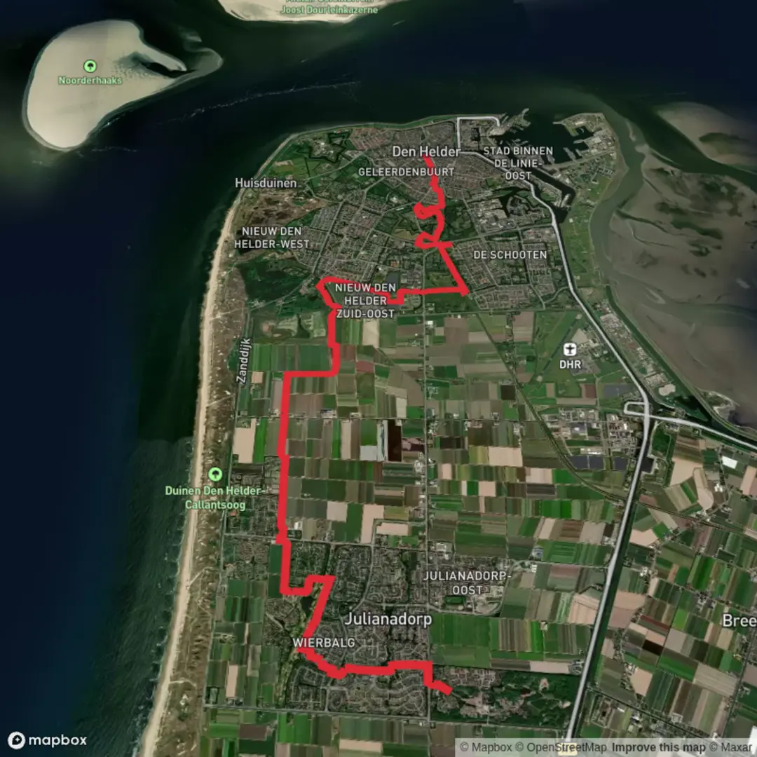
16.2 km
~3 hrs 14 min
0 m
Point-to-Point
“From Noorderhaven to Den Helder, drift through wind-sculpted dunes and surprise art, weather permitting.”
This is a mostly flat, coastal North Holland walk that links the old harbor area at Noorderhaven with Den Helder, threading through dune reserves and two standout landscape-art areas (Mariëndal and De Nollen). At roughly 16 km / 10 miles with about 0 m / 0 ft of climbing, it’s well-suited to a relaxed pace—but it’s still an exposed route where wind, sand, and sudden showers can shape the day.
Getting to the start (Noorderhaven area)
By public transport - The simplest approach is to travel by train to Alkmaar and connect onward by regional bus toward the Noorderhaven / harbor area (services vary by day and season). From the nearest bus stop, expect a short walk to the water. - If you’re already in the region, local buses also connect surrounding towns to the harbor district.
By car - Navigate to the Noorderhaven harbor area (near the waterfront quays and marina) and use public parking around the harbor streets. In busy periods, parking can fill quickly near the water; having a backup lot a few blocks inland helps.
If you share the exact coordinates (lon/lat) for “Hike head: near …”, I can pin it to the nearest named quay/street or a specific harbor landmark and describe the first 500–800 m precisely.
What to expect underfoot and on the horizon
You’ll be on a mix of paved harbor paths, compacted gravel, dune tracks, and sandy footpaths. Because the elevation change is negligible, the “effort” comes more from: - Soft sand patches in the dunes (slower going, more calf/ankle work) - Headwinds along open stretches (especially near the coast) - Short, steep micro-undulations in dune terrain (not real elevation gain, but noticeable)
Plan on 3.5–5 hours depending on stops, wind, and how much time you spend exploring viewpoints and art installations.
Noorderhaven to the dune edge (about 0–4 km / 0–2.5 miles)
The opening kilometers feel maritime and spacious: quays, small craft, and working-waterfront details give way to greener edges as you leave the harbor behind. This is a good place to do an early gear check because once you commit into the dunes, wind exposure increases and sand can get into shoes.
Landmarks and atmosphere - Harbor basins and marina infrastructure (good visual handrails for navigation) - Long sightlines: you’ll often see dune ridges ahead, which become your next “target” as the built environment thins out
Look out for - Cyclists and service vehicles on shared paths near the harbor - Slippery surfaces after rain on smooth paving near the water
Mariëndal: dune reserve walking (about 4–10 km / 2.5–6.2 miles)
Mariëndal is where the walk turns distinctly “North Sea dunes”: low, wind-shaped ridges, scrubby vegetation, and pockets of shelter that can feel surprisingly quiet even on breezy days. The terrain stays essentially flat overall, but the path may weave and roll gently.
Nature and wildlife - Expect classic dune plants: marram grass stabilizing sand, low shrubs, and seasonal wildflowers in more sheltered hollows. - Wildlife is often subtle rather than dramatic: songbirds, occasional raptors riding the wind, and small mammals that keep to cover. In quieter moments you may spot rabbits or signs of them along sandy margins. - In wetter periods, dune slacks can hold water—watch for muddy edges and slick boardwalks if present.
Practical notes - Footwear: trail shoes are fine, but choose something that handles sand well; gaiters can help if you dislike sand in socks. - Wind management: bring a windproof layer even on mild days; the perceived temperature can drop quickly in open dune corridors. - Navigation: dunes can be disorienting because everything looks similar. Keep your route loaded in HiiKER and use it to confirm junctions—especially where multiple sandy tracks braid together.
De Nollen: landscape art and coastal character (about 10–13.5 km / 6.2–8.4 miles)
De Nollen is a highlight because it blends dune scenery with large-scale outdoor artworks and sculptural elements. The feel becomes more curated and surprising—expect moments where the path bends toward installations, viewpoints, or sheltered clearings.
What to look for - Artworks integrated into the dune landscape (often best appreciated by slowing down and scanning the slopes and clearings) - Strong contrasts: raw sand and wind-sheared vegetation set against bold forms and textures
Look out for - Narrow sandy paths where passing can be awkward—step off carefully to avoid trampling fragile dune vegetation. - If it’s wet and windy, some exposed viewpoints can feel harsher than expected; keep a warm layer accessible.
Final approach into Den Helder (about 13.5–16 km / 8.4–10 miles)
The last stretch transitions back toward urban edges and the Den Helder area. You’ll likely notice more paved surfaces, clearer wayfinding, and more people as you near town.
Services and logistics - Den Helder is a practical endpoint: you’ll have access to shops, cafés, and public transport for the return. - If you’re timing a connection, build in buffer time—dune walking speed can vary a lot with wind and

Surfaces
Unknown
Asphalt
Paved
Unpaved
Grass
Comments and Reviews
User comments, reviews and discussions about the Noorderhaven to Den Helder via Mariendal and De Nollen, Netherlands.
average rating out of 5
0 rating(s)