Download
3D Flyover
Add to list
More
19.0 km
~3 hrs 47 min
0 m
Point-to-Point
“Trace shimmering dikes and wildflower meadows from Kampen to Genemuiden, savoring Dutch history and skies.”
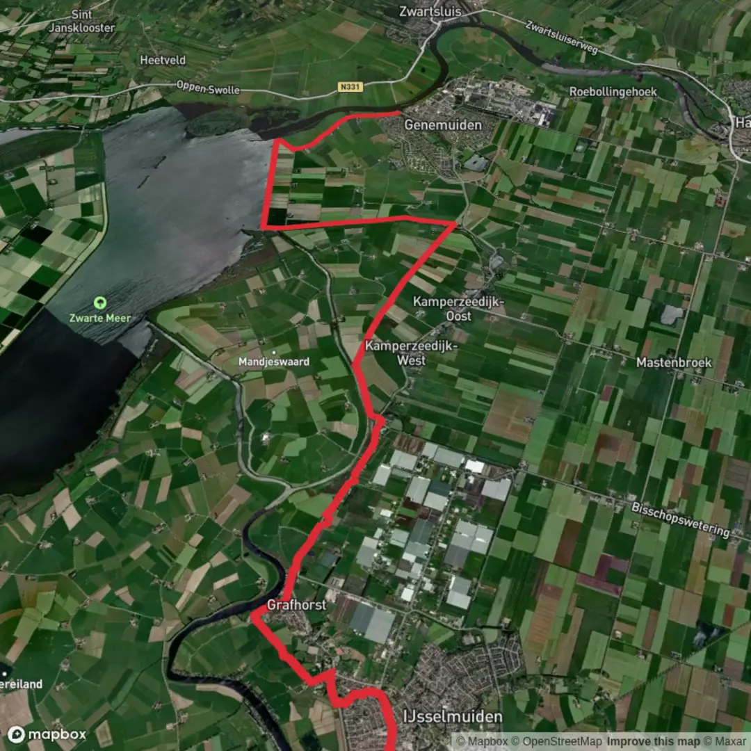
Starting near the Stadsbrug in IJsselmuiden, this 19 km (about 11.8 miles) point-to-point walk follows the Zuiderzeepad and Ketting Weg, tracing the edge of the former Zuiderzee and ending in the charming town of Genemuiden. With virtually no elevation gain, this route is ideal for those seeking a relaxed, scenic journey through the Dutch lowlands.
Getting There
The hike begins at the Stadsbrug, a prominent bridge connecting Kampen and IJsselmuiden. For those arriving by public transport, Kampen railway station is the nearest major stop, just a short walk from the bridge. Buses also serve IJsselmuiden from surrounding towns. If driving, parking is available near the bridge and in Kampen’s city center.
Route Overview and Navigation
The trail follows the Zuiderzeepad, a long-distance path marked by red and white blazes, and the Ketting Weg, both of which are well-maintained and easy to follow. For precise navigation, HiiKER provides up-to-date maps and waypoints, ensuring you stay on track throughout the journey.
Landmarks and Points of Interest
- Stadsbrug and Kampen’s Historic Skyline (0 km / 0 miles): The hike starts with views of Kampen’s medieval towers and the IJssel River. Kampen is renowned for its Hanseatic history, visible in its well-preserved city gates and merchant houses.
- IJsseldelta Wetlands (2–6 km / 1.2–3.7 miles): As you leave the urban area, the path skirts the IJsseldelta, a mosaic of wetlands, reed beds, and grazing meadows. This area is a haven for birdlife, including spoonbills, herons, and migratory geese.
- Zuiderzeepad Dikes and Polders (6–14 km / 3.7–8.7 miles): Walking atop ancient dikes, you’ll see the flat, reclaimed polders that characterize the Dutch landscape. These engineering marvels protected the hinterland from the once-turbulent Zuiderzee, now tamed as the IJsselmeer after the construction of the Afsluitdijk in 1932.
- Kettingbrug and Ferry Crossing (approx. 15 km / 9.3 miles): Near Kettingbrug, you may encounter a small ferry or bridge crossing, depending on the season and water levels. This spot offers panoramic views over the water and is a good place to rest.
- Genemuiden’s Historic Center (19 km / 11.8 miles): The route ends in Genemuiden, a town famous for its centuries-old matting and carpet industry. The old harbor and cobbled streets invite exploration, and local cafés offer a chance to relax after your walk.
Nature and Wildlife
Throughout the hike, expect to see grazing sheep and cattle, wildflowers in spring and summer, and a variety of waterfowl. The flat terrain and open skies make this a favorite route for birdwatchers and photographers.
Practical Tips
- The entire route is flat, with an elevation gain of less than 5 feet (0 meters), making it accessible for most walkers.
- Surfaces are a mix of paved paths, gravel, and grassy dikes; waterproof footwear is recommended, especially after rain.
- Facilities are limited between Kampen and Genemuiden, so carry water and snacks.
- Public transport options are available in both Kampen and Genemuiden for your return journey.
This hike offers a gentle immersion into the Dutch polder landscape, rich in history and natural beauty, with easy logistics and plenty of opportunities to enjoy the tranquility of the countryside.

Surfaces
Asphalt
Unknown
Grass
Concrete
Comments and Reviews
User comments, reviews and discussions about the Stadsbrug to Genemuiden via zuiderzeepad and Ketting Weg, Netherlands.
average rating out of 5
0 rating(s)