Download
3D Flyover
Add to list
More
9.2 km
~1 hrs 53 min
28 m
Loop
“Wander tranquil lakesides, dark dunes, and blooming heath in a vibrant tapestry of North Brabant’s landscapes.”
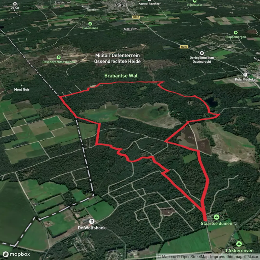
The Zwaluwmeer, Zwarte Duin, and Staartse Heide Loop is a scenic 9-kilometer (approximately 5.6 miles) trail with minimal elevation gain, making it accessible for hikers of all skill levels. The trailhead is located near the town of Ossendrecht in the North Brabant province of the Netherlands.
Getting to the Trailhead
For those traveling by car, Ossendrecht is accessible via the A4 motorway. Parking is available near the town center, close to the starting point of the hike. If using public transport, take a train to Bergen op Zoom station. From there, bus services run to Ossendrecht, with stops near the trailhead.
Trail Overview
The loop begins in the vicinity of Zwaluwmeer, a serene lake known for its clear waters and surrounding greenery. The path meanders through diverse landscapes, including dense woodlands, open heathlands, and sandy dunes. The terrain is predominantly flat, ensuring a comfortable walking experience.
Zwaluwmeer
Starting near Zwaluwmeer, hikers are greeted by the tranquil ambiance of the lake. The area is a haven for birdwatchers, with various waterfowl species frequenting the lake. The surrounding vegetation includes a mix of deciduous and coniferous trees, providing ample shade during the warmer months.
Zwarte Duin
As the trail progresses, it leads into the Zwarte Duin (Black Dune) area. This section is characterized by its unique black sand dunes, a result of historical peat extraction. The contrasting dark sands against the vibrant green vegetation create a striking landscape. Hikers should be prepared for slightly looser footing in this sandy terrain.
Staartse Heide
The final segment of the loop traverses the Staartse Heide, an expansive heathland known for its blooming heather during late summer. The open landscape offers panoramic views and is home to a variety of wildlife, including deer and numerous bird species. The heathland's sandy soils support a range of unique plant species adapted to the nutrient-poor conditions.
Historical Significance
The region holds historical importance due to its strategic location near the Belgian border. During various periods, including World War II, the area was utilized for military operations and training exercises. Remnants of old bunkers and fortifications can still be found, serving as silent witnesses to the area's past.
Navigation and Safety
The trail is well-marked, but it's advisable to use a reliable navigation tool like HiiKER to ensure you stay on course. The path is predominantly flat, but certain sections, especially in the Zwarte Duin area, may have loose sand. Wearing sturdy footwear is recommended. Additionally, while the trail is accessible year-round, the heathland is particularly picturesque during the late summer months when the heather is in full bloom.
Amenities and Facilities
Facilities along the trail are limited. It's advisable to carry sufficient water and snacks. The town of Ossendrecht offers various amenities, including cafes and restrooms, which can be utilized before or after the hike.
Embarking on the Zwaluwmeer, Zwarte Duin, and Staartse Heide Loop provides hikers with a diverse experience, showcasing the natural beauty and historical depth of the North Brabant region.

Surfaces
Unknown
Unpaved
Dirt
Sand
Comments and Reviews
User comments, reviews and discussions about the Zwaluwmeer, Zwarte Duin and Staartse Heide Loop, Netherlands.
average rating out of 5
0 rating(s)