Download
3D Flyover
Add to list
More
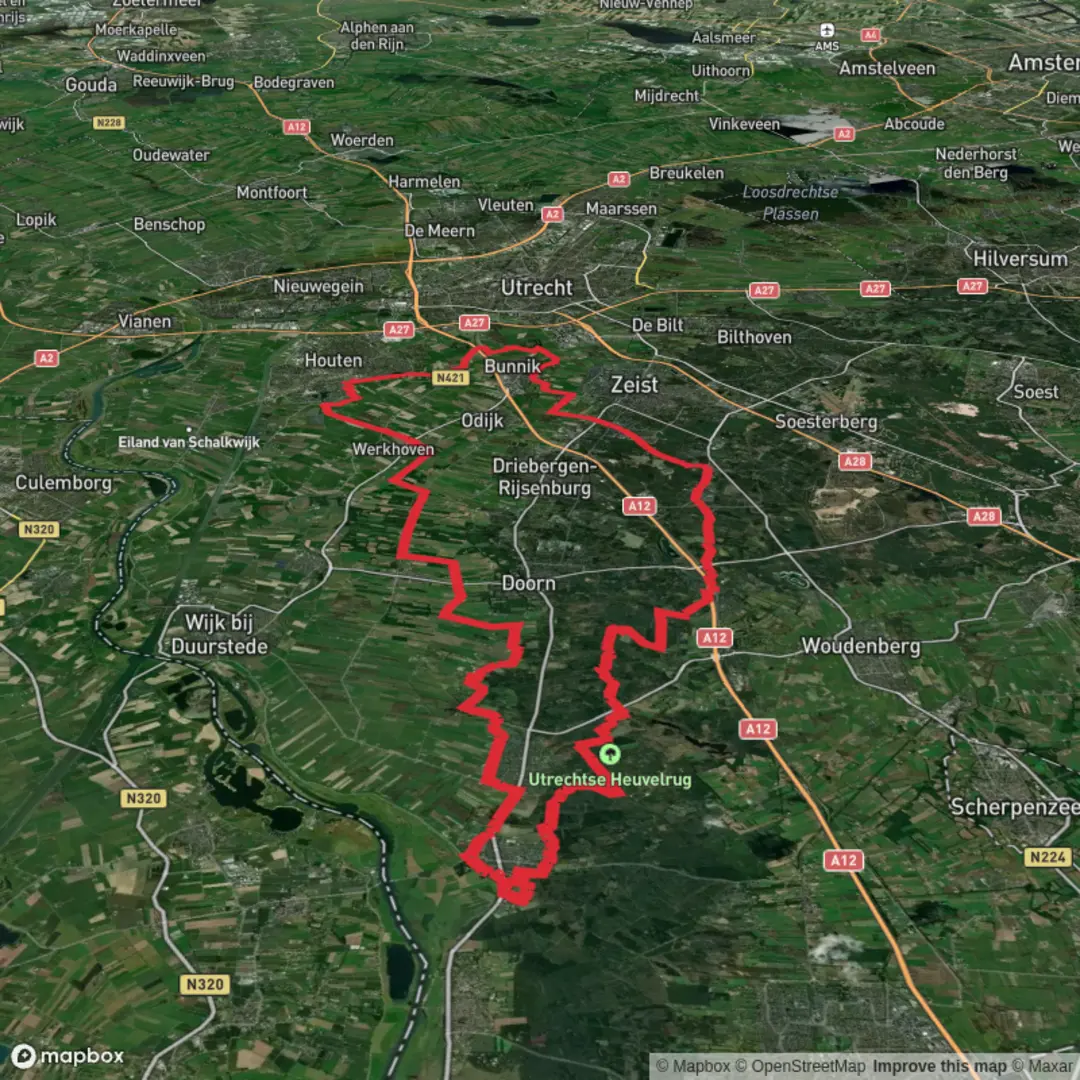
67.3 km
~3 days
141 m
Multi-Day
“A gentle Heuvelrug loop of sandy forest lanes and quiet villages—beautifully long, subtly demanding, and easy to misread at junctions.”
This is a long, low-relief loop of roughly 67 km (41.6 mi) with about 100 m (330 ft) of total climbing—an all-day walk (or a relaxed two-day) that strings together quiet village edges, long straight “lanes” through estate woodland, and broad, sandy forest tracks typical of the Utrechtse Heuvelrug. Underfoot you’ll mostly have firm surfaces: compacted sand/gravel forest paths, short paved connectors along Rijksstraatweg-type roads, and occasional brick or asphalt cycleway sections. Because the elevation gain is modest, the main challenges are distance, repetition of long forest corridors, and staying oriented at multi-track junctions—use HiiKER to keep the correct line when paths braid and rejoin.
Getting to the start (public transport + car)
Most versions of this loop sit naturally on the south side of the Utrechtse Heuvelrug between Driebergen-Zeist / Doorn / Leersum / Amerongen / Rhenen. A practical “start area” to plan around is Leersum on the N225 (Rijksstraatweg)—a well-known corridor through the ridge landscape. From there you can shape the loop to match the 67 km target.
- By train + bus: Take the train to Driebergen-Zeist Station (major rail hub for the ridge area), then connect by regional bus toward Doorn / Leersum / Amerongen / Rhenen depending on your exact start. The area is well served by buses that link the ridge villages and rail stations. (ns.nl)
- By car: Aim for parking along Rijksstraatweg (N225) near Leersum/Elst where there are established pull-ins/parking areas used for Heuvelrug walks. If you want a very specific, commonly referenced parking anchor, the Rijksstraatweg (N225) area near Elst (Utrecht) is frequently used as a start/park point for ridge walks. (naturescanner.nl)
Route character and what you’ll see (broken into manageable chunks)
Because this is a long loop, it helps to think in quarters. Distances below are approximate and will vary slightly depending on the exact junction choices you follow on HiiKER.
0–17 km (0–10.6 mi): Rijksstraatweg edges into ridge woodland
You’ll begin with a mix of village-edge walking and immediate immersion into the Heuvelrug’s push-moraine landscape—low hills, sandy soils, and long forest lines. Expect beech and oak mixed with conifer plantations, with wide, fast-draining tracks that stay walkable even after rain (mud is usually localized to low spots and horse-churned sections). The first hours are ideal for settling into a steady pace: the terrain is forgiving, but the day is long.
Landmarks here tend to be subtle: old straight lanes, estate boundaries, and occasional clearings that open briefly before the forest closes again. If your variant touches viewpoints on the ridge flank, you’ll get short, elevated looks over the lower agricultural land—more “big sky” than big mountains.
17–34 km (10.6–21.1 mi): Let de Stigterpad corridor—fast, straight, and easy to cruise
The Let de Stigterpad is best known as a long, continuous path through the Utrechtse Heuvelrug area, running broadly between Driebergen and Rhenen. (komoot.com)
Even though it’s often described in a cycling context, it’s extremely useful for hikers because it provides clean continuity through the forest with minimal elevation drama—perfect for covering distance efficiently.
You’ll notice a “designed” feel: long, direct segments, consistent surfacing, and frequent intersections with other forest tracks. This is where navigation errors most often happen—not because it’s confusing in a technical sense, but because many junctions look equally plausible. Keep HiiKER handy and confirm at each major crossing rather than trying to memorize “left-right-left” sequences.
Sub-headings: Nature, wildlife, and seasonal conditions
- Wildlife: In these ridge forests, the most likely sightings are roe deer, hares, and a steady soundtrack of woodland birds. Dawn and dusk increase your chances of deer at track edges.
- Ticks: From spring through autumn, ticks are a realistic concern in Dutch woodland and heath-edge grass—use rep

Surfaces
Asphalt
Unknown
Concrete
Sand
Grass
Unpaved
Comments and Reviews
User comments, reviews and discussions about the Rijksstraatweg, Let de Stigterpad and Koelaan Loop, Netherlands.
average rating out of 5
0 rating(s)