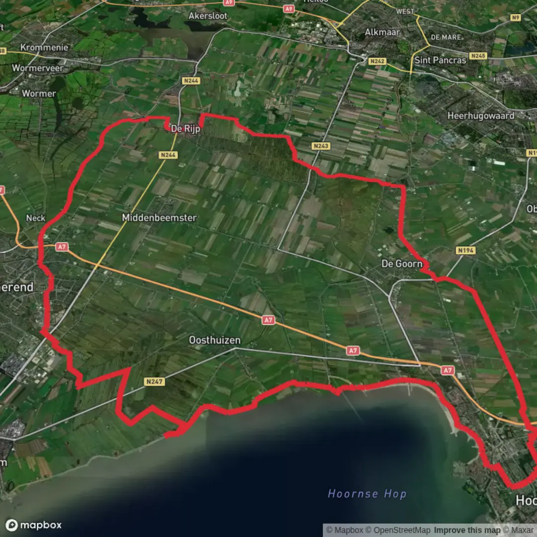
Hoornse Hop and Eilandspolder via Flevostraat, Eendentaantje and De Leet
Download
3D Flyover
Add to list
More
65.0 km
~3 days
0 m
Multi-Day
“A big-sky, wind-on-the-dike wander from Hoorn into reed-fringed polders—simple, but time-testing.”
This is a long, flat, big-sky walk through classic North Holland waterland: urban edges and parks in Hoorn, long dike-top straights with constant wind exposure, then hours of peat-meadow polder scenery where water, reeds, and grazing land dominate. At ~65 km (about 40 mi) with ~0 m / ~0 ft of climbing, the challenge is almost entirely time-on-feet, weather, and surface variety rather than elevation.
Because the route name references Flevostraat, Eendentaantje, and De Leet (all local place/street/waterway names), plan to load the full track in HiiKER before you arrive and download it for offline use—this landscape has lots of similar-looking paths, canals, and dikes where it’s easy to follow the “wrong” straight line for a long time.
Getting to the start (public transport + car)
Nearest major hub: Hoorn, North Holland (Noord-Holland), Netherlands. Hoorn has a main rail station (Hoorn) with frequent connections via the Dutch rail network, and local buses that reach residential districts and the city edge.
- By train: Travel to Hoorn station (NS). From there, use local bus or a short taxi/ride-share to the start area near the Flevostraat-side neighborhoods (the route name suggests you begin on/near a residential street segment before heading out toward the water and polder).
- By car: Drive toward Hoorn and park near the residential start streets (look for legal street parking or a small neighborhood lot). If you want a more “obvious” landmark to aim for in Hoorn before repositioning to the exact start, the historic harbor area and the Hoorn waterfront/Hoornse Hop side are easy reference points. Hoorn sits on the Markermeer and at the head of the bay called Hoornse Hop. (en.wikipedia.org)
If you share the route’s lon/lat startpoint(s), I can pin them to the nearest specific address/landmark precisely; with what’s provided, the most reliable “anchor” is Hoorn (city) near the Hoornse Hop/Markermeer edge.
What the terrain feels like over 65 km / 40 mi
Expect a steady rotation of: - Paved urban paths and residential streets (early/late stages near Hoorn) - Dike-top paths (often narrow, exposed, and windy) - Farm tracks and polder lanes (can be hard-packed, grassy, or muddy depending on season) - Canal-side walking with frequent bridges, sluices, and drainage channels
Even with “0 m” gain, dikes create constant micro-undulation (up-and-over ramps, bridge approaches), and the wind can make a flat route feel surprisingly taxing.
Hoornse Hop: water views and the city’s maritime backdrop
Early on, you’ll likely skirt green corridors and the city’s waterside edges before committing to longer rural lines. The Hoornse Hop is a bay/inlet of the Markermeer (historically tied to the former Zuiderzee), so you’ll get open-water horizons, waterfowl activity, and that distinctive Dutch “edge of land” feeling where the dike is the only obvious high ground. (omringdijk.nl)
Hoorn itself has deep historical weight: it received city rights in 1357 and flourished during the Dutch Golden Age as a major harbor town. That history shows up in the built environment if your route brushes the older center—harbor geometry, old quays, and the general “merchant city” layout. (en.wikipedia.org)
Eilandspolder and De Leet: peat-meadow wilderness in a working

Surfaces
Unknown
Asphalt
Grass
Concrete
Wood
Paved
Comments and Reviews
User comments, reviews and discussions about the Hoornse Hop and Eilandspolder via Flevostraat, Eendentaantje and De Leet, Netherlands.
average rating out of 5
0 rating(s)