Download
3D Flyover
Add to list
More
6.4 km
~1 hrs 17 min
15 m
Loop
“A gentle, flat loop where planet-posts and radio dishes thread quiet woods, solemn memorial ground, and a wet-heath boardwalk.”
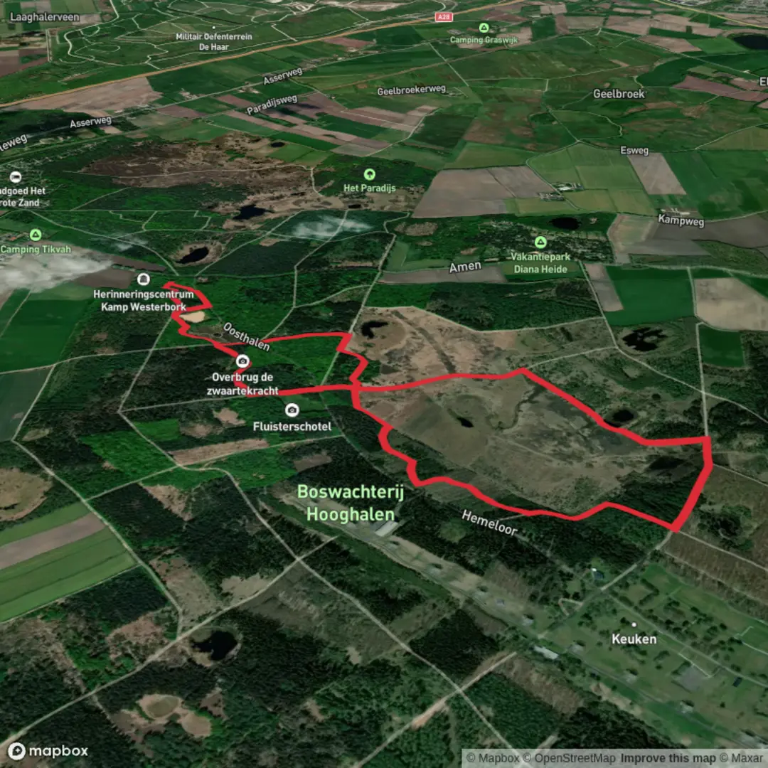
You’ll start and finish at Herinneringscentrum Kamp Westerbork (Oosthalen 8, 9414 TG Hooghalen, Drenthe)—the most practical, well-known trailhead for this loop and the easiest landmark to navigate to. From here, the route links the Hingsteveen (a wet heath/peat landscape) with the Melkwegpad (a solar-system themed path) and returns via forest tracks, staying essentially flat the whole way.
Expect around 6 km / 3.7 miles total with ~0 m / ~0 ft elevation gain. Underfoot is mostly firm and easy-going; parts are paved or hard-packed, with a short boardwalk (vlonder) section where the ground can be wet.
Getting to the start (car + public transport)
By car: Set your navigation to Herinneringscentrum Kamp Westerbork, Oosthalen 8, Hooghalen. There’s a dedicated visitor parking area at/near the museum complex, and it’s the standard access point for both the memorial site and the surrounding walking routes.
By public transport: The nearest rail hub is typically Station Beilen (regional trains). From there, local bus/taxi connections can get you toward the Herinneringscentrum Kamp Westerbork area; service patterns can vary by season and day, so check the current timetable before you go. Once at the Herinneringscentrum, the loop is straightforward to begin on foot.
If you’re using navigation, load the loop in HiiKER before you arrive so you can follow the correct turns where paths intersect in the forest.
From the visitor area, you’ll ease into quiet woodland on broad, accessible paths. Early on, the “Melkwegpad” character becomes obvious: you’ll pass planet-themed information points spaced to illustrate the scale of the solar system. It’s a gentle, family-friendly way to break up the first couple of kilometers (about 1–2 km / 0.6–1.2 mi) and it also helps with pacing—each marker becomes a natural “next checkpoint.”
As you continue, the landscape alternates between pine and mixed woodland with occasional openings. Birdsong is often the main soundtrack here; in calmer stretches you may notice woodpecker activity and small woodland birds moving through the canopy. Because the route is flat and sheltered, it can feel cooler and damper than nearby open heath—bring a light layer even on mild days.
The memorial landscape and the radio telescopes
Roughly around the mid-loop (about 2.5–3.5 km / 1.6–2.2 mi depending on exact line), you reach the area associated with Kamp Westerbork, a place of major historical significance: during World War II, it functioned as a transit camp from which many people were deported to Nazi concentration and extermination camps. The terrain here is quiet and deceptively ordinary, which can make the history feel even more stark—plan a little extra time if you want to pause at interpretive points rather than treating it as a pass-through.
Not far from the memorial area you’ll also encounter the striking presence of the Westerbork Synthesis Radio Telescope (WSRT)—a set of large parabolic antennas in the forest. The contrast is memorable: solemn history and cutting-edge astronomy infrastructure sharing the same broader landscape. The telescopes are a prominent landmark and a reliable “you’re in the right place” confirmation when checking your position in HiiKER.
Hingsteveen: wet heath, peat, and the boardwalk section
On the return side, the feel changes as you skirt the Hingsteveen—a wetter, more open mosaic of heath, peat soils, and small water features. This is where you’re most likely to meet soft ground and puddling, especially after rain. The route typically uses a vlonder/boardwalk to keep feet dry across the wettest patch; even so, the approaches can be muddy, so shoes with decent grip help.
Wildlife-wise, this is the best section for wetland/heath species: look for dragonflies in warmer months, and listen for the shift from woodland birds to more open-country calls. Keep an eye out for signs of larger mammals too—this region is managed with wildlife movement in mind, and you may notice how paths, verges, and underpasses are designed to reduce barriers.
After the Hingsteveen edge, you’ll re-enter forest and follow easy tracks back toward the Herinneringscentrum, closing the loop at about 6 km / 3.7 mi.
What to look out for: - Wet patches near the Hingsteveen: even with boardwalks, the margins can be slick. - Shared-use paths: some stretches are popular with cyclists; stay predictable on wider tracks. - Emotional weight near the memorial site: it’s worth planning time and headspace for a respectful visit rather than rushing through.

Surfaces
Unknown
Sand
Unpaved
Gravel
Asphalt
Wood
Grass
Comments and Reviews
User comments, reviews and discussions about the Hingsteveen and Melkwegpad Loop, Netherlands.
average rating out of 5
0 rating(s)