Download
3D Flyover
Add to list
More
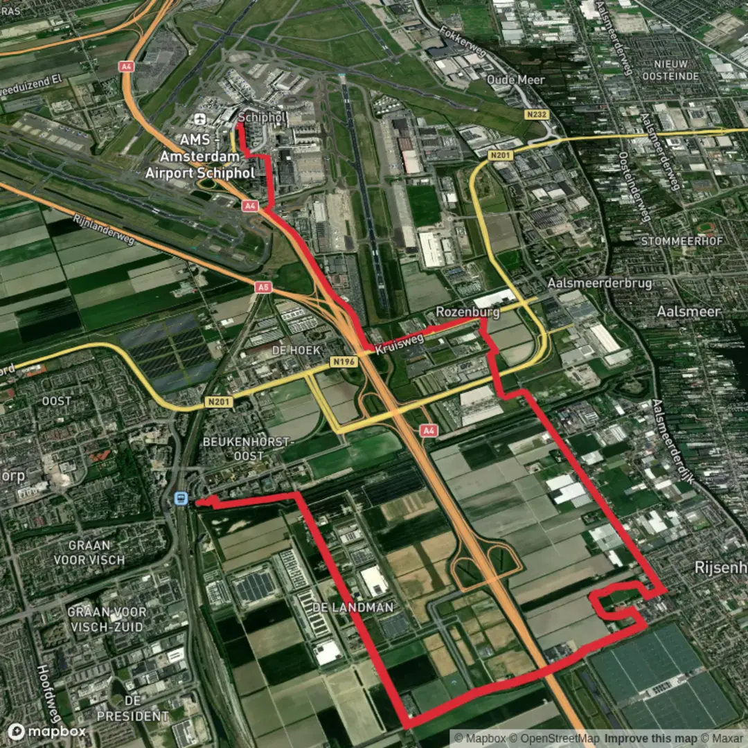
13.5 km
~2 hrs 41 min
0 m
Point-to-Point
“Stroll from Hoofddorp to Schiphol through wide-open fields, canals, and timeless Dutch polder charm.”
Starting from the heart of Hoofddorp, this 13 km (about 8 miles) point-to-point walk to Schiphol Airport follows the Rijnlanderweg and Bennebroekerweg, offering a flat, easy stroll through the Haarlemmermeer polder landscape. With virtually no elevation gain, this route is accessible for all levels and is especially suitable for those seeking a relaxed day hike or a scenic alternative to airport transit.
Getting There and Trailhead Access
The hike begins near Hoofddorp Station, a major transport hub easily reached by frequent trains from Amsterdam, Leiden, and The Hague. Buses also serve the station, and there is ample parking for those arriving by car. From the station, it’s a short walk to the start of Rijnlanderweg, where the journey begins.
Route Overview and Navigation
The route heads east along Rijnlanderweg, a broad, tree-lined road that quickly leaves the bustle of Hoofddorp behind. The landscape opens up to reveal the classic Dutch polder scenery: wide, flat fields, intersected by drainage ditches and canals, with distant views of wind turbines and the occasional farmhouse. Navigation is straightforward, but for added confidence, use HiiKER to track your progress and ensure you stay on course.
Landmarks and Points of Interest
About 2 km (1.2 miles) in, you’ll pass the historic Fort bij Hoofddorp, part of the UNESCO-listed Defense Line of Amsterdam. This 19th-century fortification is a reminder of the region’s strategic importance and the Dutch mastery of water management for defense. The fort is sometimes open for tours and events, so check ahead if you’re interested in a detour.
Continuing along Rijnlanderweg, the route parallels the Hoofdvaart canal, a central artery of the Haarlemmermeer polder. Watch for waterfowl such as coots, grebes, and herons, which are common in the area. The flat, open fields are also a good spot for spotting hares and, in spring and summer, a variety of wildflowers along the verges.
At around 7 km (4.3 miles), the route turns onto Bennebroekerweg, heading north toward Schiphol. This stretch is quieter, with fewer cars and more agricultural land. You’ll pass several traditional Dutch farms and may see grazing sheep or cows. The landscape here is shaped by centuries of land reclamation, with straight lines and geometric fields that tell the story of the Haarlemmermeer’s transformation from a vast lake to fertile farmland in the 19th century.
Approaching Schiphol and Finishing the Hike
The final kilometers bring you closer to Schiphol Airport, with the distant hum of planes growing louder. The route ends near Schiphol Plaza, the main terminal complex, which is well-signposted and accessible by footpaths. Here, you’ll find extensive public transport connections, including trains and buses to Amsterdam and other cities, as well as facilities for refreshments and rest.
Nature and Wildlife
Despite its proximity to urban centers and the airport, the route offers a surprising amount of birdlife and open space. The polder’s network of ditches and canals supports a variety of aquatic birds, and the fields are often alive with skylarks and lapwings. In winter, flocks of geese are a common sight.
Practical Tips
The entire route is paved and suitable for walking year-round, though wind can be a factor in this exposed landscape. There are few shaded areas, so sun protection is recommended in summer. Water and snacks should be brought along, as services are limited between Hoofddorp and Schiphol. Public toilets are available at both the start and end points.
For navigation and up-to-date trail information, HiiKER is recommended to ensure a smooth and enjoyable journey.

Surfaces
Unknown
Asphalt
Wood
Comments and Reviews
User comments, reviews and discussions about the Hoofddorp to Schiphol via Rijnlander Weg and Bennebroeker Weg, Netherlands.
average rating out of 5
0 rating(s)