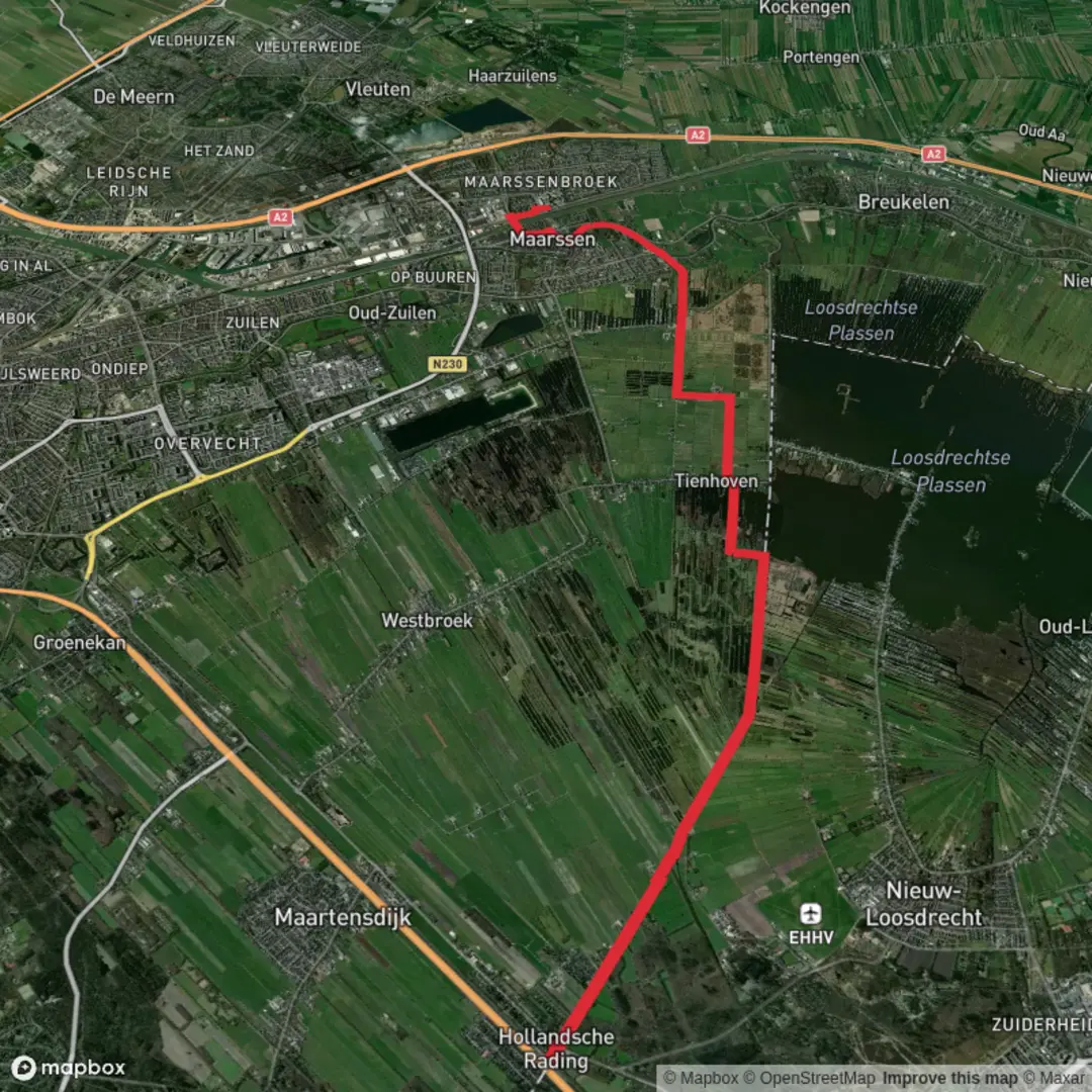
Hollandsche Rading to Maarssen via Tienhovensche and Maarsseveen
Download
Preview
Add to list
More
15.1 km
~3 hrs
0 m
Point-to-Point
“From forest fringe to reed‑laced polders, this flat waterside ramble trades shelter for big, breezy skies.”
This is a flat, water-rich point-to-point walk of about 15 km / 9.3 mi with roughly 0 m / 0 ft of elevation gain, linking the sandy-forest edge near Hollandsche Rading to the river-and-polder landscapes around Maarssen. Expect a mix of paved dikes and cycle paths, canal towpaths, and wide-open peatland views—easy underfoot, but often windy and exposed once you leave the trees.
Getting to the start (Hollandsche Rading)
- By train: Start at Station Hollandsche Rading, a small stop on the Hilversum–Utrecht line. The station sits right by the A27 motorway and is famously positioned on the border of Utrecht and North Holland provinces. (en.wikipedia.org)
- Nearest known address/landmark for the start: Station Hollandsche Rading, Vuurse Dreef 14, 3739 KT Hollandsche Rading (De Bilt). (treinstationinfo.nl)
- By car: Aim for the same address; parking is limited and local, so arriving by rail is usually simplest.
Getting back from the finish (Maarssen)
- By train: Finish at Station Maarssen (on the Amsterdam–Utrecht corridor). (en.wikipedia.org)
- Nearest known address/landmark for the finish: Station Maarssen, Safariweg (around no. 1), 3605 MA Maarssen. (tripomatic.com)
If you’re navigating the line of travel, load the route on HiiKER and keep an eye on where the path swaps between towpath, dike, and village edges—this area has many parallel cycle tracks that can look “right” at a glance.
What the walk feels like, section by section
0–3 km (0–1.9 mi): Forest edge and the “border” landscape
From the station area you quickly get the sense of being on a transition line: woodland and sandy soils give way to lower, wetter ground. The first couple of kilometers are typically the calmest underfoot—more shelter from wind, more tree cover, and a softer “edge-of-the-Gooi” feel before the route opens out.
Look out for:
- Fast cyclists on shared paths near settlements and station approaches.
- Muddy verges after rain where forest paths meet paved tracks.
3–10 km (1.9–6.2 mi): Tienhovensche Plassen and the peat-cutting country
As you approach the Tienhoven area, the landscape becomes classic Dutch lowland: long straight lines, water everywhere, and reedbeds that can feel almost endless. The Tienhovense Plassen are part of the broader Oostelijke Vechtplassen Natura 2000 complex, protected for birdlife. (eunis.eea.europa.eu)
This is where the walk’s “big nature” shows up: wide reed margins, open water, and marshy edges that are prime habitat for wetland birds. Depending on season, you may see or hear species associated with reed and marsh systems (the area is managed specifically to support moerasvogels—marsh birds). (varnws.nl)
Underfoot and exposure: mostly firm, often paved or hard-packed along dikes/towpaths—easy walking, but with little shade. In strong wind, this middle section can feel longer than the distance suggests.
Wildlife and nature to watch for
- Reedbed birds and waterfowl activity along the plassen and canals; bring binoculars if you like birding. The Natura 2000 designation highlights the importance of the area for bird species. (eunis.eea.europa.eu)
- Geese are common in these landscapes; management work in the area has included protecting reed

Surfaces
Unknown
Asphalt
Gravel
Concrete
Grass
Ground
Comments and Reviews
User comments, reviews and discussions about the Hollandsche Rading to Maarssen via Tienhovensche and Maarsseveen, Netherlands.
average rating out of 5
0 rating(s)