Download
3D Flyover
Add to list
More
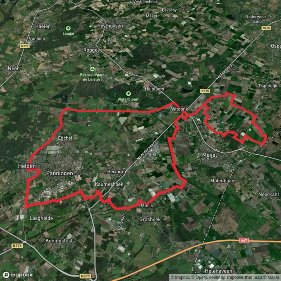
42.6 km
~2 days
0 m
Point-to-Point
“A long, flat Peel ramble through pine shade, sandy lanes and shimmering wetlands—best for confident navigators.”
This is a long, low-relief day out through the patchwork of woodland, heath, and wetland that characterizes the Peel region of Limburg (Netherlands). At roughly 43 km / 26.7 mi with about 0 m / 0 ft of climbing, the challenge is less about elevation and more about time on feet, surface variety (sand, forest track, farm lanes), and staying oriented through a dense network of junctions.
Getting to the start (car + public transport)
Because your start is only listed as “near …”, the most reliable way to pin it down is to treat Roggelseweg as the anchor and start near a clear, well-known access point along it. In this area, a practical “nearest significant landmark” to use as a meeting/start reference is:
- Roggelseweg, near the village of Roggel (Leudal, Limburg, NL) — use Roggel town center / church area as the last easy-to-find landmark, then navigate to the chosen trail access on Roggelseweg with HiiKER.
By car - Aim for Roggel (Leudal), then follow local signs toward Roggelseweg. Parking in this region is often a mix of small roadside pull-ins and designated forest car parks; choose a legal spot that doesn’t block farm access. If HiiKER shows a marked trailhead/parking icon on Roggelseweg, use that as your exact start.
By public transport - The most common approach is train to Roermond or Weert, then a regional bus toward Roggel/Heythuysen (routes vary by operator and season). From Roggel, you may have a short walk to reach Roggelseweg. Plan your return timing carefully—on a 43 km route, you don’t want to be racing the last bus.
What the route feels like underfoot
Expect a flat, fast-to-walk profile but with frequent transitions: - Forest tracks through Simonshoekse Bos: generally firm, sometimes needle-strewn and soft. - Sandy stretches: can be energy-sapping late in the day, especially if dry. - Wetland edges and low-lying paths near Kleine Moost: can be muddy or waterlogged after rain. - Farm lanes and quiet roads: easy walking, but watch for cyclists and local traffic.
Because the elevation gain is negligible, pacing is about steady efficiency. Many hikers treat this as a 7.5–10.5 hour outing depending on breaks and surface conditions.
Navigation and wayfinding (flat doesn’t mean simple)
This landscape is crisscrossed by forestry roads, bridleways, and field access tracks that can look nearly identical. The main pitfalls are: - Parallel tracks: you can be “almost right” for several kilometers before realizing you’re on the wrong line. - Junction clusters: multiple turns in quick succession where it’s easy to overshoot. - Seasonal overgrowth: in summer, some narrower connectors can be partially hidden.
Use HiiKER to: - Confirm you’re taking the correct branch at multi-track junctions. - Keep an eye on distance-to-next-turn so you don’t drift on a straight-looking track. - Identify water/settlement points for resupply (this route is long enough that planning stops matters).
Simonshoekse Bos: woodland character and what to look for
The “bos” sections are typically a mix of managed woodland and more natural edges. You’ll likely see: - Pine and mixed deciduous stands with open understory in places. - Straight forestry lines alternating with more meandering paths. - Birdlife: common woodland species (tits, woodpeckers, jays) and raptors overhead in open breaks. - Deer sign: tracks and browsing are common in Limburg woodlands; actual sightings are most likely early/late.
What to watch out for: - Ticks in grassy margins and heath/edge habitat—long socks and checks at breaks help. - After rain: puddled ruts on forestry roads can force detours onto softer verges.
Kleine Moost: wet ground, open skies, and peatland cues
“Moost/Moos” place-names in this region often hint at marshy or peaty ground. Even if the path is engineered, the surrounding terrain can stay wet. - Expect reeds, sedges, and damp hollows, with occasional boardwalk-like firming or raised track. - Frogs and dragonflies are common in warm months; in cooler seasons, look for waterfowl in open wet patches. - The walking can feel very different here: more exposure to wind, fewer landmarks, and more reflective water surfaces that make distances feel longer.
What to watch out for: - Soft shoulders: the center of a track may be firm while edges are boggy—step carefully when passing others. - Mosquitoes/gnats in still, humid conditions—especially near dusk.
Landmarks and “mental checkpoints” along a 43 km day
On a route this long and flat, it helps to break it into chunks. Without your exact GPX line, a practical planning structure is:
- 0–10 km (0–6.2 mi): Settling in—woodland entry, first junction density. Keep navigation tight early to avoid a costly correction.
- 10–22 km (6.2–13.7 mi): Long steady cruising—forest roads and field edges. This is a good window for your first longer

Surfaces
Unknown
Asphalt
Concrete
Gravel
Unpaved
Grass
Paved
Comments and Reviews
User comments, reviews and discussions about the Simonshoekse Bos and Kleine Moost via Roggelseweg, Netherlands.
average rating out of 5
0 rating(s)