Download
3D Flyover
Add to list
More
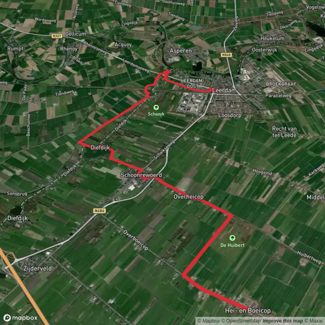
13.1 km
~2 hrs 37 min
0 m
Point-to-Point
“From Pleinstraat to Leerdam, drift through wind-swept dikes and dark wielen, where water remembers.”
Starting from Pleinstraat (the main street running through the village center), you’ll be walking through classic Dutch river-land scenery: flat, open horizons, long straight lanes, and a chain of “wielen” (deep, roundish flood-scour lakes) that were created when dikes failed and rushing water carved out basins. With essentially 0 m / 0 ft of climbing over ~13 km / ~8.1 mi, this is a steady, low-effort route where wind, wet ground, and narrow path edges are more likely to shape your day than elevation.
Getting to the start (Pleinstraat)
By public transport (Netherlands): - Aim for Leerdam as your rail hub (it’s the best-known town at the finish end of this route). From there, local buses typically connect to nearby villages; choose a stop that drops you near the village center where Pleinstraat is located. From the bus stop, you’re usually only a few minutes’ walk to the start. - If you’re planning point-to-point logistics, it’s often easiest to arrive by train at Leerdam, then bus/taxi to the Pleinstraat start, and finish back in Leerdam for the train home.
By car: - Navigate to Pleinstraat in the village center (use HiiKER to confirm the exact start pin and the closest legal parking). In these villages, parking is commonly on-street or in small public bays near shops/churches—watch for permit zones and “blue zone” time limits. - Because you finish in Leerdam, consider leaving the car near the finish and taking a short bus/taxi to the start, or arranging a second vehicle.
What the walk feels like (surface, exposure, and pacing)
Expect a mix of paved village streets, narrow dike-top lanes, and farm access tracks. Even when the route is “easy,” the walking can demand attention because: - Dike edges can be narrow with steep grassy slopes down to water. - Wind exposure is often constant in open polder landscapes; it can make an easy 13 km feel longer. - After rain, verges and field-edge paths can be soft and slick—especially where grass meets clay.
A comfortable pace for most hikers is 2.5–4 hours depending on stops, wind, and how often you pause at the wielen and fort features.
Along the wielen: Wiel Van Bassa and Het Wiel Fort
Not far into the route, the landscape begins to tell its story through water. The Wiel Van Bassa is part of a broader pattern you’ll see in this region: wielen formed by historic storm surges and dike breaches. They tend to be deeper than surrounding canals, often with darker water and a more abrupt shoreline. You’ll likely walk with water close by for stretches, so keep an eye on: - Slippery grass on the water side of the path - Unfenced edges (common here) - Anglers’ spots and narrow passing points
As you continue, Het Wiel Fort adds a human layer to the water-and-dike story. Fort sites in this part of the Netherlands are often tied to historic defensive water-management systems—where inundation (controlled flooding) and fortifications worked together to protect key routes and towns. Even if the fort is modest in scale, it’s a good place to slow down and look at how the land has been engineered: straightened channels, raised embankments, and the careful separation of “too much water” from “just enough water.”
Approximate distance markers (for planning): - 0–3 km (0–1.9 mi): Leaving Pleinstraat and transitioning from village streets to quieter lanes and field edges. - 3–7 km (1.9–4.3 mi): The most “watery” feeling section, with wielen features and frequent canal/dike proximity. - 7–10 km (4.3–6.2 mi): Fort area and surrounding dike infrastructure; good spot for a snack break out of the wind if you can find shelter. - 10–13 km (6.2–8.1 mi): Approaching Leerdam, you’ll gradually pick up more signs of town edges—more pavement, more cyclists, and clearer wayfinding.
Nature and wildlife to look for
This is a strong route for everyday lowland wildlife rather than big mammals. Depending on season and water levels, watch for: - Waterfowl (ducks, geese, coots) on the wielen and canals - Herons and egrets hunting along ditch margins - Raptors (kestrels and buzzards) hovering over fields - In warmer months, dragonflies and other insects concentrated near still water
You’ll also see classic polder vegetation: reed beds, rushes, and grassy dike slopes. In spring and early summer, field margins can be lively with wildflowers, but stay on the path—many edges are managed for drainage and can crumble underfoot.
Navigation and practical cautions (flat doesn’t mean foolproof)
Use HiiKER to keep track of the correct turns, especially where multiple farm tracks run parallel and where dike-top lanes intersect with small bridges.
Key things to plan for: - Wind chill: Even mild temperatures can feel cold on exposed dikes—bring a windproof layer. - Footwear: Light hiking shoes are usually enough, but choose something with grip for wet grass and muddy verges. - **

Surfaces
Asphalt
Unknown
Grass
Gravel
Paved
Concrete
Comments and Reviews
User comments, reviews and discussions about the Pleinstraat to Leerdam via Wiel Van Bassa and Het Wiel Fort, Netherlands.
average rating out of 5
0 rating(s)