Rijksweg, Graafseweg, Veerweg, Hoofdstraat and Tetefoonstraat Loop
Download
3D Flyover
Add to list
More
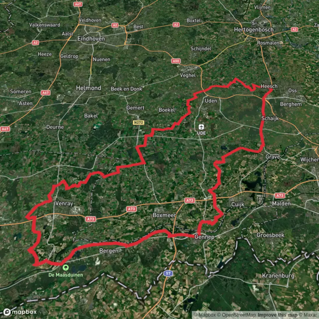
141.3 km
~5 days
0 m
Multi-Day
“A sprawling Dutch lowlands loop of dikes, canals, villages and wind—gentle terrain, big days.”
This is a long, low-lying loop of roughly 141 km (87.6 mi) with essentially 0 m (0 ft) of climbing—expect it to feel more like an endurance walk or multi-day ramble than a “hike” in the mountainous sense. The route name strings together several road/trail corridors (Rijksweg, Graafseweg, Veerweg, Hoofdstraat, Tetefoonstraat), which is a strong hint that you’ll be moving through settlements, farmland, canals/rivers, and dike-top paths typical of the Dutch lowlands. Underfoot is likely to be a mix of paved cycleways, brick sidewalks, compacted gravel farm tracks, and short grassy sections along water.
Because the start is listed only as “near,” the most practical way to pin it down is to use HiiKER to open the route and identify the exact trailhead point; once you have that point, you can match it to the nearest rail/bus stop, parking area, or prominent junction (often a church square, ferry landing on a “Veerweg,” or a main-road intersection on a “Hoofdstraat”). If you share the start coordinates (or a map screenshot), I can translate them into the nearest recognizable address/landmark precisely.
Getting to the start (car + public transport)
- By car: In this region, trailheads for long loops that follow named roads are commonly easiest from a town-center car park (look for “P” signage) or a park-and-ride near a larger station. Plan for paid parking in town centers and time restrictions in shopping streets (often around “Hoofdstraat” corridors).
- By public transport: The Netherlands’ rail-and-bus network makes it straightforward to start from a train station in the nearest larger town, then connect by local bus to a stop on/near Rijksweg / Graafseweg / Hoofdstraat. For a loop this long, many hikers choose to begin at a station so the start/finish logistics are simple if plans change.
- Practical tip for a 141 km loop: Even if it’s a loop, consider treating it like a 2–4 day itinerary and choose a start near lodging and food (supermarkets, bakeries, cafés). That reduces the amount of food you must carry and gives you bail-out options.
What the terrain feels like (and why “easy” can still be demanding)
With negligible elevation gain, the difficulty comes from distance, surface repetition, and exposure: - Surface: Long stretches of hard surface can fatigue feet, knees, and hips. Cushioned footwear and a blister strategy matter more than trekking poles here. - Exposure: Dikes and open fields can be windy with little shade. Sun and wind protection are key even on cool days. - Navigation: The route will likely weave through road names and local path networks; use HiiKER to stay on the intended line, especially where cycleways, farm access roads, and footpaths braid together.
Route character and pacing (approximate breakdown)
At 141 km (87.6 mi), a common planning approach is: - 3 days: ~47 km/day (29 mi/day) — long days, early starts, minimal sightseeing time. - 4 days: ~35 km/day (21.8 mi/day) — more comfortable, better for café stops and detours. - 2 days: ~70 km/day (43.5 mi/day) — only for very conditioned walkers; recovery becomes the main challenge.
Even if the elevation gain is near 0 m, expect small “micro-undulations” from bridges, dike ramps, underpasses, and locks—not enough to register as climbing, but enough to change stride rhythm.
Landmarks, scenery, and the “Veerweg” clue
A “Veerweg” is often associated with a ferry road leading to a river crossing. That usually means at least one of the following: - A ferry landing (sometimes seasonal or with limited hours) - A river dike with wide views over floodplains - Locks, weirs, or canal junctions where you’ll see working water infrastructure
Along corridors like Rijksweg and Graafseweg, you’re likely to pass: - Older village cores with churches, brick townhouses, and small squares - Canals and drainage ditches lined with reeds - Pastures with cattle and sheep, and long sightlines across polder land - Windmills or modern wind turbines depending on the exact province/area
If the loop threads multiple “Hoofdstraat” segments, expect frequent transitions through built-up areas—useful for resupply, but it also means more road crossings and occasional traffic noise.
Nature and wildlife you may encounter
Lowland agricultural and wetland edges can still be rich in wildlife: - Birdlife: Expect abundant water and field birds—ducks, geese, herons, and seasonal migrants. Early morning and dusk are best for sightings. - Mammals: Rabbits and hares are common; in quieter green corridors you may spot foxes. In wetter reserves, you might see grazing animals used for land management. - Plants: Reeds, willows, and wet meadow flora near canals; hedgerows and roadside trees near villages.
Stay on marked rights-of-way where farmland is active; many “field-edge” paths are legitimate, but gates and signage matter.
Historical context to watch for while you walk
This part of the Netherlands is

Surfaces
Unknown
Asphalt
Concrete
Paved
Cobblestone
Unpaved
Comments and Reviews
User comments, reviews and discussions about the Rijksweg, Graafseweg, Veerweg, Hoofdstraat and Tetefoonstraat Loop, Netherlands.
average rating out of 5
0 rating(s)