Download
3D Flyover
Add to list
More
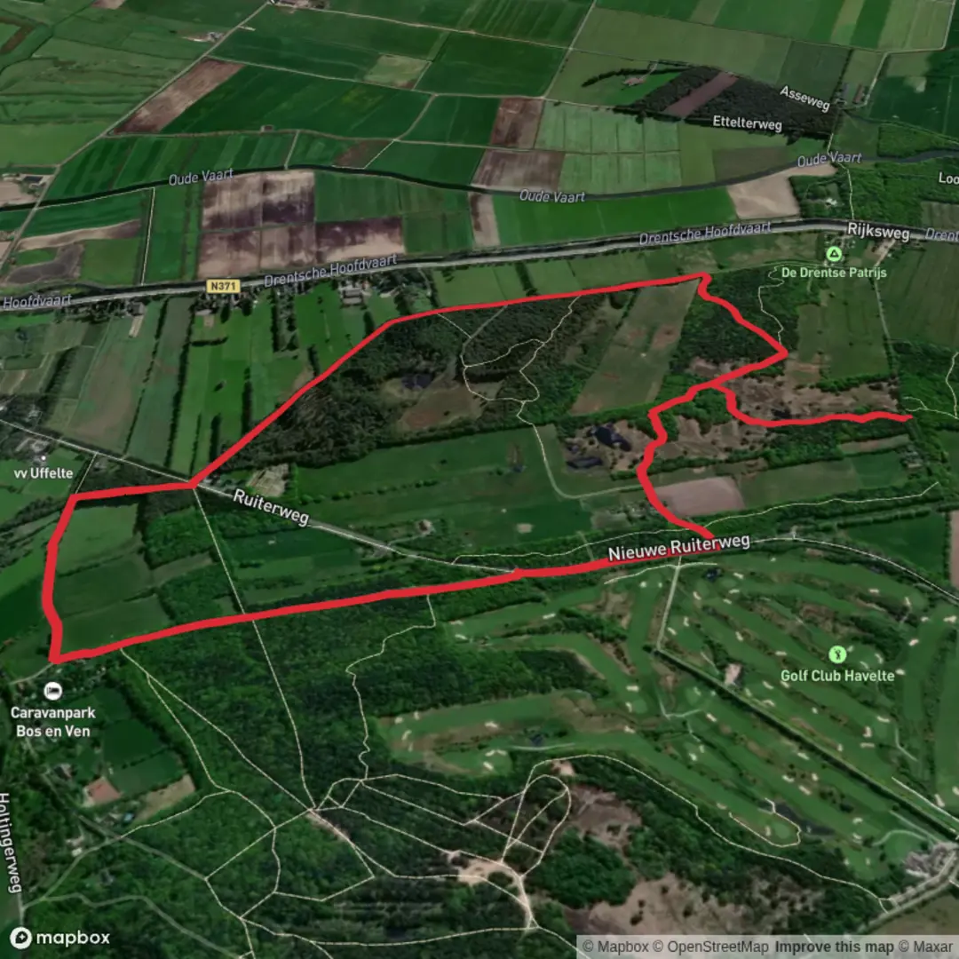
5.2 km
~1 hrs 2 min
0 m
Loop
“Drift through Drenthe’s wide-sky fields and whispering ditches on a calm, easy-going loop.”
A gentle, mostly level countryside loop of about 5 km (3.1 mi) with essentially 0 m (0 ft) of climbing, this walk is best planned as an unhurried circuit through the open fields and drainage-lined farmland typical of the Dutch “binnenveld” landscape. Expect wide skies, long sightlines, and easy footing—ideal for a short outing, a family walk, or a quick nature break.
Getting to the start (car + public transport)
Because the start point is listed only as “near” (no coordinates provided), the most reliable way to pinpoint the exact trailhead is to open the route in HiiKER and use its start-point pin to identify the nearest road access and parking.
That said, “Uffelter Binnenveld” strongly indicates the area near the village of Uffelte (Drenthe, Netherlands), close to the rural fields between Uffelte and surrounding hamlets. Once you share the route’s lon/lat (or a HiiKER link), I can translate it to the nearest known address or landmark (for example, a named road, a farm access lane, a chapel, or a signed parking pull-off).
- By car: In this region, starts are commonly reached via small country roads with limited shoulder space. Plan for informal roadside pull-ins or a small designated lot if the route begins near a nature access point. Arrive with a backup parking option in mind in case a verge is soft or posted as private.
- By public transport: The nearest practical approach is usually train to Meppel or Steenwijk, then a regional bus toward Uffelte/Havelte, followed by a short walk to the start. Rural bus frequency can be limited, especially evenings and Sundays—check the day-of schedule before committing.
What the route is like underfoot
With minimal elevation change, the main “difficulty” here is not steepness but surface and seasonal conditions:
- Farm tracks and field-edge paths: Often compacted gravel, dirt, or grass. After rain, expect muddy patches and occasional standing water in low spots.
- Drainage ditches and small bridges/culverts: The binnenveld landscape is shaped by water management. You’ll likely cross or parallel ditches, canals, and narrow drains—easy walking, but keep an eye on edges that can be undercut or slippery.
- Road crossings: Short stretches may use quiet lanes. Even when traffic is light, visibility can be reduced by hedges and bends—walk single file and stay alert.
Plan on 60–90 minutes at a relaxed pace for 5 km (3.1 mi), longer if you stop for birdwatching or photos.
Navigation (keep it simple, stay on the right lines)
This is the kind of loop where paths can look similar—straight tracks, repeating field boundaries, and multiple junctions that feel “almost the same.” Use HiiKER to: - confirm you’re taking the correct farm track at each junction, - avoid accidentally stepping onto private farmyards or signed no-access lanes, - stay on the intended line if a field-edge path is overgrown or temporarily diverted.
Landscape, nature, and wildlife to look for
The Uffelter Binnenveld area sits in a broader mosaic of Drenthe farmland, heaths, and woodland edges, so even a short loop can deliver a lot of subtle nature.
- Birdlife: Expect common open-country species—geese, ducks, coots along wetter lines; lapwings and other meadow birds in open fields (season-dependent); and buzzards/kestrels hunting over the margins. Early morning and late afternoon are often best for activity.
- Mammals: You may spot hares in open fields and roe deer near cover, especially where the route skirts hedgerows or small wooded strips.
- Plants and seasonal color: In spring and summer, field margins can carry wildflowers and grasses; in wetter spots, look for reeds and sedges. Late summer can bring tall growth that narrows paths—long socks help against ticks and nettles.
Landmarks and points of interest you may pass
On a short binnenveld loop, “landmarks” are often understated but meaningful: - Historic field patterns and waterworks: The straight ditches, managed drains, and parcel boundaries reflect centuries of land use and water control—part of what makes Drenthe’s rural landscape so distinctive. - Farmsteads and rural architecture: You may pass traditional farm buildings and long-established holdings. Treat these as working spaces: keep noise down, don’t block gates, and give machinery plenty of room. - Woodland/heath edges (if included on your exact line): If the loop brushes the transition zones toward nearby nature areas, you’ll notice a shift from open polder-like fields to more textured edges—often where wildlife sightings improve.
Practical prep for an easy 5 km (3.1 mi) loop
- Footwear: Light hiking shoes are usually enough; choose something with grip if it’s been wet.
- Clothing: Wind can be the main factor on open farmland—bring a light shell even on mild days.
- Ticks & insects: In warmer months, use repellent and do a tick check after walking through grass margins.
- Dogs: If allowed on your specific route line, keep dogs close around livestock and during ground-nesting bird season.
- Respect for access: The biggest “gotcha” in these landscapes is accidentally taking a track that looks public but is not. Follow signage and confirm with HiiKER at ambiguous junctions.
If you paste the

Surfaces
Unknown
Asphalt
Sand
Gravel
Comments and Reviews
User comments, reviews and discussions about the Uffelter Binnenveld Loop, Netherlands.
average rating out of 5
0 rating(s)