Halfweg Zwanenburg to Amsterdam Sloterdijk via NS - Wandeling De Bretten
Download
3D Flyover
Add to list
More
9.5 km
~1 hrs 53 min
0 m
Point-to-Point
“Wander through a ribbon of wildflowers, wetlands, and urban edges where city and nature entwine.”
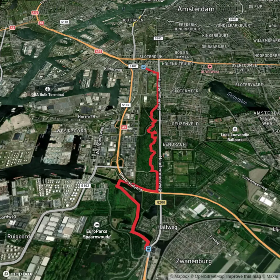
Starting near Halfweg-Zwanenburg station, this 9 km (about 5.6 miles) walk follows the NS-wandeling De Bretten, a green corridor threading between the urban edges of Halfweg and Amsterdam Sloterdijk. With virtually no elevation gain, this route is ideal for those seeking a leisurely, accessible hike through a unique blend of reclaimed Dutch polder landscape and wild urban nature.
Getting There
The trailhead is easily reached by public transport. Take a train to Halfweg-Zwanenburg station, located just west of Amsterdam and adjacent to the SugarCity complex, a former sugar factory now repurposed for events and offices. For those arriving by car, parking is available near the station, though spaces can be limited during weekdays.
Trail Experience and Navigation
Leaving the station, the path quickly immerses you in the De Bretten, a long, narrow greenbelt that serves as a vital ecological corridor. The route is well-marked and maintained, but for added confidence, use HiiKER for real-time navigation and waypoints.
Nature and Wildlife
De Bretten is a haven for urban wildlife. The area is characterized by wetlands, reed beds, and wildflower meadows, supporting a surprising diversity of birds—look for herons, kingfishers, and sometimes even kestrels hovering above the fields. The landscape is interspersed with willow groves and small ponds, remnants of the region’s history as reclaimed land from the IJ Bay. In spring and summer, the meadows burst with wildflowers and butterflies, while autumn brings a golden hue to the reeds.
Landmarks and Points of Interest
About 2 km (1.2 miles) in, you’ll pass under the A5 motorway, a striking juxtaposition of infrastructure and nature. The trail then weaves through secluded paths, occasionally crossing small bridges over drainage ditches—reminders of the Netherlands’ ongoing relationship with water management. At roughly the halfway point, you’ll encounter the Ruigoord artists’ village to the north, a former church and village now transformed into a creative enclave, though the trail itself skirts its southern edge.
As you approach Amsterdam Sloterdijk, the landscape shifts subtly, with more urban elements appearing. The final stretch leads you through the Westerpark area, a popular green space for locals, before ending at Sloterdijk station, a major transport hub with frequent trains, trams, and buses connecting to central Amsterdam and beyond.
Historical Significance
The De Bretten corridor traces the edge of the old Haarlemmermeer polder, land reclaimed from the former IJ Bay in the 19th century. The area’s network of ditches and canals is a living testament to Dutch ingenuity in water management. The route also passes near the site of the historic SugarCity factory, a nod to the region’s industrial past.
Practical Tips
The entire route is flat, making it suitable for all fitness levels and accessible year-round. Surfaces are a mix of paved and unpaved paths; after heavy rain, some sections can be muddy, so waterproof footwear is recommended. There are few facilities along the way, so bring water and snacks. Both Halfweg-Zwanenburg and Sloterdijk stations have shops and restrooms.
For navigation, download the route on HiiKER to ensure you stay on track, especially where the path branches near the motorway crossings. The walk is dog-friendly, but keep pets on a leash in nature reserves. Cyclists also use parts of the route, so stay alert on shared paths.

Surfaces
Unknown
Grass
Asphalt
Unpaved
Wood
Paved
Comments and Reviews
User comments, reviews and discussions about the Halfweg Zwanenburg to Amsterdam Sloterdijk via NS - Wandeling De Bretten, Netherlands.
average rating out of 5
0 rating(s)