Download
3D Flyover
Add to list
More
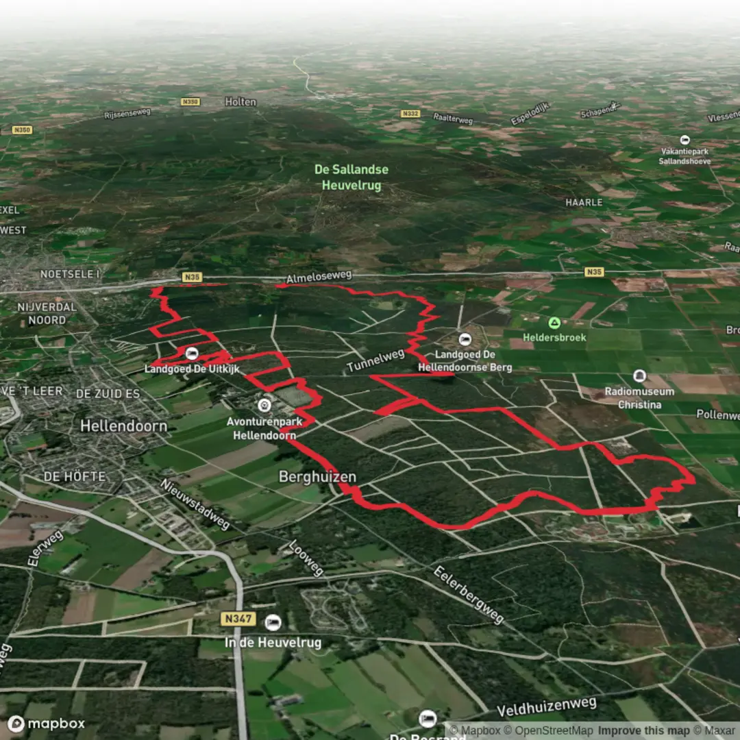
18.2 km
~3 hrs 44 min
63 m
Loop
“Wander through lush forests, blooming heath, and riverside paths, where Dutch history and nature entwine.”
The Hellendoornsche Loop is an approximately 18-kilometer (11-mile) circular trail with an elevation gain of around 100 meters (328 feet), offering an easy hiking experience through the diverse landscapes of the Overijssel province in the Netherlands.
Getting to the Trailhead
The trail begins in the village of Hellendoorn, located in the eastern Netherlands. For those traveling by car, Hellendoorn is accessible via the A1 motorway, taking the exit toward Rijssen/Hellendoorn, followed by the N347 road leading directly into the village. Parking is available near the Dorpsstraat/Raadhuisstraat intersection, which serves as a convenient starting point for the hike. (gps-route.org)
If using public transport, the nearest train station is in Nijverdal, approximately 3 kilometers (1.9 miles) south of Hellendoorn. From Nijverdal, local buses or taxis can transport you to the village center.
Trail Overview
Starting from the heart of Hellendoorn, the trail leads you into the serene forests of the Hellendoornse Berg. The initial segment is characterized by well-maintained paths meandering through dense woodlands, providing a tranquil atmosphere. Approximately 5 kilometers (3.1 miles) into the hike, you'll reach the banks of the Regge River.
Along the Regge River
Following the river's course for about 6 kilometers (3.7 miles), the trail offers picturesque views of the waterway, flanked by green fields and traditional Dutch farms. This section is relatively flat, making for a leisurely walk. Notable features along this stretch include a lock and fish ladder, showcasing the region's water management infrastructure. (gps-route.org)
Landgoed Schuilenburg
Departing from the river, the trail leads to Landgoed Schuilenburg, a historic estate. While the original castle no longer stands, remnants such as the moats and a reconstructed bridge are visible, offering a glimpse into the area's past. The surrounding woodlands, once part of the estate, provide a shaded and peaceful environment for hikers. (alltrails.com)
Return Through Rural Landscapes
The path then meanders through rural areas, passing by the Hellendoorn Sanatorium, a notable landmark. Continuing through forests and heathlands, the trail eventually leads to the Noorder Es, a traditional Dutch agricultural area. The final leg of the hike crosses this region, bringing you back to the village of Hellendoorn. (gps-route.org)
Flora and Fauna
Throughout the hike, especially in the sections along the Regge River and through the forests, hikers may encounter a variety of bird species, including herons and kingfishers. The heathlands are particularly vibrant during late summer when the heather blooms, painting the landscape in shades of purple.
Historical Significance
The region around Hellendoorn has a rich history, with settlements dating back to the Middle Ages. The village itself was first mentioned in 1078, and its church dates back to 1150. The area has evolved over centuries, balancing agricultural development with the preservation of its natural landscapes. (research.utwente.nl)
Navigation and Preparation
For detailed maps and navigation assistance, consider using HiiKER, which provides comprehensive information on this and other trails. The trail is well-marked, but carrying a navigation tool can enhance your hiking experience. Given the relatively flat terrain and well-maintained paths, standard hiking gear is sufficient. However, it's advisable to check local weather conditions before setting out and to carry sufficient water and snacks for the journey.
This hike offers a blend of natural beauty, historical landmarks, and cultural insights, making it a rewarding experience for those seeking to explore the Dutch countryside.
Surfaces
Unknown
Sand
Ground
Dirt
Asphalt
Grass
Cobblestone
Comments and Reviews
User comments, reviews and discussions about the Hellendoornsche Loop 2, Netherlands.
average rating out of 5
0 rating(s)