Download
3D Flyover
Add to list
More
5.8 km
~1 hrs 9 min
0 m
Loop
“Wander through blooming heaths, whispering woods, and echoes of history on this enchanting Dutch loop.”
The Berg Weg Haarle, Bergbosch, and Sprengenberg Loop is a scenic 6-kilometer (approximately 3.7 miles) trail located near Haarle in the province of Overijssel, Netherlands. This easy, circular route offers hikers a delightful journey through diverse landscapes, including forests, heathlands, and historical landmarks, with minimal elevation gain, making it accessible for all skill levels.
Starting Point and Accessibility
The trail begins at Erve De Pas, situated at Molenweg 2, 7448 RE Haarle. This location serves as both the trailhead and a visitor center, providing amenities such as parking, restrooms, and a café. For those traveling by public transport, the nearest train station is in Nijverdal. From there, you can rent a bicycle and ride approximately 8 kilometers (about 5 miles) to the starting point via Haarle. Alternatively, the route is accessible by car, with parking available at Erve De Pas. (humanitasonderdak.nl)
Trail Overview
Embarking from Erve De Pas, the trail is well-marked with green arrows, guiding hikers through the picturesque Sprengenberg area. The path meanders through a mix of dense forests and open heathlands, offering a variety of natural scenery. The terrain is predominantly flat, ensuring a comfortable hike suitable for families and casual walkers.
Key Landmarks and Points of Interest
Haarler Enk: Approximately 700 meters (0.4 miles) into the hike, you'll encounter the Haarler Enk, a traditional agricultural landscape characterized by rolling fields and meadows. This area showcases the harmonious blend of nature and farming practices typical of the region.
De Schaapskooi: At around 1.2 kilometers (0.75 miles), the trail passes by De Schaapskooi, a historic sheepfold. This spot is ideal for a short break, with picnic tables available and opportunities to observe local wildlife. The surrounding heathlands are home to grazing sheep, which play a crucial role in maintaining the landscape.
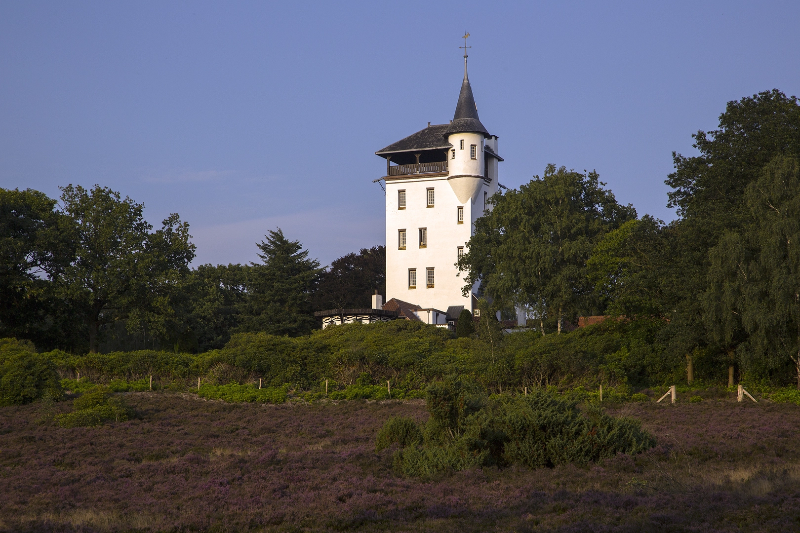
Palthetoren (Palthe Tower): A highlight of the route is the Palthetoren, a distinctive white tower perched atop the Sprengenberg hill. Built in the early 20th century, this tower was part of the estate owned by the Palthe family. While the tower itself is not open to the public, it remains a significant historical landmark and offers a glimpse into the area's aristocratic past. (wandeldingen.nl)
Flora and Fauna
The trail traverses diverse ecosystems, including mixed forests and expansive heathlands. Depending on the season, hikers can enjoy vibrant displays of rhododendrons, particularly in May and June. The heathlands are especially striking in late summer when the heather blooms, painting the landscape in shades of purple. Wildlife enthusiasts may spot roe deer, Scottish Highland cattle, and a variety of bird species, including the rare black grouse. (mooisteroutes.nl)
Historical Significance
The Sprengenberg area is rich in history, with the Palthetoren serving as a testament to the region's aristocratic heritage. The surrounding landscapes have been shaped by centuries of agricultural use, and the preservation efforts by organizations like Natuurmonumenten ensure that the cultural and natural history of the area is maintained for future generations.
Navigation and Safety
The trail is well-marked with green arrows, making navigation straightforward. For additional guidance, hikers can utilize the HiiKER app, which provides detailed maps and route information. It's advisable to wear sturdy footwear, as some sections may be uneven or muddy, especially after rain. Always check the weather forecast before setting out and carry sufficient water and snacks.
Getting There
By Car: Navigate to Erve De Pas at Molenweg 2, 7448 RE Haarle. Parking is available on-site.
By Public Transport: Take a train to Nijverdal station. From there, rent a bicycle and follow the route through Haarle to reach the trailhead, approximately 8 kilometers (5 miles) away. (humanitasonderdak.nl)
This loop offers a serene and enriching hiking experience, combining natural beauty with historical landmarks, making it a must-visit for those exploring the Overijssel region.

Surfaces
Unknown
Sand
Ground
Gravel
Asphalt
Comments and Reviews
User comments, reviews and discussions about the Berg Weg Haarle, Bergbosch and Sprengenberg Loop, Netherlands.
average rating out of 5
0 rating(s)