Download
3D Flyover
Add to list
More
21.5 km
~4 hrs 17 min
0 m
Loop
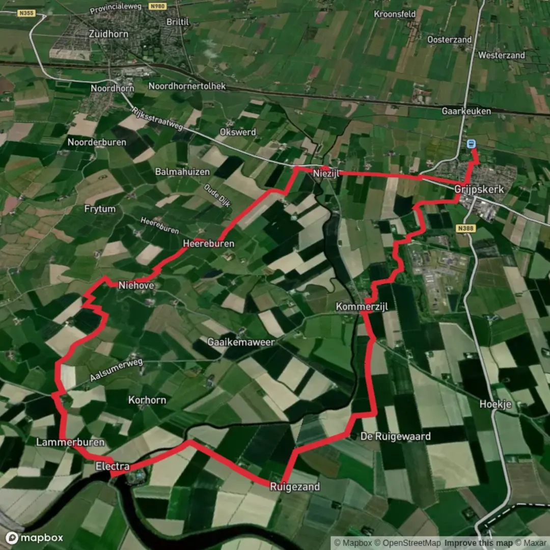
“A big-sky loop from Niehove’s spider‑web terp to polder waterworks, where wind writes the story.”
You’re walking in the wide-open coastal clay landscape of northwest Groningen (province), where “height” is mostly man‑made: dikes, terps (dwelling mounds), and raised farm tracks. This loop is about 21 km / 13.0 mi with roughly 0 m / 0 ft of climbing, but don’t underestimate it—wind exposure and long, straight polder roads can make it feel bigger than the numbers suggest.
The route links two very different landmarks of Dutch water history: - Ruigezandsterpolder / (Nieuwe) Ruigezandsterpolder: reclaimed farmland created by dikes and drainage works, tied to major 19th‑century coastal engineering around 1877 that reshaped the Lauwers/Reitdiep water management. - Niehove: a remarkably preserved terp village with a circular “spider‑web” street plan and a 13th‑century church at its center, protected for its historic layout and long settlement history.
Getting to the start (car + public transport)
Because “near” wasn’t specified, the most practical start for this loop is at Niehove village, where you’ll also find the most obvious landmark and a natural mid‑route break.
- Start landmark (recommended): near Niehove’s church (Reformed Church / Dorpskerk) in the center of the terp village (postcode area 9884, municipality Westerkwartier).
- By car: Navigate to Niehove village center and park considerately on the village edges (space is limited on the terp). Arriving early helps, especially on weekends when day‑trippers come to see the village.
- By public transport: The area is rural; typically you’ll combine train to Groningen (or Zuidhorn/Grijpskerk depending on your approach) with a regional bus toward the Oldehove/Niehove area, then a short walk. Check the latest bus stop options and walking approach in HiiKER so you can pin the most convenient stop to your chosen start point.
What the terrain is like (and why it’s “flat” but not always easy)
Expect a mix of: - Paved farm roads and quiet lanes between fields - Dike-top paths (often paved or compacted) - Occasional grassy verges that can be wet or soft after rain
Even with near‑zero elevation gain, you’ll feel constant micro‑changes: stepping up onto dikes, crossing bridges, and moving between exposed open fields and the sheltered bowl of Niehove’s terp.
Plan for 4.5–6 hours depending on wind, stops, and pace.
Route flow and key waypoints (approximate)
0.0 km / 0.0 mi – Niehove (terp village core) You begin in one of the Netherlands’ classic mound villages. Niehove’s layout is the feature: two ring roads encircle the mound, with narrow paths running like spokes up to the church. The church’s position isn’t just picturesque—it’s a flood‑survival strategy, placing the most important buildings on the highest ground.
2–6 km / 1.2–3.7 mi – Leaving the terp into open Humsterland As you step off the mound, the landscape opens into big skies and long sightlines. This is old coastal clay country shaped by centuries of embankment and drainage. You’ll pass: - Broad pastures and arable fields - Straight drainage ditches (watch footing near edges, especially in wind) - Farmsteads on slightly raised ground
6–12 km / 3.7–7.5 mi – Ruigezandsterpolder section (polder geometry and waterworks) Here the “design” of the land becomes obvious: rectilinear parcels, canals/ditches, and roads aligned for efficient drainage and farming. This area connects to the long history of poldering and dike building along the Lauwers and toward the former Lauwerszee. The 19th‑century works around 1877 (dike and sluice changes in the wider area) were part of a push to improve safety and control water levels—key to protecting agriculture and settlements in a region where storm surges and river outflows once interacted far more directly.
Practical notes: - Wind is the main hazard: there’s little shelter. In strong headwinds, your pace can drop sharply. - Road crossings are usually quiet, but farm traffic can be fast and silent on smooth pavement—stay alert on bends and at bridge approaches.
**12–17

Surfaces
Asphalt
Concrete
Unknown
Grass
Wood
Paved
Comments and Reviews
User comments, reviews and discussions about the Ruigezandsterpolder and Niehove Loop, Netherlands.
average rating out of 5
0 rating(s)