Download
3D Flyover
Add to list
More
15.0 km
~2 hrs 59 min
0 m
Point-to-Point
“Follow straight canals from village church to quiet, water-laced bogs—flat, wild, and reflective.”
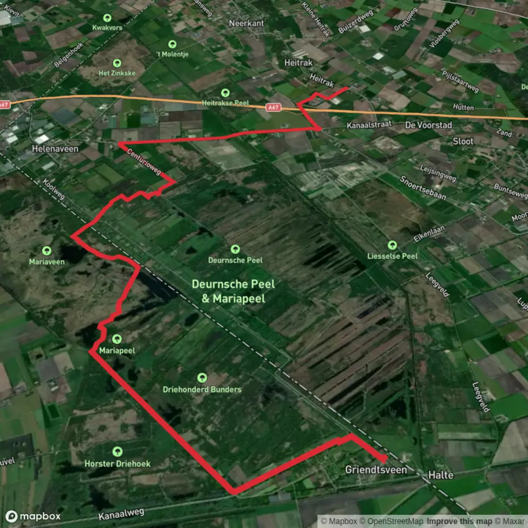
You’ll be walking through one of the Netherlands’ classic “Peel” peat landscapes—flat as a tabletop (expect roughly 0 m / 0 ft of climbing over ~15 km / ~9.3 mi) but full of water, open bog, and long straight canals that can make the terrain feel bigger and wilder than the map suggests. The route links the church area (“Kerk”) in/near the peat-colony villages around Griendtsveen / Helenaveen and finishes out by Rechte Heitraksedijk (a rural dike road in the Neerkant area, municipality of Deurne, North Brabant). (wandelnet.nl)
For a practical “nearest landmark” start point, most hikers treat Griendtsveen village center (near the church and the Helenavaart canal) as the obvious Kerk-area anchor. For the finish, Rechte Heitraksedijk, 5758 (Neerkant) is the key destination reference—plan your pickup/return transport around that road rather than expecting services at the endpoint. (wandelnet.nl)
Getting to the start (car + public transport)
By car: Aim for Griendtsveen and park near the village/canal area (often used as a walking hub). If you want a more formal trailhead-style landmark nearby, “Natuurpoort De Peel” is commonly used as a start/stop point for walks in this area and sits close to Griendtsveen’s walking network. (komoot.com)
By public transport: This part of the Peel is rural; bus service exists but can be infrequent. A reliable strategy is to route yourself to Deurne (larger town with rail connections) and continue by bus/taxi to Griendtsveen. Because the finish is on Rechte Heitraksedijk (spread-out countryside), it’s smart to pre-plan a pickup or use a two-car shuttle. (postcode.site)
What the walk feels like underfoot
Although the elevation is negligible, the surface changes constantly: village lanes and dike-top tracks, then peatland paths that can be soft, narrow, and seasonally wet. In and around Mariapeel you’ll often be near ditches, peat pools, and boggy margins, so waterproof footwear is a big comfort upgrade even on an “easy” profile day.
Navigation is generally straightforward because many lines in the landscape are dead-straight canals and dikes, but that same straightness can be disorienting in fog or low light—use HiiKER to confirm which parallel track you’re on when multiple straight options appear.
Landmarks and landscape highlights (with rough distance cues)
0–3 km (0–1.9 mi): Kerk area → Helenavaart & peat-colony edges
From the church/village core you quickly meet the geometry that defines the Peel: canals, bridges, and long sightlines. The Helenavaart is a signature feature here—named after Helena Panis, connected to the early peat-extraction era—and it acts like a guiding handrail for parts of the stage. (wandelnet.nl)
3–8 km (1.9–5.0 mi): Toward Mariapeel—open bog, heath, and water
As you push away from the village, the scenery opens into raised-bog remnants: wet hollows, reedbeds, rough grass, and patches of heath and young birch. Mariapeel and the neighboring Peel reserves are among the last fragments of what used to be a vast peat bog across this region; the “wild” look is largely the result of centuries of peat cutting, which left behind pools, trenches, and extraction scars that later re-naturalized. (fietsroutesinbeeld.nl)
Keep an eye out for boardwalk-like sections or narrow causeways where the route threads between wetter pockets. After rain, the edges of these paths can be slick—give cyclists space on shared tracks and step off carefully where the shoulder drops into a ditch.
8–12 km (5.0–7.5 mi): Deepest Peel character—quiet, bird-rich wetlands
This is the stretch where the Peel’s reputation for birds makes sense. The mix of open water, reedbeds, and quiet flats supports large numbers of waterfowl and raptors; the broader Peel region is widely noted as very bird-rich, with cranes sometimes seen in the wider Peel area in autumn. (fietsroutesinbeeld.nl)
Because the habitat

Surfaces
Asphalt
Unknown
Sand
Dirt
Unpaved
Gravel
Wood
Comments and Reviews
User comments, reviews and discussions about the Kerk to Rechte Heitraksedijk via Griendtsveen and Mariapeel, Netherlands.
average rating out of 5
0 rating(s)