Download
3D Flyover
Add to list
More
39.7 km
~2 days
6 m
Multi-Day
“Wander through whispering woods, blooming heaths, and ancient villages on this gentle, nature-filled loop.”
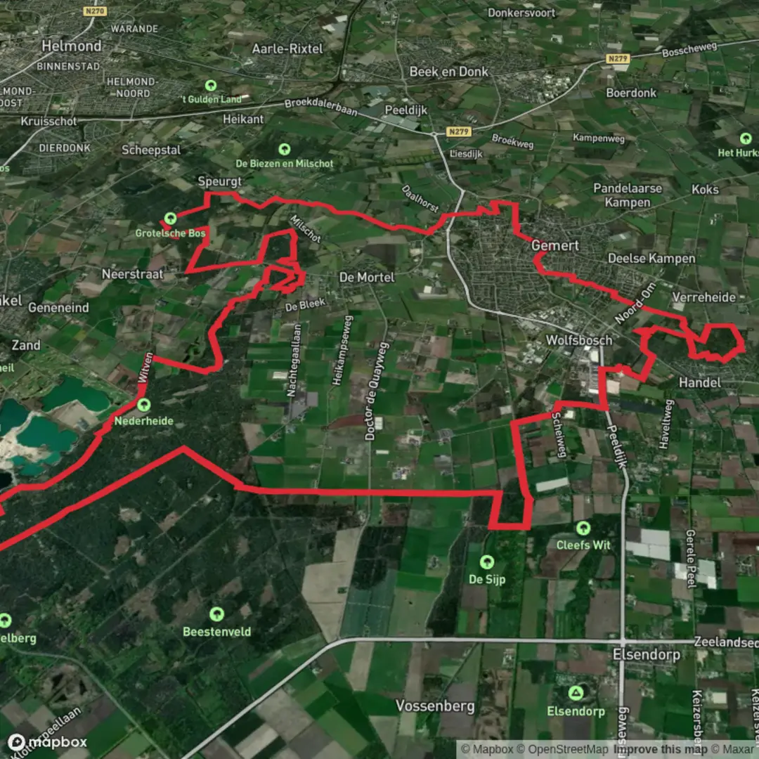
Starting from the outskirts of Bakel, a small village in North Brabant, the Nederheide and Grotelsche Bos Loop covers approximately 40 km (about 25 miles) with virtually no elevation gain, making it an accessible and gentle long-distance walk for most fitness levels. The trailhead is conveniently located near the Nederheide recreational area, which is well-signposted and easy to reach by car, with parking available at Strandbad Nederheide. For those using public transport, buses from Helmond or Deurne stop in Bakel, from where it’s a short walk to the starting point.
Woodlands, Heath, and Waterways
The route meanders through the tranquil Grotelsche Bos, a mixed woodland known for its tall pines, ancient oaks, and carpets of moss. Early in the hike, you’ll pass the serene Grotelsche Heide, a heathland that bursts into purple bloom in late summer. The area is interspersed with small ponds and streams, remnants of historic peat extraction and natural watercourses. Birdwatchers should keep an eye out for woodpeckers, buzzards, and the occasional kingfisher along the banks of the Snelle Loop stream.
Cultural and Historical Highlights
About 10 km (6 miles) in, the trail skirts the edge of the medieval village of Bakel, one of the oldest settlements in the region, with a church dating back to the 12th century. The route also passes close to the Grotel watermill, a picturesque spot with roots in the 14th century, once vital for grinding grain for local farmers. Interpretive signs along the way provide insight into the area’s agricultural history and the transformation of heathland into productive farmland.
Navigational Tips and Trail Conditions
The loop is well-marked, but the dense forest sections and occasional junctions with local cycling paths can be confusing. For reliable navigation, download the route to your phone using HiiKER, which provides up-to-date trail maps and GPS guidance. The terrain is mostly flat and consists of sandy forest paths, gravel tracks, and some paved rural roads. After heavy rain, some sections near the heath and streams can become muddy, so waterproof footwear is recommended.
Wildlife and Seasonal Changes
Deer, foxes, and rabbits are common throughout the woodlands, while the open heath attracts butterflies and dragonflies in warmer months. In spring, the forest floor is dotted with wildflowers, and in autumn, mushrooms and toadstools add color to the landscape. The loop’s length and lack of significant elevation make it ideal for a full-day hike, with several picnic spots and benches along the way for rest and refreshment.
Access and Amenities
Restrooms and a café can be found at the Nederheide recreational area at the start and finish. Water refill points are limited, so bring sufficient supplies, especially in summer. The nearest major town, Helmond, offers additional accommodation and dining options for those planning an overnight stay before or after the hike.

Surfaces
Unknown
Asphalt
Unpaved
Sand
Dirt
Gravel
Paved
Comments and Reviews
User comments, reviews and discussions about the Nederheide and Grotelsche Bos Loop, Netherlands.
average rating out of 5
0 rating(s)