Download
3D Flyover
Add to list
More
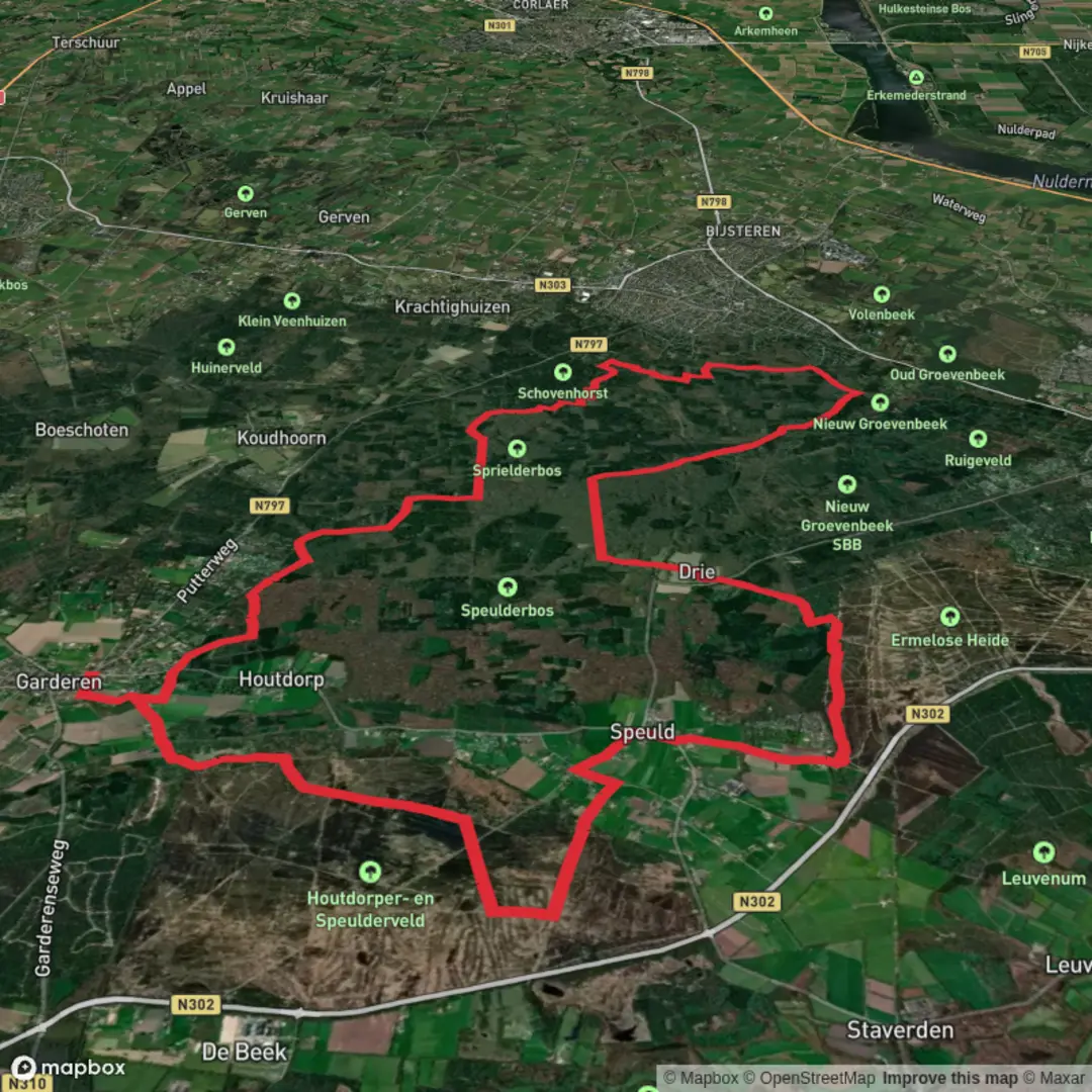
27.1 km
~5 hrs 27 min
31 m
Loop
“A near-flat Veluwe loop through dancing pines, sandy lanes, and heathy horizons that can feel longer.”
You’re looking at a long, almost pancake-flat Veluwe circuit of about 27 km / 16.8 mi with essentially 0 m / 0 ft of “real” climbing—but don’t be fooled: the Veluwe’s gentle rises, soft sand, and long forest lanes can make this feel longer than the numbers suggest. The loop links three distinct landscapes: the older, characterful forests of the Speulder- and Sprielderbos, the local woodland character of the Putterbosch/Putterbos area, and the more open, heath-and-field feel around Houtdorperveld.
A very practical start landmark (and an easy one to navigate to) is Boshuis Drie, Sprielderweg 205, 3852 MK Ermelo (hamlet of Drie)—right on the edge of the Speulder- and Sprielderbos and close to major forest tracks and parking. (boshuisdrie.nl)
Getting to the start (car + public transport)
By car
- Aim for Sprielderweg (near Drie) and park at one of the larger forest parking areas along this road; Staatsbosbeheer notes a large parking area just outside buurtschap Drie on/near the Sprielderweg where multiple walking and riding routes begin. (staatsbosbeheer.nl)
- If you want a “pin” that’s easy for navigation and meeting up, use Boshuis Drie (Sprielderweg 205, 3852 MK Ermelo) and park nearby where permitted. (boshuisdrie.nl)
By public transport - The nearest rail hub is typically Ermelo station, then you’ll need a bus/taxi or a longer approach walk/ride to reach Drie/Sprielderweg. For planning the exact stop-to-trailhead connection on the day you go, build the route in HiiKER and cross-check with local transit planners (service patterns can vary by day/season).
What the route feels like underfoot
Expect a mix of: - Wide forest roads (fast, easy navigation, but can feel repetitive if you don’t like long straight lines) - Sandy stretches (common on the Veluwe; they can sap energy and slow pace) - Heath/field edges near Houtdorperveld (more open sky, more wind exposure)
Because the elevation change is minimal, the main “difficulty” variables are distance, surface (sand), and navigation discipline at junction-dense forest grids. If you’re using HiiKER, keep an eye on frequent intersections where parallel tracks run close together—this is where people most often drift onto the wrong lane.
Kilometer-by-kilometer expectations (approximate)
0–6 km / 0–3.7 mi: Into the “dancing trees” forest
You’ll quickly be in the Speulder- and Sprielderbos—often described as one of the Netherlands’ oldest forest complexes and famous for its crooked, “dancing” trees, especially around Drie. (en.veluwespecialist.nl)
The atmosphere here is classic Veluwe: tall trunks, filtered light, and a quiet, enclosed feel. Early on, it’s worth settling into a sustainable pace—27 km is long enough that a slightly-too-fast start will show up later.
6–14 km / 3.7–8.7 mi: Deep forest lanes + cultural traces This middle portion is typically the most “forest-immersed,” with long, runnable lanes broken by occasional clearings and junctions. Keep your attention up for: - Wildlife movement at the edges of clearings, especially around dawn/dusk. - Quiet zones / restricted areas: Staatsbosbeheer notes that some “rest areas” are not accessible year-round—follow signage if a track is closed. (staatsbosbeheer.nl)
If your loop passes near the WWII-era Onderduikershol (underground hiding place) near Drie, it’s a significant historical point: sources describe it as used during Feb 1943–Jul 1944 by fugitives (including British pilots) before being discovered in 1944. (fietsnetwerk.nl)
Even if you don’t detour to it, this part of the Veluwe carries a lot of wartime history—many forests here provided concealment and routes away from main roads.

Surfaces
Unknown
Sand
Ground
Asphalt
Gravel
Unpaved
Dirt
Paved
Concrete
Grass
Comments and Reviews
User comments, reviews and discussions about the Sprielderbosch and putterbosch and Houtdorperveld Loop, Netherlands.
average rating out of 5
0 rating(s)